Nesna is a municipality in Nordland county, Norway. It is part of the Helgeland traditional region. The administrative centre of the municipality is the village of Nesna. Other villages in Nesna include Handnesneset, Husby, Saura, and Vikholmen.

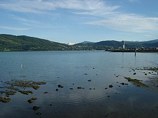
Mo i Rana is a city, and the administrative centre of the municipality of Rana, in Nordland county, Norway. It is located in the Helgeland region of Nordland, just south of the Arctic Circle. Some of the city's suburbs include Båsmoen and Ytteren in the north, Gruben in the south east, Selfors in the east, and Åga/Hauknes/Dalsgrenda in the south.
Rana is a municipality in Nordland county, Norway. It is part of the Helgeland traditional region. The administrative centre of the municipality is the town of Mo i Rana, which houses the National Library of Norway. Other population centers in Rana include Båsmoen, Dunderland, Eiteråga, Flostrand, Hauknes, Mæla, Myklebustad, Nevernes, Røssvoll, Selfors, Skonseng, Storforshei, Utskarpen, and Ytteren.

Helgeland is the most southerly district in Northern Norway. Generally speaking, Helgeland refers to the part of Nordland county that is located south of the Arctic Circle. It is bordered in the north by the Saltfjellet mountains and Svartisen glacier, which form a natural border with the Salten district. In the south, Helgeland borders Trøndelag county.
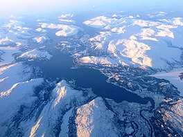
The Dunderland Valley is a valley in the municipality of Rana in Nordland county, Norway. It reaches from just below the eastern Saltfjellet plateau about 8 miles (13 km) south of the Arctic circle. The mountain Bolna is situated in the uppermost boundary of the valley which then proceeds to the southwest all the way down to the Ranfjorden. Some of the minor side valleys include Plurdalen, Røvassdalen, Bjøllådalen, Grønfjelldalen and Virvassdalen. The valley also includes several villages such as Krokstrand, Bjøllånes, Storvoll, Dunderland, Eiterå, Nevernes, Storforshei, Nevermoen and Røssvoll.

Andfiskvatnet is a lake in the municipality of Rana in Nordland county, Norway. The 2.7-square-kilometre (1.0 sq mi) lake lies about 3 kilometres (1.9 mi) southeast of the village of Hauknes and about 6 kilometres (3.7 mi) south of the town of Mo i Rana. The lake flows out into the river Andfiskåga which flows into the Ranfjorden.

Raudvatnet is a lake in the municipality of Rana in Nordland county, Norway. The European route E12 highway passes along the northern and eastern shores of the lake between the town of Mo i Rana and the border with Sweden. A Red cross hut (Rauvasshytta) is located east of the lake Raudvatnet. Water flows into the lake Raudvatnet primarily from the nearby lake Tverrvatnet to the south. From Raudvatnet, the water flows into the river Tverråga, a tributary to the main river Ranelva.

Sør-Rana is a former municipality in Nordland county, Norway. The 777-square-kilometre (300 sq mi) municipality existed from 1929 until 1964. Sør-Rana encompassed an area on both sides of the middle section of the Ranfjorden around where the Sørfjorden and Elsfjorden branch off the main fjord.
Nord-Rana is a former municipality in Nordland county, Norway. The 3,980-square-kilometre (1,540 sq mi) municipality existed from 1839 until its dissolution in 1964. From 1839 until 1844, it was named Nord-Ranen, from 1844 until 1923, it was called Mo, and then from 1923 until 1964 it was named Nord-Rana. The former municipality was located at the innermost part of the Ranfjorden. It encompassed the eastern 90% of what is now Rana Municipality. The administrative centre was the village of Ytteren, just north of the town of Mo i Rana.
Flostrand is a village in the municipality of Rana in Nordland county, Norway. It is located along Norwegian County Road 17 on the northern bank of the Sjona fjord.
Myklebustad or Myklebostad is a village in the municipality of Rana in Nordland county, Norway. It is located along Norwegian County Road 17 on the southern bank of the Sjona fjord, just west of the villages of Mæla and Utskarpen. Sjona Church is located in the western part of Myklebustad, serving the western part of Rana municipality.
Mæla is a village in the municipality of Rana in Nordland county, Norway. It is located along Norwegian County Road 17 at the eastern end of the Sjona fjord, about 2 kilometres (1.2 mi) north of the villages of Utskarpen and Myklebustad.

Ranelva is a 130-kilometre (81 mi) long river in the municipality of Rana in Nordland county, Norway. It is one of the longest rivers in Nordland county. The catchment area of the river is 3,790 square kilometres (1,460 sq mi). Before the power stations of Reinforsen (1925) and Langvatnet (1964) were built, the catchment area was 3,843 square kilometres (1,484 sq mi).

Selfors is a village in the municipality of Rana in Nordland county, Norway. Selfors sits on the northern shore of the river Ranelva and it is a northeastern suburb of the town of Mo i Rana. The European route E06 highway passes through the village. Selfors has been inhabited since the Iron Age.

Virvasselva or Virvassåga (Norwegian) or Viresjåhkå (Lule Sami) is a river in the municipality of Rana in Nordland county, Norway. The river flows out of the eastern part of the lake Virvatnet. The stream Boneselva meets Virvasselva about 1 kilometre (0.62 mi) east of the lake Virvatnet. This is a large, continuous, very rich and untouched wetland area with tarns, rivers, marshes, and very tight vegetation. Virvasselva has a good population of Arctic char.
Utskarpen is a village in the municipality of Rana in Nordland county, Norway, about 37 kilometres (23 mi) west of the town of Mo i Rana. The village is located at the end of the Utskarpen fjord, an arm of the main Ranfjorden. On the western side of Utskarpen is the intersection with Norwegian County Road 17 and Norwegian County Road 12. The neighboring villages are Mæla to the north and Myklebustad to the west.

Tverrvatnet or Tvervatnet [tvær'vatne] is a lake in the municipality of Rana in Nordland county, Norway. The European route E12 highway passes along the northern and eastern shores of the lake between the town of Mo i Rana and the border with Sweden. Tverrvatnet gets its name from the fact that it is located "across", in a north–south direction, while most lakes in Rana are located in an east–west direction.

Ytteren is a village in the municipality of Rana in Nordland county, Norway. Ytteren and the neighboring village of Båsmoen are northern suburbs of the town of Mo i Rana. They are both located on the northern edge of the mouth of the Ranelva river at the Ranfjorden. Norwegian County Road 12 runs through the village. The large lake Langvatnet lies about 2 kilometres (1.2 mi) north of the village.
Bardal is a village in the municipality of Leirfjord in Nordland county, Norway. The village is located along the south coast of the Ranfjorden, about 10 kilometres (6.2 mi) west of the village of Hemnesberget. The village surrounds the Bardalselva river which flows into the fjord. The Bardal Church was built in 1887 on a hill near the mouth of the river. The Bardal area has historically been part of both Nesna Municipality and Hemnes Municipality, but it has been part of Leirfjord Municipality since 1964.

Hugla is an island in the municipality of Nesna in Nordland county, Norway. The 17.9-square-kilometre (6.9 sq mi) island lies south of the islands of Tomma and Handnesøya, west of the mainland of Nesna, east of the island of Løkta, and north of the Ranfjorden. The residents of the island live mostly on the eastern coast, across the fjord from the village of Nesna.