Hansapur is a small town in Arghakhanchi District in the Lumbini Zone of southern Nepal. At the time of the 1991 Nepal census, the town had a population of 7407 living in 1458 houses. At the time of the 2001 Nepal census, the population was 8103, of which 53% was literate.
Devisthan is a village development committee in Baglung District in the Dhaulagiri Zone of central Nepal. At the time of the 1991 Nepal census it had a population of 6,151 and had 1247 houses in the town.
Gokuleshwar is a Village Development Committee in Baitadi District in the Mahakali Zone of western Nepal. At the time of the 1991 Nepal census it had a population of 3,444 and had 601 houses in the town.
Mahadevsthan is a village development committee in Baitadi District in the Mahakali Zone of western Nepal. At the time of the 1991 Nepal census it had a population of 3,291 and had 599 houses in the town.
Kadel is a village in Bajhang District in the Seti Zone of north-western Nepal. At the time of the 1991 Nepal census it had a population of 3,816 and had 693 houses in the village.
Indrapur is a town in Banke District in Lumbini Province of south-western Nepal. At the time of the 1991 Nepal census it had a population of 5,403 and had 1056 houses in the town. It had been a part of Nepalgunj sub-metropolitan city while expansion of municipality in to sub metropolitan city. However, this part of Sub-metropolitan city was structured under Janaki Rural Municipality.

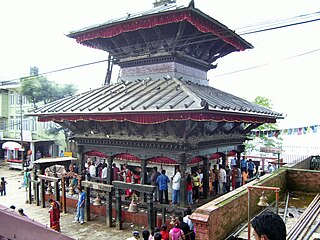
Manakamana is a village development committee in Gorkha District in the Gandaki Zone of northern-central Nepal. At the time of the 1991 Nepal census it had a population of 5,083 and had 889 houses in the town.
Dhodalekhani is a village development committee in Bhojpur District in the Kosi Zone of eastern Nepal. At the time of the 1991 Nepal census it had a population of 2412 persons living in 455 individual households.
Kudak Kaule is a village development committee in Bhojpur District in the Kosi Zone of eastern Nepal. At the time of the 1991 Nepal census it had a population of 2734 persons living in 507 individual households.
Chhata Pipra is a town in Gadhimai Municipality in Bara District in the Narayani Zone of south-eastern Nepal. The formerly Village Development Committee was merged to form new municipality on 18 May 2014. At the time of the 2011 Nepal census it had a population of 7,175 persons living in 1,065 individual households. There were 3,674 males and 3,501 females at the time of census.
Kakadi is a town and Village Development Committee in Bara District in the Narayani Zone of south-eastern Nepal. At the time of the 1991 Nepal census it had a population of 2,808 persons living in 482 individual households.
Kadamandau is a village development committee in Doti District in the Seti Zone of western Nepal. At the time of the 1991 Nepal census it had a population of 3084 living in 609 individual households.
Pokhari is a Village Development Committee in Doti District in the Seti Zone of western Nepal. At the time of the 1991 Nepal census it had a population of 2968 residing in 632 individual households.
Bala is a Village Development Committee in Sankhuwasabha District in the Kosi Zone of north-eastern Nepal. At the time of the 1991 Nepal census it had a population of 2863 people residing in 576 individual households.
Ghortikharka is a village development committee in Dhankuta District in the Kosi Zone of eastern Nepal. At the time of the 1991 Nepal census it had a population of 2736 people living in 494 individual households.
Rangapur is a village development committee in Rautahat District in the Narayani Zone of south-eastern Nepal. At the time of the 1991 Nepal census it had a population of 8141 people living in 1487 individual households.
Santpur is a town and market center in Chandrapur Municipality in Rautahat District in the Narayani Zone of south-eastern Nepal. The formerly village development committee was merged to form the municipality on 18 May 2014. At the time of the 1991 Nepal census it had a population of 5594.
Basantpur is a village development committee in Parsa District in the Narayani Zone of southern Nepal. At the time of the 2011 Nepal census it had a population of 7,933 people living in 1,157 individual households. There were 4,094 males and 3,839 females at the time of census.
Udayapur Dhurmi is a village development committee in Parsa District in the Narayani Zone of southern Nepal. At the time of the 2011 Nepal census it had a population of 7,163 people living in 1,085 individual households.

