The River Nagavali also known as Langulya is one of the main rivers of Southern Odisha and Northern Andhra Pradesh States in India, between Rushikulya and Godavari basins.

Ramagiri is a village in Anantapur district of the Indian state of Andhra Pradesh. It is the mandal headquarters of Ramagiri mandal in Dharmavaram revenue division.
Rawu is the name of a town in Baxoi County, Qamdo Prefecture, part of the Tibet Autonomous Region of China. It is at an altitude of 3,807 m (12,490 ft). The modern town of about 20 shops and hotels services the loggers and nearby military base.
Kairana Lok Sabha constituency is one of the 80 Lok Sabha (parliamentary) constituencies in Uttar Pradesh state in northern India.

Franciszkany is a village in the administrative district of Gmina Nowy Kawęczyn, within Skierniewice County, Łódź Voivodeship, in central Poland. It lies approximately 3 kilometres (2 mi) north-west of Nowy Kawęczyn, 8 km (5 mi) south-east of Skierniewice, and 54 km (34 mi) east of the regional capital Łódź.
Anonin is a village in the administrative district of Gmina Stanin, within Łuków County, Lublin Voivodeship, in eastern Poland. It lies approximately 4 kilometres (2 mi) north of Stanin, 12 km (7 mi) west of Łuków, and 77 km (48 mi) north of the regional capital Lublin.
Trzecianów is a village in the administrative district of Gmina Borek Wielkopolski, within Gostyń County, Greater Poland Voivodeship, in west-central Poland. It lies approximately 3 kilometres (2 mi) south-west of Borek Wielkopolski, 15 km (9 mi) east of Gostyń, and 60 km (37 mi) south of the regional capital Poznań.
Patharwadi is a village in Parner taluka in Ahmednagar district of state of Maharashtra, India.
Jaee is a village situated in Machra Mandal of Meerut District in Uttar Pradesh, India. It is located 9.705 km distance from Machhra, and lies south east of the district headquarters at Meerut approximately 14.91 kilometres.
Jhabiran is a village situated in the Nakur mandal of Saharanpur District in Uttar Pradesh, India. It is about 600 kilometres from the state capital Lucknow. There are two villages that go by the name Jhabiran.
Chandavaram is a village in Nadendla Mandal, Guntur District, Andhra Pradesh, India. Chandavaram is 8 km (5.0 mi) away from its Mandal headquarters in Nadendla.
Baghra is a town situated in the Baghara Mandal of Muzaffarnagar District in Uttar Pradesh, India. A big community of Hindus.. Many hindus temple are located here. It is located 11.83 kilometres from the district headquarters at Muzaffarnagar, and is 440 kilometres from the state capital Lucknow. Baghra is the headquarters of the Baghara Mandal, the lowest administrative unit in Uttar Pradesh. The town was the centre of a Muslim Baloch principality in the 18th Century. Baghra is popular because Dargah Aliya Babul Hawaiz is situated here and every year more than 2 Lakhs people reach here for worship. It has a population of about 20,122 people living in around 2931 households.
Jasoi is a village situated in the Baghara Mandal of Muzaffarnagar District in Uttar Pradesh, India. It is 8.140 kilometres from the Mandal headquarters at Baghra, and 19.10 kilometres from the district headquarters at Muzaffarnagar.
Ajrara is a village situated in the Kharkhoda Mandal of Meerut District in Uttar Pradesh, India. It is located 7.5 kilometres from its Mandal headquarters at Kharkhoda, and 20 kilometres from the district headquarters in Meerut. The population of Ajrara, according to the 2001 Census of India, was 11,513, and it is mainly a Muslim village, with Muslim Tyagis forming an important element.
Khiwai is a town and nagar panchayat situated in the Saroorurpur khurda Block of Meerut District in Uttar Pradesh, India. It is located at a distance of 7.916 kilometres from the Mandal headquarters at Sarurpur Khurd, and is 26.16 kilometres from the district headquarters at Meerut. The population, according to the 2001 Census of India was 14,944, and the village is largely Muslim.
The Bheema lift irrigation project or Rajiv Bheema Project is a lift irrigation canal project located in Mahbubnagar district in Telangana, India. Water is lifted at Panchdev Pahad from the back waters of Jurala Dam. Under the same project, another lift canal originates separately from the Ramanpahad balancing reservoir under Jurala left bank to irrigate the uplands.
Gopali is a village situated in the Deoband Mandal, of Saharanpur District, Uttar Pradesh, India. The village 11.08 kilometres from its Mandal headquarters at Deoband.
Manki is a village situated in the Deoband Mandal of Saharanpur District in the state of Uttar Pradesh. The village is 5 kilometres (3.1 mi) from its Mandal headquarters at Deoband. Manki is known for GADA Biradri or GAUR. It is also famous for ancient Shiv Mandir (Shivalay Manki is famous for its hospitality. Every year bhole come from different part of country stay there at Shiv Mandir and the go to Haridwar for taking holly bath. Every Monday in sawan month, a festival is organised at Shiv Mandir and people from across the country join this festival.
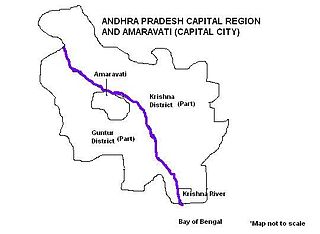
Andhra Pradesh Capital Region is the conurbation or metropolitan area surrounding Amaravati, the new capital city of Andhra Pradesh. The entire region is under the jurisdiction of Andhra Pradesh Capital Region Development Authority, and covers an area of 8,603 km2 (3,322 sq mi) under 58 mandals, of which 29 are in Krishna district and 29 in Guntur district. The capital region covers 18 mandals fully and 11 mandals partially in Guntur district. In Krishna district, it covers 15 mandals fully and 14 mandals partially under the jurisdiction of APCRDA. The capital city is an Urban Notified Area, and will cover 217.23 km2 (83.87 sq mi), within the Andhra Pradesh Capital Region.