Saharanpur division is an administrative geographical unit of Uttar Pradesh state of India. The city of Saharanpur is the administrative headquarters of the division.
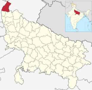
Saharanpur district is the northernmost of the districts of Uttar Pradesh state, India. Bordering the states of Haryana, Himachal Pradesh and Uttarakhand, and close to the foothills of Shivalik range, it lies in the northern part of the Doab region. It is primarily an agricultural area.
Muhammad Qasim Nanautavi was an Islamic Scholar and was one of the founders, along with Rashid Ahmad Gangohi, responsible for establishing the Deoband Movement.
Abū Ibrāhīm K͟halīl Aḥmad ibn Majīd ‘Alī Anbahṭawī Sahāranpūrī Muhājir Madanī was a Deobandi Hanafi Islamic scholar from India who authored Badhl al-Majhud, an 18-volume commentary on the hadith collection Sunan Abi Dawud. He was also a Sufi shaykh of the Chishti order, being a disciple and successor of Rashid Ahmad Gangohi.
The Pathans of Uttar Pradesh, have a large community of Pashtuns in the state of Uttar Pradesh in India, who form one of the largest Muslim communities in the state. They are also known as khans, which is a commonly used surname, although not all those who use the surname are Pathans, for example the Khanzada community of eastern Uttar Pradesh, who are Muslim Rajputs, are also commonly known as khan. Indeed, in Awadh, the boundary between the Khanzada and Pathans are blurred. In addition, the phrase Pathan Khanzada is used to describe Muslim Rajput groups, found mainly in Gorakhpur, who have been absorbed into the Pathan community. However, in Rohilkhand, and in parts of the Doab and Awadh, there are genuine communities of Pashtuns, such as the Rohilla.
Muhammad Yaqub Nanautawi (1833–1884) - alternately, Nanotvi - was an Indian Islamic scholar, and one of the earliest teachers of Islamic Madrassa in Deoband, famously called Darul Uloom Deoband in India.
Garhi Abdulla Khan is a village situated in Thana Bhawan Block of Shamli district. i.e. Tahsil OON Uttar Pradesh, India. The village was Established by the grand father of Baloch community, the late Mr. Abdullah Khan. The Abdullah Khan Shrine is still located at the central part of the village. It is one of the main villages among the alternates of Biloch community in Western Uttar Pradesh. It is located about 50 km kilometers from the mandal headquarters Saharanpur and 32 km from district headquarter Shamli. It's Located on Onn- Thanabhawan Road.This village is famous for Ramlila.All communities of this village are living with peacefully.In outer of this village, a temple is situated of Lord Shiva known as Shivalaya. It's an ancient village there are three major religious ancient monuments mosque khan -Kaha and ancient temple Shivalaya dedicated to lord Shiva and Jain Temple of British Period dedicated to Lord Mahaveer Swami.There are first Nav Graha Temple of District Shamli known as Shani Dev Dham. It's located on Titron Road. There are two km belt of Mango Orchard towards Titron Road. Major Schools And Colleges: Chaudhary Dhiraj Singh Intermediate College affiliated to UP Board Allahabad. SDS Public School affiliated to CBSE New Delhi. It's now a small town but it's under Gram Panchayat.
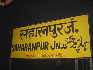
Saharanpur railway station is a railway station on the Northern Railway network in the state of Uttar Pradesh, India.
The Old Delhi – Meerut – Saharanpur line is a railway line connecting Old Delhi and Saharanpur. This page includes the Meerut - Khurja link. The line is under the administrative jurisdiction of Northern Railway.
Saharanpur Assembly constituency is one of the 403 constituencies of the Uttar Pradesh Legislative Assembly, India. It is a part of the Saharanpur district and one of the five assembly constituencies in the Saharanpur. Saharanpur Assembly constituency came into existence in 1955 as a result of the "Final Order DC (1953-1955)". The extant and serial number of this constituency was last defined in "Delimitation of Parliamentary and Assembly Constituencies Order, 2008".
Saharanpur Nagar Assembly constituency is one of the 403 constituencies of the Uttar Pradesh Legislative Assembly, India. It is a part of the Saharanpur district and one of the five assembly constituencies in the Saharanpur. First assembly election in this assembly constituency was conducted in 2012 after the constituency came into existence in the year 2008 as a result of the "Delimitation of Parliamentary and Assembly Constituencies Order, 2008". VVPAT facility with EVMs will be here in 2017 U.P assembly polls.
Rampur Maniharan Assembly constituency is one of the 403 constituencies of the Uttar Pradesh Legislative Assembly, India. It is a part of the Saharanpur district and one of the five assembly constituencies in the Saharanpur. First assembly election in this assembly constituency was conducted in 2012 after the constituency came into existence in the year 2008 as a result of the "Delimitation of Parliamentary and Assembly Constituencies Order, 2008".
Gangoh Assembly constituency is one of the 403 constituencies of the Uttar Pradesh Legislative Assembly, India. It is a part of the Saharanpur district and one of the five assembly constituencies in the Kairana. First assembly election in this assembly constituency was conducted in 2012 after the constituency came into existence in the year 2008 as a result of the "Delimitation of Parliamentary and Assembly Constituencies Order, 2008".
Tilfara Ainabad is a village situated in the Nanauta Mandal of Saharanpur District in Uttar Pradesh, India. Tilfara Ainabad is located 10.80 kilometres from the Mandal headquarters in Nanauta, 133 km distance from the national capital Delhi and is 458 km distance from the state capital Lucknow. Villages nearby include Jaroda Panda (5 km), Ambehta Mohan (4.4 km).

Chodiala railway station is a small railway station in Saharanpur district, Uttar Pradesh. Its code is CDL. It serves Chodiala city. The station consists of two platforms. The platforms are not well sheltered. It lacks many facilities including water and sanitation. The station is located 14 km from Roorkee and 21 km from Saharanpur.

New Ghaziabad railway station is a small railway station in Ghaziabad district, Uttar Pradesh. Its code is GZN. It serves Ghaziabad city. The station consists of two platforms. The platforms are not well sheltered. It lacks many facilities including water and sanitation. Electrification of the Ghaziabad-Meerut City railway station section was completed in 2012.
Baghpat Road railway station is a small railway station in Baghpat district, Uttar Pradesh, India. Its code is BPM. It serves Baghpat city. The station consists of two platforms. The platforms are well sheltered. It lacks many facilities including water and sanitation.

Meerut Cantt(Hindi: मेरठ छावनी) , is a railway station in the city of Meerut. It lies on Delhi-Meerut-Saharanpur line in Delhi division of Northern Railway zone of India.