
Tripura is a state in Northeast India. The third-smallest state in the country, it covers 10,491 km2 (4,051 sq mi); and the seventh-least populous state with a population of 36.71 lakh. It is bordered by Assam and Mizoram to the east and by Bangladesh to the north, south and west. Tripura is divided into 8 districts and 23 sub-divisions, where Agartala is the capital and the largest city in the state. Tripura has 19 different tribal communities with a majority of the Bengali population. Bengali, English and Kokborok are the state's official languages.
Agartala is the capital and the largest city of the Indian state of Tripura, situated on the banks of Hoara River, about 2 kilometres (1.2 mi) east of the border with Bangladesh and about 2,499 km (1,52 mi) from the National Capital New Delhi. According to 2022 census, Agartala is the third-most populous city in Northeast India with a population of about 5.7 lakh. It is one of the biggest cities of North East India. It is India's third international internet gateway and being developed under the Smart Cities Mission.
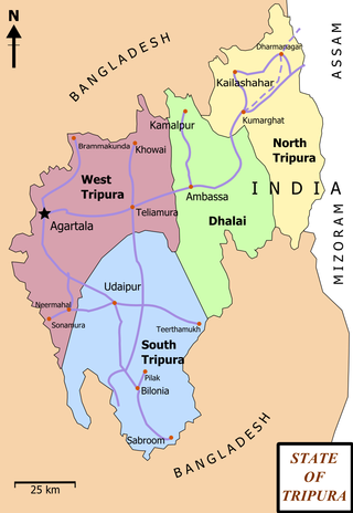
Ambassa is a census town located in the Indian state of Tripura a Municipal Council in Dhalai district. Ambassa is also the headquarters of the Dhalai district.
Khowai is a town located in the Indian state of Tripura and a Municipal Council in Khowai district. The city lies on the banks of Khowai river and hence from the river the city gets its name. It was originally settled upon by Upendranath Roy. Located near the Bangladesh border, Khowai has boundaries with Bangladesh on its entire southern part.

Udaipur, formerly known as Rangamati, is the third biggest urban area in the Indian state of Tripura. The town was a capital of the state during the reign of the Manikya Dynasty. It is famous for the Tripura Sundari temple also known as Tripureswari temple, one of the 51 Shakti Peethas.It is a Municipal Council in Gomati district & also the headquarters of Gomati district. Udaipur is about 51 km from Agartala, the capital of Tripura.
Morinda is a city with Municipal Council, near city of Rupnagar in Rupnagar District in the Indian state of Punjab. Morinda is an old town which is believed to trace its name from Mor Jats. It can be known as Moran and then Morinda.
Amarpur is a town and a Nagar Panchayat in Gomati district in the Indian state of Tripura. The City was named after King Amar Manikya. Amarpur is also the headquarters of Amarpur sub-division.
Belonia is a town and municipal council in South Tripura district, Tripura, India. It is also the headquarters of South Tripura District. It is linked with Agartala by National Highway 108A from Belonia to Jolaibari and via National Highway 8 from Jolaibari to Agartala. Belonia lies on the border with Bangladesh.

Dharmanagar or (Dhôrmônôgôr) is a town with a municipal council in the northeast of India. It is the administrative center for North Tripura district, located in the northernmost region of the state near the Assam border on the west and the India-Bangladesh border on the east. It is the second largest urban area in the state, which make it one of the important commercial centre. The juri river pass through the town.
Jogendranagar is a census town in West Tripura district in the Indian state of Tripura. Jogendranagar has the only railway station after Agartala railway station, in Agartala.
Kamalpur is a town and a Nagar Panchayat in Dhalai District in the Indian state of Tripura around 93 km from the state capital Agartala. It is the largest Sub-divisional town in Dhalai District.
Motipur is a town and a notified area in Muzaffarpur district. It is located 14 kilometres south of Mehsi in the Indian state of Bihar. In 2021, Motipur Nagar Panchayat was upgraded to Nagar Parishad.

Sahnewal is a city and a municipal council in Ludhiana district in the Indian state of Punjab. The city is situated on National Highway No. 44, between Khanna and Ludhiana.
Teliamura is a town and a Municipal Council in Khowai district in the Indian state of Tripura. It is on National Highway No. 08 of India. It is also the headquarters of the recently included sub-division of Teliamura. It is 45 km from Agartala, Capital of Tripura, 35 km from Khowai and 42 km from Ambassa.
Ashta is a city and a municipal council in Sangli district in the state of Maharashtra, India. It is located at 16.95°N 74.4°E. It has an average elevation of 567 metres (1860 ft). The name "Ashta" comes from the legend that Lord Shri Ram established eight (Asht) Lord Mahadev temples in this area. The city is divided into 19 wards for which elections are held every 5 years. The Ashta Municipal Council has the population of 37,105 of which 19,171 are males while 17,934 are females as per the report released by Census India 2011.

Kailashahar is the fourth largest urban area in the north eastern state of India, Tripura, located near northwest Bangladesh border. It is a Municipal council and the administrative center of the Unakoti district, this city is surrounded by unakoti hills and flows through Tripura's longest river, Manu.

Sepahijala District is a district of Tripura, India. This district was created in January 2012 when four new districts were established in Tripura, taking the number of districts in the state from four to eight. Part of the district was formed from the former district of West Tripura. The principal towns in the district are Bishalgarh, Bishramganj, Melaghar and Sonamura.
Santirbazar is a town and Municipal Council in South Tripura district, Tripura, India. It is linked with Agartala by National Highway 8 via Udaipur and Bishramganj to Sabroom.

Dasarahalli is a town and a city municipal council in Bangalore Urban district in the state of Karnataka, India

Mohanpur is a Municipal Council in Tripura, northeast India. It is the 10th largest town in the state and a subdivision of West Tripura district.

