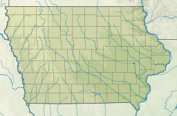
Rathbun Lake was constructed and is operated by the U.S. Army Corps of Engineers. Located at Chariton River mile marker 142, approximately 7 miles north of Centerville, Iowa, in Appanoose County, it is one of the largest lakes in Iowa. The lake was constructed to control flooding, provide recreation opportunities, abate stream pollution, fish and wildlife enhancement, and maintain minimum stream flow on the Chariton, Missouri, and Mississippi Rivers. The Chariton and South Fork of the Chariton River are the major sources of water flowing into Rathbun Lake.
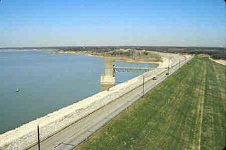
The construction of Rathbun Dam and Reservoir was authorized by the Flood Control Act of 1954 (Public Law 83-780). Construction of the dam and embankment began in September 1964. Most of the remains of the village of Griffinsville are underneath the lake.[1] The dam itself is rolled earthfill construction and is 10,129 feet long, 30 feet wide at the top, and rises 100 feet above the streambed. Operation as a multi-purpose unit began November 1969 and the top of multi-purpose pool (904 msl) was reached on October 10, 1970. Rathbun Lake was dedicated July 31, 1971, with President Richard Nixon being the keynote speaker.
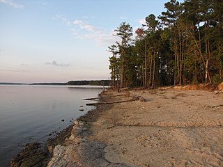
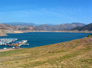
Camping, sightseeing, fishing, boating, picnicking and hunting are favorite activities on and near Rathbun Lake. The lake’s fish and wildlife resources provide sightseers, fishermen and hunters ample opportunities for their sports. Bald eagles, white-tailed deer, Canada geese, wild turkey, crappie, walleye, channel catfish and other wildlife can be found at Rathbun Lake. The size of the lake combined with the prevailing winds make Rathbun Lake one of the best sailing lakes in Iowa. One marina concession area, Rathbun Lake Marina (near the dam), provides a full line of marina services. Rathbun Lake is home to the Rathbun Yacht Club.
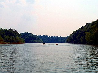
Boaters enjoying a sunset cruise on Rathbun Lake.
Eight parks have been developed for public recreation. Six are managed by the Corps of Engineers, and one state park is managed by the Iowa Department of Natural Resources. Recreation facilities include boat ramps, courtesy docks, campgrounds, picnic areas and playgrounds. Honey Creek State Park Resort opened in 2008 and is Iowa's first-ever state-run resort with more than a hundred guest rooms, an 18-hole golf course, and an indoor water park.
Rathbun Lake supplies the water treatment plant of Rathbun Regional Water Association (RRWA) which provides quality water to nearly 16,000 rural families, farms and communities in Iowa and Missouri. Average production at the plant during 2001 was 4.37 million gallons per day; however, the annual usage of the RRWA water system is equal to only 4 inches of Rathbun Lake water surface.
Jordan Lake State Recreation Area is a North Carolina state park spanning Chatham County, and Wake County North Carolina in the United States. It comprises 4,558 acres (18.45 km2) of woodlands along the shores of 13,940-acre (56 km2) Jordan Lake.
Lake Eufaula, sometimes referred to as Eufaula Lake, is a reservoir in Oklahoma. It is located on the Canadian River, 27 mi (43 km) upstream from its confluence with the Arkansas River and near the town of Eufaula. The lake covers parts of McIntosh County, Pittsburg, Haskell and Okmulgee counties and drains 47,522 square miles (123,080 km2). Water sources include the Canadian, North Fork Canadian and Deep Fork rivers. It is the largest-capacity lake in the state of Oklahoma with a volume of 2,099,000 acre-feet (2.589×10⁹ m3), a surface area of 102,000 acres (410 km2) and 600 miles (970 km) of shoreline.
Fort Peck Lake, or Lake Fort Peck, is a major reservoir in Montana, formed by the Fort Peck Dam on the Missouri River. The lake lies in the eastern prairie region of Montana approximately 140 miles (230 km) east of Great Falls and 120 miles (190 km) north of Billings, reaching into portions of six counties.
Lake Allatoona is a U.S. Army Corps of Engineers reservoir on the Etowah River in northwestern part of the State of Georgia. This reservoir is mostly in southeastern Bartow County and southwestern Cherokee County. A small portion is located in Cobb County near Acworth.
Lake Cumberland is a reservoir in Clinton, Pulaski, Russell, Wayne, and Laurel, counties in Kentucky. The primary reasons for its construction were a means for flood control and the production of hydroelectric power. Its shoreline measures 1,255 miles (2,020 km) and the lake covers 65,530 acres (265 km2) at the maximum power pool elevation. The reservoir ranks 9th in the U.S. in size, with a capacity of 6,100,000 acre-feet (7.5 km3) of water, enough to cover the entire Commonwealth of Kentucky with 3 inches (76 mm) of water. The main lake is 101 miles (163 km) long and over one mile (1.6 km) across at its widest point.
Skiatook Lake is a federally-owned and operated reservoir located in Osage County, Oklahoma, 4 miles (6.4 km) west of the town of Skiatook, 11 miles (18 km) east of Hominy, Oklahoma and about 18 miles (29 km) from Tulsa. The Skiatook Dam is located on Hominy Creek, 14 miles (23 km) upstream of the confluence of Hominy and Bird Creeks. The project purposes include flood control, water quality, water supply, recreation, and fish and wildlife management. The cities of Skiatook, Sand Springs, Sapulpa, and Tulsa use Skiatook Lake as a municipal water supply. Gentle rolling hills of Blackjack and Post Oak interspersed with Tallgrass prairie surround the lake. The lake is under the management of the U.S. Army Corps of Engineers, Tulsa District.
Lewis and Clark Lake is a 31,400 acre (130 km²) reservoir located on the border of the U.S. states of Nebraska and South Dakota on the Missouri River. The lake is approximately 25 miles (40 km) in length with over 90 miles (140 km) of shoreline and a maximum water depth of 45 feet (14 m). The lake is impounded by Gavins Point Dam and is managed by the U.S. Army Corps of Engineers, Omaha District.
Pine Flat Lake is an artificial lake or reservoir in the Sierra Nevada foothills of eastern Fresno County, California on the western north-south border to the Sierra- and Sequoia National Forests, about 30 mi (48 km) east of Fresno. The lake is managed by the U.S. Army Corps of Engineers (USACE) and is open to boaters, campers & hikers.
Canyon Lake is a reservoir on the Guadalupe River in the Texas Hill Country in the United States. Canyon Lake is a U.S. Army Corps of Engineers reservoir formed on the Guadalupe River in Comal County by Canyon Dam, which is located about sixteen miles northwest of New Braunfels. The dam, lake, and all adjacent property are managed by the U.S. Army Corps Of Engineers. Water rights, waste water treatment, and hydroelectric generating facilities are managed by the Guadalupe-Blanco River Authority. Construction of the dam began in 1958 and was completed in 1964. The reservoir serves to provide flood control and water supply for the communities downstream from the dam. The lake is also a popular recreational destination.
Perry Lake is a US Army Corps of Engineers operated reservoir in northeast Kansas. Its primary purposes are flood control, water reserve for nearby areas and regional recreation. The lake is approximately 11,150 acres (45 km²) in size, with over 160 miles (260 km) of shoreline. Perry Lake's full multi-purpose pool elevation is 891.5 feet (271.7 m) above sea level. Perry Lake is located about 40 miles (64 km) west of Kansas City, just northwest of Lawrence, Kansas. Its close proximity to Kansas City, Lawrence, and the state capitol, Topeka, make it a very popular destination, with the nickname "Paradise on the Plains".
Kerr Lake /kɑr/ is a reservoir along the border of the U.S. states of North Carolina and Virginia. It is impounded by the John H. Kerr Dam, constructed between 1947 and 1952 to produce hydroelectricity and to provide flood control. Kerr Lake is owned by the US Army Corps of Engineers, and is the largest reservoir in Virginia. It is located in parts of Vance, Granville, and Warren counties in North Carolina, and Mecklenburg, Charlotte, and Halifax counties in Virginia. At its maximum capacity, it is one of the largest reservoirs in the Southeastern United States, covering approximately 50,000 acres (200 km2) and bordered by over 850 miles (1,370 km) of shoreline. The lake is named for Congressman John H. Kerr of North Carolina, who supported the original creation of the lake.
The Rough River Lake is a Y-shaped reservoir located in Breckinridge, Hardin, and Grayson counties in Kentucky, about 70 miles southwest of Louisville. This lake was created by the building of a dam, begun in 1955 and completed in 1961, 89.3 miles above the connection between the Rough River and the Green River. The land and water, along with the wildlife, fisheries, and recreational activities, are all managed under the cooperation of the U.S. Army Corps of Engineers and the Commonwealth of Kentucky. A primary attraction is Rough River Dam State Resort Park.
Lake Shelbyville is a reservoir located in Shelby County, Illinois and Moultrie County, Illinois created by damming the Kaskaskia River at Shelbyville, Illinois. The lake's normal surface pool is 11,100 acres (44.9 km2) at an elevation of 183 meters (600.4 ft). The area that surrounds the lake is the Shelbyville State Fish and Wildlife Area. The lake is managed by the United States Army Corps of Engineers, and the wildlife is managed by the Illinois Department of Natural Resources.
El Dorado Lake is a reservoir on the Walnut River 0.5 miles (0.80 km) northeast of El Dorado in the Flint Hills region of Kansas. Built and managed by the U.S. Army Corps of Engineers, it is used for flood control, recreation, and water supply. El Dorado State Park is located on its shore.
Grapevine Lake is a reservoir located in the North Texas region, about 20 mi (32 km) northwest of Dallas and northeast of Fort Worth. It was impounded in 1952 by the US Army Corps of Engineers when they dammed Denton Creek, a tributary of Trinity River.
Lost Creek Lake is a reservoir located on the Rogue River in Jackson County, Oregon, United States. The lake is impounded by William L. Jess Dam which was constructed by the U.S. Army Corps of Engineers in 1977 for flood control and fisheries enhancement. The lake and dam were the first completed elements of the multi-purpose Rogue River Basin Project, consisting of Lost Creek Lake, Applegate Lake and the Elk Creek project. The lake is located approximately 27 miles (43 km) northeast of Medford.
Hugo Lake is manmade lake located 7 miles (11 km) east of Hugo, in Choctaw County, Oklahoma, United States. It is formed by Hugo Lake Dam on the Kiamichi River 18 miles (29 km) upstream from the Red River. The dam is visible from U.S. Route 70, which crosses its spillway just west of Sawyer. Lake Hugo features approximately 110 miles (180 km) of shoreline and covers over 13,250 acres (53.6 km2), or 20 square miles (52 km2). Its normal pool elevation is 404.5 feet (123.3 m) above sea level and its normal storage capacity is 157,600 acre-feet (194,400,000 m3). At flood stage its elevation is at 437.5 feet (133.4 m) above sea level and it is capable of storing 966,700 acre-feet (1.1924×10⁹ m3) of flood waters. The lake's primary functions are to provide flood control, water storage, and recreational opportunities.
Bluestone Wildlife Management Area is a wildlife management area in southern West Virginia surrounding Bluestone Lake and the New River. The section of the lake from just upstream of the Bluestone River to Bluestone Dam is in Bluestone State Park; the rest of the lake in West Virginia basin comprises Bluestone WMA. All together, the WMA comprises 18,019 acres (72.92 km2) of land and water.
Long Branch State Park is a public recreation area occupying 1,828 acres (740 ha) adjacent to the Long Branch Reservoir in Macon County, Missouri. The state park consists of three units located some two miles west of Macon, Missouri on U.S. Highway 36.
Honey Creek State Park is located in Appanoose County, Iowa. The park has a hunting unit, a resort, and a fish hatchery.
This page is based on this Wikipedia article Text is available under the CC BY-SA 4.0 license; additional terms may apply. Images, videos and audio are available under their respective licenses.