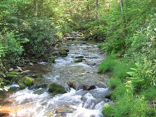
Rauchtown Run, named Rauchtown Creek on United States Geological Survey maps, is a tributary of the West Branch Susquehanna River in Clinton and Lycoming Counties, Pennsylvania, in the United States.

Rauchtown Run, named Rauchtown Creek on United States Geological Survey maps, is a tributary of the West Branch Susquehanna River in Clinton and Lycoming Counties, Pennsylvania, in the United States.
Rauchtown Run flows through the eastern portions of Clinton County and into the southwestern corner of Lycoming County where it sinks underground in Limestone Township and joins Antes Creek at the village of Oriole.
Beginning in Bastress Township, Antes Creek sinks underground at the village of Collomsville, picking up McMurrin Run and Rattling Camp Run while underneath the surface. After receiving Rauchtown Run at Oriole, it emerges above ground at Nippenose Spring in Limestone Township before joining the West Branch Susquehanna River near Jersey Shore. Antes Creek was historically known as Nippenose Creek. [1]
Nippenose is likely derived from a Lenape term "Nipeno-wi", meaning "like the summer." [2] The name "Antes Creek" honors Lt Colonel John Henry Ante, after whom nearby Fort Antes was also named. [3] Other variant names include: Sunken Creek, Antis Creek and Rauch Creek. [1] [4]
The total length of Rauchtown Run and Antes Creek is 9.4 miles (15.1 km). [5]

Lycoming County is a county in the Commonwealth of Pennsylvania. As of the 2020 census, the population was 114,188. Its county seat is Williamsport. The county is part of the Central Pennsylvania region of the state.

Bastress Township is a township in Lycoming County, Pennsylvania, United States. The population was 528 at the 2020 census. It is part of the Williamsport, Pennsylvania Metropolitan Statistical Area.

Jersey Shore is a borough in Lycoming County, Pennsylvania, United States. It is on the West Branch Susquehanna River, 15 miles (24 km) west by south of Williamsport. It is part of the Williamsport, Pennsylvania Metropolitan Statistical Area. In the past, Jersey Shore held farms, railroad shops, cigar factories, a foundry, and a large silk mill. The population was 4,158 at the 2020 census.

Limestone Township is a township in Lycoming County, Pennsylvania, United States. The population was 1,968 at the 2020 census. It is part of the Williamsport Metropolitan Statistical Area.

Nippenose Township is a township in Lycoming County, Pennsylvania, United States. The population was 662 at the 2020 census. It is part of the Williamsport, Pennsylvania Metropolitan Statistical Area.

Porter Township is a township in Lycoming County, Pennsylvania, United States. The population was 1,535 at the 2020 census. It is part of the Williamsport Metropolitan Statistical Area.

Susquehanna Township is a township in Lycoming County, Pennsylvania, United States. The population was 972 at the 2020 census. It is part of the Williamsport Metropolitan Statistical Area.

Washington Township is a township in Lycoming County, Pennsylvania, United States. The population was 1,769 at the 2020 census. It is part of the Williamsport Metropolitan Statistical Area.

The West Branch Susquehanna River is one of the two principal branches, along with the North Branch, of the Susquehanna River in the Northeastern United States. The North Branch, which rises in upstate New York, is generally regarded as the extension of the main branch, with the shorter West Branch being its principal tributary.

Lycoming Creek is a 37.5-mile-long (60.4 km) tributary of the West Branch Susquehanna River located in Tioga and Lycoming counties in Pennsylvania in the United States.

White Deer Hole Creek is a 20.5-mile (33.0 km) tributary of the West Branch Susquehanna River in Clinton, Lycoming and Union counties in the U.S. state of Pennsylvania. A part of the Chesapeake Bay drainage basin, the White Deer Hole Creek watershed drains parts of ten townships. The creek flows east in a valley of the Ridge-and-valley Appalachians, through sandstone, limestone, and shale from the Ordovician, Silurian, and Devonian periods.

The Great Island Path was a major Native American trail in the U.S. state of Pennsylvania that ran from the village of Shamokin along the right bank of the West Branch Susquehanna River north and then west to the Great Island.

The West Branch Susquehanna Valley of central Pennsylvania, United States, in the Ridge-and-valley Appalachians, is the low-lying area draining into the West Branch Susquehanna River southeast of the Allegheny Front, northeast of the Bald Eagle Valley, southwest of the Wyoming Valley and north of the water gap formed between Shamokin Mountain and Montour Ridge.

This article details a history of Lycoming County, Pennsylvania.
Fort Antes was a stockade surrounding the home of Colonel John Henry Antes, built circa 1778 in Revolutionary Pennsylvania in the United States. The fort was built under the direction of Colonel Antes, who was a member of the Pennsylvania militia. It was on the east side of Antes Creek, overlooking and on the left bank of the West Branch Susquehanna River on a plateau in Nippenose Township south of modern day Jersey Shore in western Lycoming County. The local militia held the fort for a short period of time until it was ordered to abandon Fort Antes during the Big Runaway by Colonel Samuel Hunter. Despite being abandoned and attempts by the attacking British forces to burn it down, Fort Antes was one of only two structures in the valley to survive the Big Runaway.
Rauchtown may refer to:
Oval is a census-designated place (CDP) in Limestone Township, Lycoming County, Pennsylvania, United States. As of the 2010 census, it had a population of 361. Oval is not a separately incorporated community, but is a part of Limestone Township.

Rauchtown is a census-designated place in Crawford Township, Clinton County, and a small portion in Limestone Township, Lycoming County, in the U.S. state of Pennsylvania. As of the 2010 census the population was 726.
41°11′20″N77°14′28″W / 41.1888°N 77.2412°W