Rauenkopf

Last updated
Rauenkopf
Rauchenkopf
Wildsee Seefeld 01.jpg
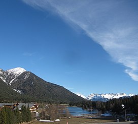
The Rauenkopf (left) with the lake of Wildsee in the foreground
Highest point
Elevation 2,011  m (AA) [1]
Coordinates 47°18′30″N11°13′41″E / 47.30833°N 11.22806°E / 47.30833; 11.22806
Geography
Parent range Karwendel

The Rauenkopf, also Rauchenkopf, is a mountain northeast of Reith bei Seefeld in the Karwendel Alps in the Austrian state of Tyrol. It is 2,011 metres high. [2]

Ascent

There is no marked route to the top. However a mountain path to the Reither Spitze, known as the Reither Spitzsteig, passes by 250 metres northwest of the summit. [2]

Related Research Articles

<span class="mw-page-title-main">Karwendel</span> Mountain range of the Northern Limestone Alps

The Karwendel is the largest mountain range of the Northern Limestone Alps. It is located on the Austria–Germany border. The major part belongs to the Austrian federal state of Tyrol, while the adjacent area in the north is part of Bavaria, Germany. Four chains stretch from west to east; in addition, there are a number of fringe ranges and an extensive promontory (Vorkarwendel) in the north.

<span class="mw-page-title-main">Seefeld in Tirol</span> Place in Tyrol, Austria

Seefeld in Tirol is an old farming village, now a major tourist resort, in Innsbruck-Land District in the Austrian state of Tyrol with a local population of 3,312. The village is located about 17 km (11 mi) northwest of Innsbruck on a plateau between the Wetterstein mountains and the Karwendel on a historic road from Mittenwald to Innsbruck that has been important since the Middle Ages. It was first mentioned in 1022 and since the 14th century has been a pilgrimage site, benefiting not only from the visit of numerous pilgrims but also from its stacking rights as a trading station between Augsburg and the Venice. Also since the 14th century, Tyrolean shale oil has been extracted in the area. Seefeld was a popular holiday resort even before 1900 and, since the 1930s, has been a well known winter sports centres and amongst the most popular tourist resorts in Austria. The municipality, which has been the venue for several Winter Olympics Games, is the home village of Anton Seelos, the inventor of the parallel turn.

Leutasch is a municipality in the northern part of the district Innsbruck-Land in the Austrian state of Tyrol about 30 km northwest of Innsbruck and 10 km northwest of Seefeld in Tirol

<span class="mw-page-title-main">Langenrohr</span> Place in Lower Austria, Austria

Langenrohr is a municipality in the district of Tulln in Lower Austria, Austria. The municipality has 2309 inhabitants as of 1 January 2013.

<span class="mw-page-title-main">Reiter Alpe</span>

The Reiter Alpe is a mountain range of the Berchtesgaden Alps, named after the village Reit. it is located on the German–Austrian border in Bavaria, Germany, and Salzburg, Austria.

<span class="mw-page-title-main">European route E533</span> Road in trans-European E-road network

E 533 is a European B class road in Germany and Austria, connecting the cities Munich — Garmisch-Partenkirchen — Mittenwald — Seefeld in Tirol — Innsbruck.

<span class="mw-page-title-main">Erlspitze Group</span>

The Erlspitze Group, also called the Seefeld Group, is the southwesternmost side range of the Austrian part of the Karwendel mountains in the Alps. It forms a horseshoe-shaped highland around the valley of Eppzirler Tal and is joined in the south to the Nordkette by the Erl Saddle (Erlsattel) near Solsteinhaus. It is bounded in the west by the Seefeld Basin, in the east by the valleys of the Gleirschtal and the Großes Kristental; its forested northern foothills reach as far as Scharnitz.

<span class="mw-page-title-main">Scharnitz Pass</span>

The Scharnitz Pass is a narrow section of the upper Isar valley in the Northern Limestone Alps. It lies at a height of about 955 m on the Austro-German border between the states of Bavaria and Tyrol. Its name derives from the village of Scharnitz immediately to the south.

<span class="mw-page-title-main">Reither Spitze</span> Austrian mountain

The Reither Spitze is a mountain in the Karwendel in the Austrian federal state of Tyrol that, thanks to its location at the southwestern end of the Erlspitze Group, is particularly well known for its great views of the surrounding area from its summit. Its name is derived the village of Reith bei Seefeld, which lies at its southwestern foot.

<span class="mw-page-title-main">Schlossbach (Inn)</span> River in Tyrol, Austria

The Schlossbach is a river of Tyrol, Austria, a left tributary of the Inn.

<span class="mw-page-title-main">Wildsee (Seefeld)</span>

The Wildsee, occasionally also called the Seefelder See, is a lake near the Austrian resort of Seefeld in Tirol at the foot of the Gschwandtkopf. It has an area of 6.1 hectares and a maximum depth of 5.1 metres. The majority of the lake belongs to the municipality of Seefeld, its south and west shores are part of Reith bei Seefeld.

The Brunstkopf is a mountain immediately north of Zirl in the Karwendel Alps in the Austrian state of Tyrol. It is 1,719 metres high.

<span class="mw-page-title-main">Nördlinger Hut</span> Alpine Club hut in Tyrol, Austria

The Nördlinger Hut is an Alpine Club hut belonging to the German Alpine Club that is situated at a height of 2,238 m (AA) south of the summit of the Reither Spitze in the Austrian state of Tyrol. It is thus the highest refuge hut in the entire Karwendel range. It is located in the westernmost part of the Karwendel Alps, the Erlspitze Group, above the village and ski resort of Seefeld. From the hut there are expansive views over the Stubai Alps, the Inn valley and the Wetterstein Mountains.

<span class="mw-page-title-main">Seefelder Spitze</span>

The Seefelder Spitze is a mountain east of Seefeld in Tirol in the Karwendel Alps in the Austrian state of Tyrol. It is 2,221 metres high and there is a summit cross at the top.

<span class="mw-page-title-main">Härmelekopf</span>

The Härmelekopf is a mountain northeast of Seefeld in Tirol in the Karwendel Alps in the Austrian state of Tyrol. It is 2,224 metres high.

<span class="mw-page-title-main">Seefeld Plateau</span>

The Seefeld Plateau is a montane valley and basin landscape in the North Tyrolean Limestone Alps about 500 metres above the Inn valley in the Austrian state of Tyrol. The plateau covers the valley basin around the villages of Seefeld in Tirol and Scharnitz as well as the valley of Leutaschtal.

<span class="mw-page-title-main">Gschwandtkopf</span>

The Gschwandtkopf is a mountain south of the ski resort of Seefeld in Tirol in the Austrian state of Tyrol. It is 1,495 metres high. There are two inns at the summit: the Ötzi Hut and the Sonnenalm.

<span class="mw-page-title-main">Zirler Berg</span> Mountain in Tyrol, Austria

The Zirler Berg near Zirl in the Austrian federal state of Tyrol is a mountain, 1,057 m (AA) high, in the Karwendel Alps, a western part of the Northern Limestone Alps. It is a southern foothill of the Reither Spitze (2,374 m) and is known mainly because the Seefelder Straße (B 177) on its southern slopes climbs through 388 metres in a distance of less than 4 kilometres from Zirl in the Inn valley to Leithen on the Seefeld Plateau.

<span class="mw-page-title-main">Seefeld Saddle</span>

The Seefeld Saddle is a saddle and mountain pass, 1,185 m (AA), in the Northern Limestone Alps in the Austrian federal state of Tyrol. Two major transport routes run over it: the Seefelder Straße (B 177) and the Mittenwald Railway. On the Seefeld Plateau north of the saddle lies the village and ski resort of Seefeld in Tirol.

Austriadraco is a genus of pterosaur living during the Late Triassic in the area of present Austria. Its only species—Austriadraco dallavecchiai—was previously attributed to Eudimorphodon, and its closest relatives may have been Eudimorphodon or Arcticodactylus.

References

  1. Bundesamt für Eich- und Vermessungswesen (BEV): Topographic map of Austria at AMAP online
  2. 1 2 Seefeld Leutasch 1:25,000 hiking map, Wanderland-Verlag, 4th edn., 2011.