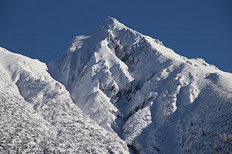
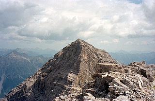
The Hochvogel is a 2,592-metre-high (8,504 ft) mountain in the Allgäu Alps. The national border between Germany and Austria runs over the summit. Although only the thirteenth highest summit in the Allgäu Alps, the Hochvogel dominates other parts of Allgäu Alps and the other ranges in the immediate neighbourhood. This is due to the fact that the majority of the higher peaks are concentrated in the central and western part of the Allgäu Alps. The Hochvogel stands on its own in the eastern part of the mountain group; the nearest neighbouring summits are 200 to 300 metres lower. Experienced climbers can ascend the summit on two marked routes.

The Krottenspitze (2,551m) is a mountain in the Allgäu Alps. It is one of the few rocky summits of the main ridge that is visible from Oberstdorf.
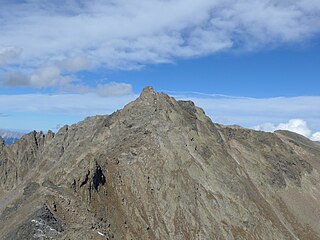
The Lizumer Reckner is, at 2,886 m above sea level (AA), the highest mountain in the Tux Alps in the Austrian state of Tyrol.
The Urbeleskarspitze is a 2,632-metre-high mountain peak in the Allgäu Alps. It lies within Austria in the state of Tyrol and is the fifth-highest summit in the Allgäu Alps and the second-highest peak in the Hornbach chain. Its neighbours in the Hornbach chain are the Bretterspitze to the southwest and the Zwölfer Spitze to the northeast.
The Erlspitze Group, also called the Seefeld Group, is the southwesternmost side range of the Austrian part of the Karwendel mountains in the Alps. It forms a horseshoe-shaped highland around the valley of Eppzirler Tal and is joined in the south to the Nordkette by the Erl Saddle (Erlsattel) near Solsteinhaus. It is bounded in the west by the Seefeld Basin, in the east by the valleys of the Gleirschtal and the Großes Kristental; its forested northern foothills reach as far as Scharnitz.

The Hintere Brandjochspitze is a summit roughly 200 metres northwest of the Vordere Brandjochspitze in the Nordkette range above Innsbruck. It rises above its "forward" neighbour by around 40 metres.
The Rauenkopf, also Rauchenkopf, is a mountain northeast of Reith bei Seefeld in the Karwendel Alps in the Austrian state of Tyrol. It is 2,011 metres high.

The Nördlinger Hut is an Alpine Club hut belonging to the German Alpine Club that is situated at a height of 2,238 m (AA) south of the summit of the Reither Spitze in the Austrian state of Tyrol. It is thus the highest refuge hut in the entire Karwendel range. It is located in the westernmost part of the Karwendel Alps, the Erlspitze Group, above the village and ski resort of Seefeld. From the hut there are expansive views over the Stubai Alps, the Inn valley and the Wetterstein Mountains.
The Seefelder Spitze is a mountain east of Seefeld in Tirol in the Karwendel Alps in the Austrian state of Tyrol. It is 2,221 metres high and there is a summit cross at the top.

The Härmelekopf is a mountain northeast of Seefeld in Tirol in the Karwendel Alps in the Austrian state of Tyrol. It is 2,224 metres high.

The Hohe Munde is a 2,662-metre-high (8,734 ft) mountain at the eastern end of the Mieming Chain in the Austrian state of Tyrol. It has two peaks: the west top (2,662 m) and the east top or Mundekopf (2,592 m).

The Schlicker Seespitze, at 2,804 m (AA), is the highest peak in the Kalkkögel range in Austria's Stubai Alps, and the southwestern cornerstone of the chain. This mountain, known for being extremely prone to landslides, is a good observation point. It is located near the village of Schlick.

The Erlspitze, at 2,405 m (AA), is the highest mountain of the range to which it gives its name in the southeastern corner of the Karwendel Alps. Its pyramid-shaped summit makes it a good observation peak north of the Erl Saddle and the Solsteinhaus mountain hut.

The Freiungspitzen (plural) are a group of 3 peaks in the Erlspitze Group in the Karwendel Alps on the territory of the Austrian municipality of Zirl. The highest summit, the west top, has a height of 2,332 m (AA), the middle top is 2,322 m (AA) and the east top is 2,302 m (AA).

The Solsteinhaus is an Alpine Club hut belonging to the Austrian Alpine Club located at a height of 1,806 m (AA) on the Erl Saddle (Erlsattel) between the mountains of the Nordkette and Erlspitze Group. It was opened in 1914 and totally renovated in 2007. It lies in the western Karwendel Alps in the state of Tyrol not far from the state capital of Innsbruck. Due to its central location and the numerous tour options it offers, the hut is a base for climbers taking part in tours of several days long, as well as a starting point for summit attempts. In addition the hut is a popular destination for hikers who can easily do a day tour to the hut. In winter the hut is closed, but there is a winter room for ski tourers. During safe avalanche conditions, high Alpine ski tours can be undertaken to the surrounding summits; but these all require good experience.

The Zirler Berg near Zirl in the Austrian federal state of Tyrol is a mountain, 1,057 m (AA) high, in the Karwendel Alps, a western part of the Northern Limestone Alps. It is a southern foothill of the Reither Spitze (2,374 m) and is known mainly because the Seefelder Straße (B 177) on its southern slopes climbs through 388 metres in a distance of less than 4 kilometres from Zirl in the Inn valley to Leithen on the Seefeld Plateau.

The Bretterspitze is a 2,608-metre-high summit in the Austrian state of Tyrol. It is part of the Hornbach chain in the Allgäu Alps. Its neighbouring peaks in the Hornbach chain are the Gliegerkarspitze to the west and the Urbeleskarspitze to the northeast. The broad summit block of the Bretterspitze is made of main dolomite.
The Zwieselbacher Rosskogel is a double peak in the northern Stubai Alps in the Austrian state of Tyrol. Its summit offers a sweeping panorama to the north because no other higher mountains impede the view. To the south, by contrast, the view is restricted by higher summits in the Stubai Alps. The first well known ascent took place on 23 August 1881 by Ludwig Purtscheller accompanied by chamois hunter Franz Schnaiter from Zirl.

The Zettenkaiser is a 1,968 m high mountain with a summit cross in the Kaiser Mountains (Kaisergebirge) in the Northern Limestone Alps in Austria. It rises to the west of the almost 150-metre-higher Scheffauer, from which it is separated by a col. It is one of the more rarely visited summits in the Kaiser. There are great views south to the main chain of the Alps, north to the Zahmer Kaiser and west into the Inn Valley; to the east at the foot of the summit is the rock needle known as the Kaindlnadel and then the mighty Scheffauer.

The Schaufelspitze is a mountain, 2,306 m (AA) in the Sonnjoch Group in the eastern Karwendel between Sonnjoch and the Bettlerkarspitze.