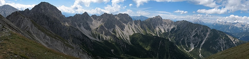
The Erlspitze Group (German: Erlspitzgruppe), also called the Seefeld Group, is the southwesternmost side range of the Austrian part of the Karwendel mountains in the Alps. It forms a horseshoe-shaped highland around the valley of Eppzirler Tal and is joined in the south to the Nordkette by the Erl Saddle (Erlsattel) near Solsteinhaus. It is bounded in the west by the Seefeld Basin, in the east by the valleys of the Gleirschtal and the Großes Kristental; its forested northern foothills reach as far as Scharnitz.
Unlike the four main ranges of the Karwendel, the Erlspitze Group is made of Main Dolomite. Typical of this rock are bizarre weathering forms, like towers, pinnacles and sharply formed arêtes as well as rock arches and caves as a consequence of the rapid erosion of individual rock strata.
Two alpine club huts act as bases for tours in the area of the Erlspitze Group: in the west is the Nördlinger Hut and, in the south, is the Solsteinhaus. In the northern part of the Erlspitze Group are two huts open in summer: the Oberbrunnalm and, in the Eppzirler Tal, the Eppzirler Alm.
The Karwendel is the largest mountain range of the Northern Limestone Alps. It is located on the Austria–Germany border. The major part belongs to the Austrian federal state of Tyrol, while the adjacent area in the north is part of Bavaria, Germany. Four chains stretch from west to east; in addition, there are a number of fringe ranges and an extensive promontory (Vorkarwendel) in the north.
The Bezirk Innsbruck-Land is an administrative district (Bezirk) in Tyrol, Austria. It encloses the Statutarstadt Innsbruck, and borders Bavaria (Germany) in the north, the district Schwaz in the east, South Tyrol in Italy to the south, and the district of Imst in the west.
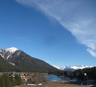
Seefeld in Tirol is an old farming village, now a major tourist resort, in Innsbruck-Land District in the Austrian state of Tyrol with a local population of 3,312. The village is located about 17 km (11 mi) northwest of Innsbruck on a plateau between the Wetterstein mountains and the Karwendel on a historic road from Mittenwald to Innsbruck that has been important since the Middle Ages. It was first mentioned in 1022 and since the 14th century has been a pilgrimage site, benefiting not only from the visit of numerous pilgrims but also from its stacking rights as a trading station between Augsburg and the Venice. Also since the 14th century, Tyrolean shale oil has been extracted in the area. Seefeld was a popular holiday resort even before 1900 and, since the 1930s, has been a well known winter sports centres and amongst the most popular tourist resorts in Austria. The municipality, which has been the venue for several Winter Olympics Games, is the home village of Anton Seelos, the inventor of the parallel turn.
The Wetterstein mountains, colloquially called Wetterstein, is a mountain group in the Northern Limestone Alps within the Eastern Alps, crossing the Austria–Germany border. It is a comparatively compact range located between Garmisch-Partenkirchen, Mittenwald, Seefeld in Tirol and Ehrwald along the border between Germany (Bavaria) and Austria (Tyrol). Zugspitze, the highest peak is at the same time the highest mountain in Germany.
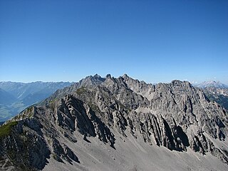
The Arnspitze Group is a free-standing mountain chain in Austrian and Germany, in the states of Tyrol and Bavaria, between Seefeld in Tirol and Mittenwald, and between the Leutasch valley in the west and the Isar valley near Scharnitz in the east. In the literature, the Arnspitze Group is classed as part of the Wettersteingebirge. The majority of the group belongs to Tyrol, a northeastern part of the chain lies in Bavaria. The border between Bavaria and Tyrol runs over the summit of the Große Arnspitze.
The Mieming(er) Range, Mieminger Chain or Mieminger Mountains, is a mountain range of the Northern Limestone Alps in the Eastern Alps. It is located entirely in Austria within the state of Tyrol. This sub-group is somewhat in the shadows of its more famous neighbour, the Wetterstein to the north. Whilst the region around the Coburger Hut and the lakes of Seebensee and Drachensee in the west and the Hohe Munde in the extreme east receive large numbers of visitors, the less developed central area remains very quiet. The Hohe Munde is also a popular and challenging ski touring destination.
The Mittenwald Railway, popularly known as the Karwendelbahn, is a railway line in the Alps in Austria and Germany. It connects Innsbruck via Seefeld and Mittenwald to Garmisch-Partenkirchen.
The Villgraten Mountains or Deferegg Alps, also called the Defreggen Mountains are a subgroup of the Austrian Central Alps within the Eastern Alps of Europe. Together with the Ankogel Group, the Goldberg Group, the Glockner Group, the Schober Group, the Kreuzeck Group, the Granatspitze Group, the Venediger Group and the Rieserferner Group, the Villgraten Mountains are part of the major mountain range, the High Tauern. Their highest summit is the Weiße Spitze with a height of 2,962 m above sea level (AA).
The Nordkette, also variously called the North Chain, Northern Range, rarely the Inn Valley Range or Inn Valley Chain (Inntalkette), is a range of mountains just north of the city of Innsbruck in Austria. It is the southernmost of the four great mountain chains in the Karwendel. To the west it is linked by the Erl Saddle to the Erlspitze Group, to the east via the Stempeljoch saddle to the Gleirsch-Halltal Range. To the south it is bounded by the Inn valley. Its highest summit is the Kleiner Solstein in the west of the range.
The Scharnitz Pass is a narrow section of the upper Isar valley in the Northern Limestone Alps. It lies at a height of about 955 m on the Austro-German border between the states of Bavaria and Tyrol. Its name derives from the village of Scharnitz immediately to the south.
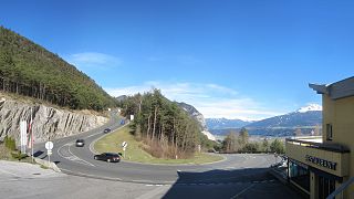
Seefelder Straße (B 177) is a 21.2 km long former federal road or Bundesstraße - now classified as a "priority road" or Straße mit Vorrang - in the Alps in the Austrian federal state of Tyrol. It links the Inn valley with Scharnitz and the Scharnitz Pass on the border with Germany, running past the Zirler Berg, over the Seefeld Saddle and past Seefeld. It is part of the E533 European route.
The Reither Spitze is a mountain in the Karwendel in the Austrian federal state of Tyrol that, thanks to its location at the southwestern end of the Erlspitze Group, is particularly well known for its great views of the surrounding area from its summit. Its name is derived the village of Reith bei Seefeld, which lies at its southwestern foot.
The Nördlinger Hut is an Alpine Club hut belonging to the German Alpine Club that is situated at a height of 2,238 m (AA) south of the summit of the Reither Spitze in the Austrian state of Tyrol. It is thus the highest refuge hut in the entire Karwendel range. It is located in the westernmost part of the Karwendel Alps, the Erlspitze Group, above the village and ski resort of Seefeld. From the hut there are expansive views over the Stubai Alps, the Inn valley and the Wetterstein Mountains.
The Seefeld Plateau is a montane valley and basin landscape in the North Tyrolean Limestone Alps about 500 metres above the Inn valley in the Austrian state of Tyrol. The plateau covers the valley basin around the villages of Seefeld in Tirol and Scharnitz as well as the valley of Leutaschtal.
The Erlspitze, at 2,405 m (AA), is the highest mountain of the range to which it gives its name in the southeastern corner of the Karwendel Alps. Its pyramid-shaped summit makes it a good observation peak north of the Erl Saddle and the Solsteinhaus mountain hut.
The Solsteinhaus is an Alpine Club hut belonging to the Austrian Alpine Club located at a height of 1,806 m (AA) on the Erl Saddle (Erlsattel) between the mountains of the Nordkette and Erlspitze Group. It was opened in 1914 and totally renovated in 2007. It lies in the western Karwendel Alps in the state of Tyrol not far from the state capital of Innsbruck. Due to its central location and the numerous tour options it offers, the hut is a base for climbers taking part in tours of several days long, as well as a starting point for summit attempts. In addition the hut is a popular destination for hikers who can easily do a day tour to the hut. In winter the hut is closed, but there is a winter room for ski tourers. During safe avalanche conditions, high Alpine ski tours can be undertaken to the surrounding summits; but these all require good experience.
The Zirler Berg near Zirl in the Austrian federal state of Tyrol is a mountain, 1,057 m (AA) high, in the Karwendel Alps, a western part of the Northern Limestone Alps. It is a southern foothill of the Reither Spitze (2,374 m) and is known mainly because the Seefelder Straße (B 177) on its southern slopes climbs through 388 metres in a distance of less than 4 kilometres from Zirl in the Inn valley to Leithen on the Seefeld Plateau.
The Seefeld Saddle is a saddle and mountain pass, 1,185 m (AA), in the Northern Limestone Alps in the Austrian federal state of Tyrol. Two major transport routes run over it: the Seefelder Straße (B 177) and the Mittenwald Railway. On the Seefeld Plateau north of the saddle lies the village and ski resort of Seefeld in Tirol.
The Hinterautal-Vomper Chain, also called the main chain of the Karwendel (Karwendelhauptkette), is the longest mountain chain in the Karwendel Alps in Austria. It has numerous peaks that reach heights of 2,500 m, including the highest summit of the Karwendel, the Birkkarspitze, and its neighbour, the three Ödkarspitzen. While long ridges radiate south and north from the western part of the main chain, with typical Karwendel cirques nestling between them, the eastern part of the chain has an almost 1,000 m high, solid rock face on the northern side, which is most striking at the Laliderer Wand. The main chain is divided into the Hinterautal chain (Hinterautalkette) in the west and the Vomper Chain (Vomperkette) in the east and runs through the Karwendel Alps from Scharnitz in the west to the village of Vomp in the east.
The Northern Karwendel Chain is the northernmost of the four great, largely parallel mountain chains in the Karwendel in the Alps. It is made from very pure Wetterstein limestone, which has its heart in the Karwendel and runs for a total length of c. 18 kilometres from Scharnitz in the northeast via Mittenwald to the Wörner, where it turns sharply east, until it finally ends west of the Johannestal valley. It has 25 main summits with an average height of 2,400 m. The highest peak is the Eastern Karwendelspitze. The boundary between Germany and Austria runs along the crest from the Brunnensteinspitze in the west to the Eastern Karwendelspitze in the east. The northwestern side is Bavarian, the southeastern flank is Tyrolean. The Northern Karwendel Chain should not be confused with the southernmost chain of the Karwendel, the Inn Valley Chain, which is known colloquially as the Nordkette or "North Chain" due to its location north of the city of Innsbruck.
This page is based on this Wikipedia article Text is available under the CC BY-SA 4.0 license; additional terms may apply. Images, videos and audio are available under their respective licenses.