
A cist is a small stone-built coffin-like box or ossuary used to hold the bodies of the dead. Examples can be found across Europe and in the Middle East. A cist may have been associated with other monuments, perhaps under a cairn or long barrow. Several cists are sometimes found close together within the same cairn or barrow. Often ornaments have been found within an excavated cist, indicating the wealth or prominence of the interred individual.

Harju County, is one of the fifteen counties of Estonia. It is situated in Northern Estonia, on the southern coast of the Gulf of Finland, and borders Lääne-Viru County to the east, Järva County to the southeast, Rapla County to the south, and Lääne County to the southwest. The capital and largest city of Estonia, Tallinn, is situated in Harju County. Harju County is the largest county in Estonia in terms of population, as almost half (45%) of the Estonia's population lives in Harju County.

Jõelähtme Parish is a rural municipality in Harju County, north-western Estonia. It had a population of 5,351 and an area of 210.86 km2 (81.41 sq mi), the population density is 25.3770/km2 (65.726/sq mi)

Naissaar is an island in Estonia. It is situated in the Gulf of Finland, northwest of the capital city Tallinn, and is administratively part of the Viimsi parish. The island covers an area of 18.6 square kilometres. It is 8 kilometres long and 3.5 kilometres wide, and lies about 8.5 kilometres from the mainland. The highest point on the island is Kunilamägi, which is 27 metres above sea level. The island consists predominantly of coniferous forest and piles of stones and boulders. In 2020, the island had a population of 17; in 2011 the island had 35 or so permanent residents and some summer residents. Administratively the island is divided into three villages: Lõunaküla (Storbyn), Tagaküla (Bakbyn), and Väikeheinamaa (Lillängin).
Tõnismägi is a 36-metre high hillock adjacent to Toompea hill in Tallinn, Estonia.

Mõigu is a subdistrict of the district of Kesklinn in Tallinn, the capital of Estonia. It is located on the northeastern side of Lake Ülemiste. It has a population of 377. Mõigu's former German name until 1918 was Moik, also spelled Moick.

Virumaa is a former independent county in Ancient Estonia. Now it is divided into Ida-Viru County or Eastern Vironia and Lääne-Viru County or Western Vironia. Vironians built many strongholds, like Tarwanpe and Agelinde.
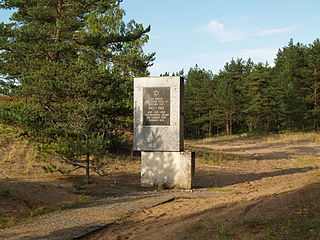
Kalevi-Liiva are sand dunes in Jõelähtme Parish in Harju County, Estonia. The site is located near the Baltic coast, north of the Jägala village and the former Jägala concentration camp. It is best known as the execution site of at least 6,000 Jewish and Roma Holocaust victims.

Karjamaa is a subdistrict in the district of Põhja-Tallinn, Tallinn, the capital of Estonia. It's located northwest of Kalamaja and east of Sitsi, main part is between Kopli, Tööstuse and Erika streets. Karjamaa also includes the Hundipea area and the Mine Harbour (Miinisadam) by the Tallinn Bay. Karjamaa has a population of 5,314.

Iru is a subdistrict in the district of Pirita, Tallinn, the capital of Estonia. It has a population of 35.

Pääsküla is a subdistrict in the district of Nõmme, Tallinn, the capital of Estonia. It covers an area of 5.95 km2 (2.30 sq mi) and has a population of 9,948, population density is 1,611.1/km2 (4,173/sq mi).

Kallavere is a village in Jõelähtme Parish, Harju County in northern Estonia. It's located about 17 km (11 mi) northeast of Tallinn, just east of Kallavere, the main part the town of Maardu. Kallavere village has a population of 142.
Koogi is a village in Jõelähtme Parish, Harju County in northern Estonia. It's lies on the left bank of the Jägala River. The Tallinn–Narva road passes Koogi and has an intersection with Jägala–Aegviidu–Käravete road. Koogi has 95 inhabitants (2005).
Liivamäe is a village in Jõelähtme Parish, Harju County in northern Estonia.
Ruu is a village in Jõelähtme Parish, Harju County in northern Estonia.
Võerdla is a village in Jõelähtme Parish, Harju County in northern Estonia.
Valgejõe is a village in Kuusalu Parish, Harju County, in northern Estonia. It is located on the crossing of the Tallinn–Narva road and the Valgejõgi River.
Katela is a village in Sõmeru Parish, Lääne-Viru County, in northeastern Estonia. The town is about 58 mi east of Tallinn. It is the Birth Place of Estonian Writer Jüri Parijõgi.

Rebala Heritage Reserve is a heritage conservation area in Jõelähtme Parish, east of Estonia's capital, Tallinn. It covers around 70 square kilometres and contains more than 300 archaeological remains, most of which are prehistoric stone-cist graves and cup-marked stones. Artifacts are on display in the Rebala Heritage Reserve Museum.

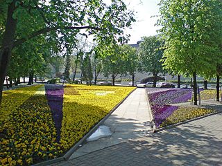
Tallinn Old Town is the oldest part of Tallinn, Estonia. Old Town of Tallinn has managed to wholly preserve its structure of medieval and Hanseatic origin. Old Town represents an exceptionally intact 13th century city plan. Since 1997, the area has been registered in the UNESCO World Heritage List. The old town is bordered by the Walls of Tallinn. Its area is 113 ha and there is a buffer zone of 2,253 ha.


