
Dunn County is a county in the U.S. state of Wisconsin. As of the 2010 census, the population was 43,857. Its county seat is Menomonie.

Chippewa County is a county located in the U.S. state of Wisconsin. It is named for the historic Chippewa people, also known as the Ojibwe, who long controlled this territory. As of the 2010 census, the population was 62,415. Its county seat is Chippewa Falls. The county was founded in 1845 from Crawford County, then in the Wisconsin Territory, and organized in 1853.

Barron County is a county located in the U.S. state of Wisconsin. As of the 2010 census, the population was 45,870. Its county seat is Barron. The county was created in 1859 and later organized in 1874.
Menomonie is a city in and the county seat of Dunn County in the western part of the U.S. state of Wisconsin. The city's population was 16,264 as of the 2010 census.
The University of Wisconsin–Eau Claire – Barron County is a branch campus to the University of Wisconsin–Eau Claire. It is located in Rice Lake, Wisconsin, and is a member of the University of Wisconsin System. As of the 2016–17 school year, there were 497 full and part-time students.

Tainter Lake is a small reservoir in north central Dunn County, Wisconsin, on the Red Cedar River at its confluence with the Hay River. The lake was created by a hydroelectric dam (about 3 miles downstream on the Red Cedar at Cedar Falls. The lake, a popular resort and fishing spot, has a surface area of approximately 2 square miles.

Lake Menomin is a reservoir on the Red Cedar River, in Dunn County, Wisconsin, USA.. Its name is derived from the Ojibwe name for this lake, Manoominikaani-zaaga'igan meaning "Abundant with Wild Rice Lake."

The Chippewa River in Wisconsin flows approximately 183 miles (294 km) through west-central and northwestern Wisconsin. It was once navigable for approximately 50 miles (80 km) of its length, from the Mississippi River, by Durand, northeast to Eau Claire. Its catchment defines a portion of the northern boundary of the Driftless Area. The river is easily accessible for bikers and pleasure seekers via the Chippewa River State Trail which follows the river from Eau Claire to Durand.

North American telephone area codes 715 and 534 are Wisconsin area codes covering most of the northern part of the state.

The Hay River is a tributary of the Red Cedar River in northwestern Wisconsin in the United States. It is about 50 mi (80 km) long. Via the Red Cedar and Chippewa Rivers, it is part of the Mississippi River watershed.
The Couderay River is a tributary of the Chippewa River in northwestern Wisconsin in the United States. Via the Chippewa River, it is part of the Mississippi River watershed. It flows for its entire length in Sawyer County. Its name is derived from the French "Rivière des Courte Oreilles".

The Eau Claire–Chippewa Falls metropolitan area refers loosely to the urbanized area along the Chippewa and Eau Claire Rivers, in west-central Wisconsin, with its primary center at Eau Claire and secondary centers at Chippewa Falls and Altoona.
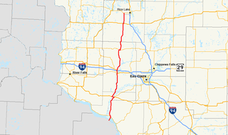
State Trunk Highway 25 is a state highway in Wisconsin, United States. The route serves local traffic in the western part of the state, connecting Durand, Menomonie and Barron. It is two-lane surface road with the exception of urban multilanes within Menomonie.
The Chippewa Valley is a valley in Wisconsin, US.

Old Abe State Trail is a 19.5-mile (31.4 km) paved multi-use rail trail in Chippewa County, Wisconsin, USA.

The Flambeau River is a tributary of the Chippewa River in northern Wisconsin, United States. The Chippewa is in turn a tributary of the upper Mississippi River. The Flambeau drains an area of 1,860 square miles (4,800 km2) and descends from an elevation of approximately 1,570 feet (480 m) to 1,060 feet (320 m) above sea level. The Flambeau is an important recreational destination in the region. It is notable among canoeists in the Midwest for outstanding canoe camping, including excellent scenery, fishing and whitewater. The river and its forks have a variety of possible trip lengths from short day outings, to overnight camping, to voyages of a week or more.

Chippewa River State Trail is a 26-mile urban-rural rail trail in western Wisconsin that follows the path of the Chippewa River. The trails runs from the spot of the confluence of the Chippewa with the Eau Claire River, at Phoenix Park in downtown Eau Claire, meeting up with the Red Cedar State Trail near Red Cedar, to the town of Durand. A former railroad corridor, the trail passes through a variety of habitat including wetlands, prairies, and sandstone bluff.
Knapp, Stout & Co. was a lumber company based in Menomonie, Wisconsin in the 19th and early 20th centuries. The company was established in 1846, when John Holly Knapp and William Wilson purchased half of interest in a lumber mill on the Red Cedar River from David Black; it was originally known as Black & Knapp. Later Andrew Tainter acquired a quarter-interest, and the company has become Knapp-Tainter Lumber Company. Henry Stout bought a quarter interest in the company in 1853, and its name became Knapp, Stout & Company. The company's location allowed it to control the lumber industry in the region, and by 1870 it controlled the logging industry in the Red Cedar River valley. In 1878, the company incorporated, and its official name became the Knapp, Stout & Co., Company. The company employed over 2,000 workers in the Menomonie area and produced 85 million board feet of lumber on average yearly from 1871 to 1896; its output made it the largest lumber company in the world. In the 1880s, the company expanded to sites along the Mississippi River, opening offices in Dubuque, Iowa, Read's Landing, Minnesota, and St. Louis. By the 1900s, the company had largely depleted its lumber supply; it closed many of its camps and dissolved early in the 20th century. The company sent out its last shipment of lumber on August 12, 1901.

There are a variety of schema for dividing Wisconsin into regions.
