
Prince Albert is the third-largest city in Saskatchewan, Canada, after Saskatoon and Regina. It is situated near the centre of the province on the banks of the North Saskatchewan River. The city is known as the "Gateway to the North" because it is the last major centre along the route to the resources of northern Saskatchewan. Prince Albert National Park is located 51 km (32 mi) north of the city and contains a wealth of lakes, forest, and wildlife. The city itself is located in a transition zone between the aspen parkland and boreal forest biomes. Prince Albert is surrounded by the Rural Municipality of Prince Albert No. 461, of which it is the seat, but is politically separate.
Melfort is a city in Saskatchewan, Canada, located approximately 95 kilometres (59 mi) southeast of Prince Albert, 172 kilometres (107 mi) northeast of Saskatoon and 280 kilometres (170 mi) north of Regina.

Meadow Lake is a city in the boreal forest of northwestern Saskatchewan, Canada. Its location is about 246 kilometres (153 mi) northeast of Lloydminster and 156 kilometres (97 mi) north of North Battleford. Founded as a trading post in 1799, it became a village in 1931 and a town in 1936. On November 9, 2009, it officially became Saskatchewan's 14th city.

The District of Saskatchewan was a regional administrative district of Canada's North-West Territories. It was formed in 1882 was later enlarged then abolished with the creation of the provinces of Saskatchewan and Alberta in 1905. Much of the area was incorporated into the province of Saskatchewan. The western part became part of Alberta, and the eastern part is now part of Manitoba.

Wakaw, Saskatchewan, is a town 90 kilometres (56 mi) northeast of Saskatoon and 66 kilometres (41 mi) south of Prince Albert. It is about halfway between the two cities and is served by Highway 2, Highway 41, and Highway 312. Wakaw is in hilly partially forested country east of the South Saskatchewan River. The area is part of the aspen parkland biome.
Landis is a village in the Canadian province of Saskatchewan within the Rural Municipality of Reford No. 379 and Census Division No. 13. The village is about 51 km (32 mi) south of Wilkie and about 128 km (80 mi) west from the City of Saskatoon on Highway 14. From 1907 to 1909, the post office at Section 23, Township 37, Range 18 west of the 3rd meridian, was known as Daneville. In 1925, Landis was a Canadian National Railway Station on the Grand Trunk Pacific Railway line.
Redwing, Saskatchewan, Canada, is a small community in the rural municipality (RM) of Buckland No. 491, located on Saskatchewan Highway 2. Redwing and Red Wing Terrace are both localities of Buckland No. 491. Red Wing Terrace is north of the locality of Green Acres on Green Acres Road and south of both Red Wing Terrace Road, and White Star. White Star is located on White Star Road, which is concurrent with Township Road 502 and Saskatchewan Highway 780.
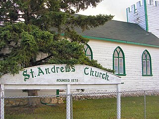
Halcro or St. Andrew's is a district in Saskatchewan, Canada north of St. Louis and south of Prince Albert. Adjacent to the South Saskatchewan River, it was initially settled by Anglo-Metis from Manitoba in the 1870s. Halcro is located in the aspen parkland biome.
Floral, Saskatchewan is an unincorporated community in the province of Saskatchewan, Canada.
Wilkie is a town in the Canadian province of Saskatchewan, located at Section 5, Township 40, Range 19, west of the 3rd Meridian. The town is at the junctions of Highways 14, 29, and 784.
Beaufield, previously known as Ednaburg, is an unincorporated community in Oakdale Rural Municipality No. 320, Saskatchewan, Canada. Located at Section 18, Township 32, Range 22, West of the 3rd Meridian. It had its first post office named Ednaburg from 1908-05-01 to 1913-08-01 upon which date it changed name to Beaufield. Ednaburg was located at Section 16, Township 32, Range 22, West of the 3rd Meridian. about 2 km east of Highway 21.

Saskatchewan, the middle of Canada's three prairie provinces, has an area of 588,276.09 square kilometres (227,134.67 sq mi) and population of 1,150,632, mostly living in the southern half of the province.

Duck Lake is a town in the boreal forest of central Saskatchewan, Canada. Its location is 88 kilometres (55 mi) north of Saskatoon and 44 kilometres (27 mi) south of Prince Albert on Highway 11, in the Rural Municipality of Duck Lake No. 463. Immediately to the north of Duck Lake is the south block of the Nisbet Provincial Forest.
The history of Saskatoon began with the first permanent non-indigenous settlement of Saskatoon, Saskatchewan, Canada, in 1883 when Toronto Methodists, wanting to escape the liquor trade in that city, decided to set up a "dry" community in the rapidly growing prairie region. As of 1882 this area was a part of the provisional district named Saskatchewan, North-West Territories (NWT). Their organization, the Temperance Colonization Society, first examined this area in 1882 and found that it would make an excellent location to found their community based on the ideals of the temperance movement; Saskatoon traditionally considers 1882 its founding year and thus marked its centennial in 1982. The settlers, led by John Neilson Lake, arrived on the site of what is now Saskatoon by traveling by railway from Ontario to Moose Jaw, Assiniboia, NWT, and then completing the final leg via horse-drawn cart. The plan for the Temperance Colony soon failed as the group was unable to obtain a large block of land within the community. Nonetheless, John Lake is commonly identified as the founder of Saskatoon; a public school, a park and two streets are named after him.
Rose Valley is a town in the rural municipality of Ponass Lake No. 367, in the Canadian province of Saskatchewan. Rose Valley is located at the intersection of Highway 35 and Primary Grid 746 in east-central Saskatchewan. Wheat and dairy are the main economic industries in the area.
Hudson Bay is a town in the east-central part of the Canadian province of Saskatchewan, about 49 kilometres (30 mi) west of the Manitoba border. The town is surrounded by the Rural Municipality of Hudson Bay No. 394.
Mistatim is a village in the Canadian province of Saskatchewan within the Rural Municipality of Bjorkdale No. 426 and Census Division No. 14. It is just north of Highway 3. Mistatim is 35 miles (56 km) east of the Town of Tisdale and 40 miles (64 km) west of Hudson Bay. The Greenwater Lake Provincial Park is 30 miles (48 km) to the south.
St. Joseph's, Saskatchewan, is a hamlet located at section 5 township 18 range 16 West of the 2nd meridian. It can be accessed on Sk Hwy 1, the TransCanada and is a part of South Qu'appelle No 157 R.M.
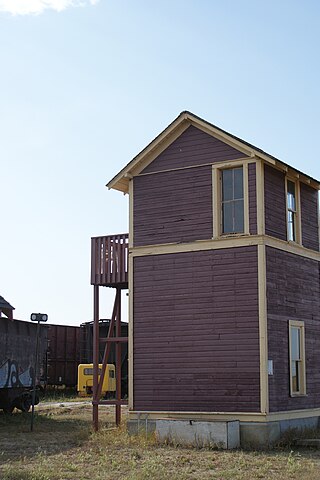
Oban is an unincorporated area administered by the rural municipality of Biggar No. 347, in the Canadian province of Saskatchewan. Oban is located on Saskatchewan Highway 14 in western Saskatchewan. The closest town is Biggar to the southeast. Biggar railway station is a divisional point for the Canadian National Railway (CNR). Oban had the last provincial interlocking tower at the Canadian National Railway and Canadian Pacific Railway level crossing, which was constructed in 1910 and closed in 1990.

Froude is an unincorporated community in the Canadian province of Saskatchewan, located in the Rural Municipality of Griffin No. 66, along the historic Ghost Town Trail, also known as the Red Coat Trail or Highway 13. The community is located approximately 42 km east of the city of Weyburn and 137 km southeast of the provincial capital city of Regina.


