The Chilcotin Group, also called the Chilcotin Plateau Basalts, is a large area of basaltic lava that forms a volcanic plateau running parallel with the Garibaldi Volcanic Belt in south-central British Columbia, Canada.
The Yilgarn Craton is a large craton that constitutes the bulk of the Western Australian land mass. It is bounded by a mixture of sedimentary basins and Proterozoic fold and thrust belts. Zircon grains in the Jack Hills, Narryer Terrane have been dated at ~4.27 Ga, with one detrital zircon dated as old as 4.4 Ga.

Volcanology of Canada includes lava flows, lava plateaus, lava domes, cinder cones, stratovolcanoes, shield volcanoes, submarine volcanoes, calderas, diatremes, and maars, along with examples of more less common volcanic forms such as tuyas and subglacial mounds. It has a very complex volcanological history spanning from the Precambrian eon at least 3.11 billion years ago when this part of the North American continent began to form.

A volcanic belt is a large volcanically active region. Other terms are used for smaller areas of activity, such as volcanic fields. Volcanic belts are found above zones of unusually high temperature (700-1400 °C) where magma is created by partial melting of solid material in the Earth's crust and upper mantle. These areas usually form along tectonic plate boundaries at depths of 10–50 km. For example, volcanoes in Mexico and western North America are mostly in volcanic belts, such as the Trans-Mexican Volcanic Belt that extends 900 km from west to east across central-southern Mexico and the Northern Cordilleran Volcanic Province in western Canada.
Sturgeon Lake Caldera is a large extinct caldera complex in Kenora District of Northwestern Ontario, Canada. It is one of the world's best preserved mineralized Neoarchean caldera complexes, containing well-preserved mafic-intermediate pillow lavas, pillow breccias, hyaloclastite and peperites, submarine lava domes and dome-associated breccia deposits. The complex is some 2.7 billion years old with a minimum strike length of 30 km (19 mi).
The Yellowknife greenstone belt, also called the Yellowknife Volcanic Belt, is an Archean greenstone belt in the southern Slave craton, Northwest Territories, Canada. It is mostly made of mafic volcanic rocks and is bordered to the east by batholithic intrusions of the Western Granodiorite Complex and beyond to the north by the Duckfish Lake Granite. Intrusive equivalents are collectively known as the Kam Group. Most of the Yellowknife townsite and the Con and Giant gold mines are within the Kam Group. The Yellowknife greenstone belt stands out as a positive topographic feature.
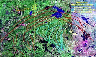
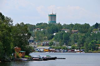
The Blake River Megacaldera Complex is a giant subaqueous caldera cluster or a nested caldera system that spans across the Ontario-Quebec border in Canada.
The Abitibi greenstone belt is a 2,800-to-2,600-million-year-old greenstone belt that spans across the Ontario–Quebec border in Canada. It is mostly made of volcanic rocks, but also includes ultramafic rocks, mafic intrusions, granitoid rocks, and early and middle Precambrian sediments.
The Uchi Subprovince is a Neoarchean volcanic sequence in Manitoba, Canada. It is at the southern margin of the North Caribou terrane and comprises a number of greenstone belts, which contains volcanic rocks that record some 280 million years of volcanism.

The Hope Bay greenstone belt, also called the Hope Bay volcanic belt, is a 42 km (26 mi) long Archean greenstone belt in western Nunavut, Canada. It consists of mostly mafic volcanic rocks and contains three major gold deposits called Boston, Doris and Naartok.
The Kam Group is a 10 km (6 mi) thick Archean volcanic group in the Yellowknife greenstone belt of the Northwest Territories, Canada. It consists of tholeiitic mafic and subordinate felsic volcanic rocks that were erupted in a submarine environment about 2706 million years ago.
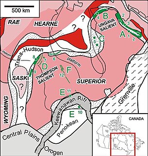
The Circum-Superior Belt is a widespread Paleoproterozoic large igneous province in the Canadian Shield of Northern, Western and Eastern Canada. It extends more than 3,400 km (2,100 mi) from northeastern Manitoba through northwestern Ontario, southern Nunavut to northern Quebec. Igneous rocks of the Circum-Superior Belt are mafic-ultramafic in composition, deposited in the Labrador Trough near Ungava Bay, the Cape Smith Belt near the southern shore of Hudson Strait and along the eastern shore of Hudson Bay in its northern portion; the Thompson and Fox River belts in the northwest and the Marquette Range Supergroup in its southern portion.

The volcanology of Eastern Canada includes the hundreds of volcanic areas and extensive lava formations in Eastern Canada. The region's different volcano and lava types originate from different tectonic settings and types of volcanic eruptions, ranging from passive lava eruptions to violent explosive eruptions. Eastern Canada has very large volumes of magmatic rock called large igneous provinces. They are represented by deep-level plumbing systems consisting of giant dike swarms, sill provinces and layered intrusions. The most capable large igneous provinces in Eastern Canada are Archean age greenstone belts containing a rare volcanic rock called komatiite.
Volcanology of Western Canada includes lava flows, lava plateaus, lava domes, cinder cones, stratovolcanoes, shield volcanoes, greenstone belts, submarine volcanoes, calderas, diatremes and maars, along with examples of more less common volcanic forms such as tuyas and subglacial mounds.

The volcanic history of the Northern Cordilleran Volcanic Province presents a record of volcanic activity in northwestern British Columbia, central Yukon and the U.S. state of easternmost Alaska. The volcanic activity lies in the northern part of the Western Cordillera of the Pacific Northwest region of North America. Extensional cracking of the North American Plate in this part of North America has existed for millions of years. Continuation of this continental rifting has fed scores of volcanoes throughout the Northern Cordilleran Volcanic Province over at least the past 20 million years and occasionally continued into geologically recent times.

The Algoman orogeny, known as the Kenoran orogeny in Canada, was an episode of mountain-building (orogeny) during the Late Archean Eon that involved repeated episodes of continental collisions, compressions and subductions. The Superior province and the Minnesota River Valley terrane collided about 2,700 to 2,500 million years ago. The collision folded the Earth's crust and produced enough heat and pressure to metamorphose the rock. Blocks were added to the Superior province along a 1,200 km (750 mi) boundary that stretches from present-day eastern South Dakota into the Lake Huron area. The Algoman orogeny brought the Archaen Eon to a close, about 2,500 million years ago; it lasted less than 100 million years and marks a major change in the development of the earth’s crust.

The Canadian Cascade Arc, also called the Canadian Cascades, is the Canadian segment of the North American Cascade Volcanic Arc. Located entirely within the Canadian province of British Columbia, it extends from the Cascade Mountains in the south to the Coast Mountains in the north. Specifically, the southern end of the Canadian Cascades begin at the Canada–United States border. However, the specific boundaries of the northern end are not precisely known and the geology in this part of the volcanic arc is poorly understood. It is widely accepted by geologists that the Canadian Cascade Arc extends through the Pacific Ranges of the Coast Mountains. However, others have expressed concern that the volcanic arc possibly extends further north into the Kitimat Ranges, another subdivision of the Coast Mountains, and even as far north as Haida Gwaii.

The Satah Mountain volcanic field (SMVF) is an extensive north-south trending volcanic chain in the Central Interior of British Columbia that stretches south of the Itcha Range shield volcano to northeast of Nimpo Lake. The chain is located on the Chilcotin Plateau, a major subdivision of the Interior Plateau that includes other nearby volcanic features. It forms a segment of the east-west trending Anahim Volcanic Belt, whose volcanic activity ranges in age from Miocene-to-Holocene. Volcanic features in the Satah Mountain field include lava domes, cinder cones and lava flows. Its name originates from Satah Mountain, the highest volcano, located 35 km (22 mi) northeast of Nimpo Lake.
The Iceland Lake Pluton, formerly known as the Ingall Lake Batholith, is a large granitic intrusion in Briggs and Strathcona townships of Temagami, Northeastern Ontario, Canada. It is one of the three separate granitoid intrusions that constitute the Temagami Greenstone Belt, consisting of rocks ranging from diorite to quartz monzonite. The age of the intrusion is estimated to be about 2,736 million years old, as well as an adjacent rhyolitic lava flow using the uranium–lead dating technique. This suggests that the Iceland Lake Pluton might be the remnants of a magma chamber of a volcano that erupted felsic magma. The pluton is overlain by sediments of the younger Huronian Supergroup.

The Tanzania Craton is an old and stable part of the continental lithosphere in central Tanzania. Some of the rocks are over 3 billion years old.