
The Canadian Shield, also called the Laurentian Plateau, is a large area of exposed Precambrian igneous and high-grade metamorphic rocks that forms the ancient geologic core of the North American continent. Glaciation has left the area with only a thin layer of soil, through which the composition of igneous rock resulting from long volcanic history is frequently visible. As a deep, common, joined bedrock region in eastern and central Canada, the Shield stretches north from the Great Lakes to the Arctic Ocean, covering over half of Canada and most of Greenland; it also extends south into the northern reaches of the United States. Human population is sparse and industrial development is minimal, but mining is prevalent.

Flin Flon is a mining city in Canada. It is located on a correction line on the Manitoba and Saskatchewan border, with the majority of the city located within Manitoba. Residents thus travel southwest into Saskatchewan, and northeast into Manitoba.
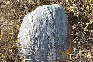
Greenstone belts are zones of variably metamorphosed mafic to ultramafic volcanic sequences with associated sedimentary rocks that occur within Archaean and Proterozoic cratons between granite and gneiss bodies.

Bakers Narrows, Manitoba, is a small residential community approximately 20 km (12 mi) southeast of Flin Flon on Lake Athapapuskow. There are five subdivisions located near the lakeshore with a total of approximately 150 cottages, many of which are permanent residences.
Hudbay Minerals Inc. is a diversified Canadian mining company primarily producing copper concentrate and zinc metal. Much of its history has centered on Flin Flon, Manitoba, where it has mined for over 90 years. Hudbay currently has operations in Manitoba and Peru, and is working towards building a copper mine in southern Arizona. The company also has exploration properties in Canada, Peru, Chile and the United States.
Flin Flon is a city on the Manitoba-Saskatchewan border in Canada.

The geography of Manitoba addresses the easternmost of the three prairie Canadian provinces, located in the longitudinal centre of Canada. Manitoba borders on Saskatchewan to the west, Ontario to the east, Nunavut to the north, and the American states of North Dakota and Minnesota to the south. Although the border with Saskatchewan appears straight on large-scale maps, it actually has many right-angle corners that give the appearance of a slanted line. In elevation, Manitoba ranges from sea level on Hudson Bay to 2727 ft (831 m) on top of Baldy Mountain. The northern sixty percent of the province is on the Canadian Shield. The northernmost regions of Manitoba lie permafrost, and a section of tundra bordering Hudson Bay.

Volcanic activity is a major part of the geology of Canada and is characterized by many types of volcanic landform, including lava flows, volcanic plateaus, lava domes, cinder cones, stratovolcanoes, shield volcanoes, submarine volcanoes, calderas, diatremes, and maars, along with less common volcanic forms such as tuyas and subglacial mounds.
The Bravo Lake Formation is a mafic volcanic belt and large igneous province located at the northern margin of the Trans-Hudson orogeny on central Baffin Island, Nunavut, Canada. It is exposed along a nearly continuous east–west passage for 120 km (75 mi) and changes in stratigraphic thickness from 1 to 2.5 kilometers. The formation is a rare alkaline-suite that formed as a result of submarine rifting during the Paleoproterozoic period. The Bravo Lake Formation is surprisingly undeformed by the Himalayan-scale forming event during the Trans-Hudsonian orogeny.

The Trans-Hudson orogeny or Trans-Hudsonian orogeny was the major mountain building event (orogeny) that formed the Precambrian Canadian Shield, the North American Craton, and the forging of the initial North American continent. It gave rise to the Trans-Hudson orogen (THO), or Trans-Hudson Orogen Transect (THOT), which is the largest Paleoproterozoic orogenic belt in the world. It consists of a network of belts that were formed by Proterozoic crustal accretion and the collision of pre-existing Archean continents. The event occurred 2.0-1.8 billion years ago.
The geology of Saskatchewan can be divided into two main geological regions, the Precambrian Canadian Shield and the Phanerozoic Western Canadian Sedimentary Basin. Within the Precambrian shield exists the Athabasca sedimentary basin. Meteorite impacts have altered the natural geological formation processes. The prairies were most recently affected by glacial events in the Quaternary period.

The Winnipegosis komatiite belt is a 150 km (93 mi) long and 30 km (19 mi) wide greenstone belt located in the Lake Winnipegosis area of central Manitoba, Canada. It has no surface exposure and was identified based on geophysical signatures and drilling during mineral exploration by Cominco during the 1990s. The belt has an age of 1870 ± 7 million years and is predominantly composed of basaltic and komatiitic volcanic rocks with minor intrusive and sedimentary rocks. The belt is considered part of the larger Circum-Superior Belt and was likely generated by a mantle plume. The Winnipegosis Komatiite Belt is notable as one of the few examples of komatiite formed during the Proterozoic.

The NorMan Junior Hockey League (NJHL) was Junior A hockey league in Northern Manitoba, Canada from 1978 until 1985. The NJHL was a member of the Manitoba Amateur Hockey Association, a part of the Canadian Amateur Hockey Association.

The Thompson King Miners were a junior ice hockey team from Thompson, Manitoba, Canada. The King Miners were members of the Manitoba Junior Hockey League and the NorMan Junior Hockey League.
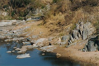
In central Manitoba lies the Flin Flon greenstone belt, which is one of the largest Paleoproterozoic volcanic-hosted massive sulphide districts in the world, containing 27 copper-zinc-(gold) deposits from which more than 183 million tonnes of sulphide have been mined.

The Hearne Craton is a craton in northern Canada which, together with the Rae Craton, forms the Western Churchill Province. Hearne is one of the six Archaean cratons of the Canadian Shield that are bound together by Palaeoproterozoic orogenic belts. Before being merged these six cratons formed independent microcontinents.
The geology of Sweden is the regional study of rocks, minerals, tectonics, natural resources and groundwater in the country. The oldest rocks in Sweden date to more than 2.5 billion years ago in the Precambrian. Complex orogeny mountain building events and other tectonic occurrences built up extensive metamorphic crystalline basement rock that often contains valuable metal deposits throughout much of the country. Metamorphism continued into the Paleozoic after the Snowball Earth glaciation as the continent Baltica collided with an island arc and then the continent Laurentia. Sedimentary rocks are most common in southern Sweden with thick sequences from the last 250 million years underlying Malmö and older marine sedimentary rocks forming the surface of Gotland.
The geology of Nunavut began to form nearly three billion years ago in the Archean and the territory preserves some of the world's oldest rock units.

