Questa is a village in Taos County, New Mexico, United States. The population was 1,770 at the 2010 census. The village has trails into the Rio Grande Gorge, trout fishing, and mountain lakes with trails that access the Sangre de Cristo Mountains that overlook the area. Questa is on the Enchanted Circle Scenic Byway, near the confluence of the Rio Grande and the Red River. The "Gateway to the Rio Grande del Norte Monument", its visitors can drive to an overlook of the Red River meeting the Rio Grande in the depth of the gorge. The Carson National Forest parallels Questa to the east. The Columbine Hondo Wilderness and Latir Peak Wildness are in the Carson National Forest close to Questa.

Red River is a resort town in Taos County, New Mexico, located in the Sangre de Cristo Mountains. The population was 477 at the 2010 census. Red River is located along the Enchanted Circle Scenic Byway, and is 36 miles (58 km) from Taos.

The Deschutes River in central Oregon is a major tributary of the Columbia River. The river provides much of the drainage on the eastern side of the Cascade Range in Oregon, gathering many of the tributaries that descend from the drier, eastern flank of the mountains. The Deschutes provided an important route to and from the Columbia for Native Americans for thousands of years, and then in the 19th century for pioneers on the Oregon Trail. The river flows mostly through rugged and arid country, and its valley provides a cultural heart for central Oregon. Today the river supplies water for irrigation and is popular in the summer for whitewater rafting and fishing.

The McCloud River is a 77.1-mile (124.1 km) long river that flows east of and parallel to the upper Sacramento River, in Siskiyou County and Shasta County in northern California in the United States. Protected under California's Wild and Scenic Rivers Act (1972), it drains a scenic mountainous area of the Cascade Range, including part of Mount Shasta. It is a tributary of the Pit River, which in turn flows into the Sacramento River. The three rivers join in Shasta Lake, formed by Shasta Dam north of Redding.

The Rio Grande Gorge is a geological feature in northern New Mexico where the watercourse of the Rio Grande follows a tectonic chasm. Beginning near the Colorado border, the approximately 50-mile (80 km) gorge runs from northwest to southwest of Taos, New Mexico, through the basalt flows of the Taos Plateau volcanic field. The gorge depth is 800 feet (240 m) just south of the Rio Grande Gorge Bridge, which spans the gorge 10 miles (16 km) northwest of Taos.

The Santa Ynez River is one of the largest rivers on the Central Coast of California. It is 92 miles (148 km) long, flowing from east to west through the Santa Ynez Valley, reaching the Pacific Ocean at Surf, near Vandenberg Space Force Base and the city of Lompoc.

Amistad Reservoir is a reservoir on the Rio Grande at its confluence with the Devils River 12 miles (19 km) northwest of Del Rio, Texas. The lake is bounded by Val Verde County on the United States side of the international border and by the state of Coahuila on the Mexican side of the border; the American shoreline forms the Amistad National Recreation Area. The reservoir was formed in 1969 by the construction of Amistad Dam. The dam and lake are managed jointly by the governments of the United States and Mexico through the International Boundary and Water Commission. The name of the dam and lake is the Spanish word for "friendship". The reservoir is also known as Lake Amistad.

The Metolius River is a tributary of the Deschutes River in Central Oregon, United States, near the city of Sisters. The river flows north from springs near Black Butte, then turns sharply east, descending through a series of gorges before ending in the western end of the lake. The unincorporated community of Camp Sherman lies astride the southern end of the river. The name of the river comes from the Warm Springs or Sahaptin word mitula, meaning white salmon and referring to a light colored Chinook salmon and not a whitefish.

Carson National Forest is a national forest in northern New Mexico, United States. It encompasses 6,070 square kilometers and is administered by the United States Forest Service. The Forest Service's "mixed use" policy allows for its use for recreation, grazing, and resource extraction.

The Rio Chama, a major tributary river of the Rio Grande, is located in the U.S. states of Colorado and New Mexico. The river is about 130 miles (210 km) long altogether. From its source to El Vado Dam its length is about 50 miles (80 km), from El Vado Dam to Abiquiu Dam is about 51 miles (82 km), and from Abiquiu Dam to its confluence with the Rio Grande is about 34 miles (55 km).

The Cimarron River, flowing entirely in New Mexico, was also known as La Flecha or Semarone. Its headwaters are Moreno, Sixmile, and Cieneguilla creeks in the Sangre de Cristo Mountains, which feed into Eagle Nest Dam. From the dam, it runs for 60 miles (97 km) to below the city of Springer, New Mexico in the Taylor Springs area, where it flows into the Canadian River, the southwesternmost major tributary flowing into the Mississippi River via the Arkansas River sub-basin.
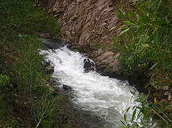
The Rio Hondo is a river in northern New Mexico. A left tributary of the Rio Grande, it flows approximately 20 miles (32 km) from its headwaters high in the Sangre de Cristo Mountains near Wheeler Peak and the Taos Ski Valley to its discharge in the Rio Grande Gorge just west of the community of Arroyo Hondo. Portions of the Rio Hondo are prized as prime spots for bird-watching and fishing. The river was the subject of a 2005 study by the New Mexico Environment Department Surface Water Quality Bureau into the effects of wastewater from Taos Ski Valley, which is discharged from the Village of Taos Ski Valley Waste Water Treatment Plant.

Scofield Reservoir is a 2,815-acre (11.39 km2) reservoir impounded by Scofield Dam, in Carbon County, Utah. Located on the Price River, a tributary of the Green River, Scofield Reservoir is adjacent to the northernmost boundary of the Manti–La Sal National Forest. The reservoir sits at an elevation of 7,618 feet (2,322 m), on the northern edge of the Wasatch Plateau. Utah State Route 96 runs along the western shoreline.
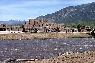
The Rio Pueblo de Taos, also known as Rio Pueblo, is a stream in Taos County, New Mexico, United States, that a tributary of the Rio Grande. From its source in the Sangre de Cristo Mountains it flows about 33 miles (53 km), generally south and west, to join the Rio Grande in the Rio Grande Gorge. On the way the river passes by Taos and through Taos Pueblo.

Rio Culebra is a river or creek in Costilla County, Colorado. The Rio Culebra rises in the Sangre de Cristo Mountains and is 48 km (30 mi) long. It empties into the Rio Grande west of the town of San Luis. The region around San Luis features extensive agriculture made possible by irrigation water from the river. Sometimes called the "Culebra Basin" this area is known for the extensive irrigation canals called acequias built by its Hispanic settlers in the 19th century and still in use in the 21st century
The Rio Brazos is a 42-mile (68 km) long river flowing through northern New Mexico in the United States. It rises in the Tusas Mountains, a subrange of the San Juan Mountains, and runs generally southwest to a confluence with the Rio Chama, part of the larger Rio Grande system.

The Rio Grande del Norte National Monument is an approximately 242,555-acre (98,159 ha) area of public lands in Taos County, New Mexico, proclaimed as a national monument on March 25, 2013, by President Barack Obama under the provisions of the Antiquities Act. It consists of the Rio Grande Gorge and surrounding lands, managed by the Bureau of Land Management (BLM).

The Enchanted Circle Scenic Byway is a New Mexico Scenic Byway and National Forest Scenic Byway located in Northern New Mexico. It begins and ends in Taos, New Mexico.

Wild Rivers Recreation Area is located in north central New Mexico within the Rio Grande del Norte National Monument. Two rivers that run through the park, the Rio Grande and Red River are National Wild and Scenic Rivers. NM 378 that traverses the recreation area is designated a New Mexico Scenic Byway. Recreational opportunities include whitewater rafting, hiking, biking, fishing and camping.

Costilla Creek is a tributary of the Rio Grande in Colorado and New Mexico.