
The Woodland Trust is the largest woodland conservation charity in the United Kingdom and is concerned with the creation, protection, and restoration of native woodland heritage. It has planted over 50 million trees since 1972.
The Lancashire Wildlife Trust or Wildlife Trust for Lancashire, Manchester and North Merseyside is a wildlife trust covering the county of Lancashire and parts of Greater Manchester and Merseyside in England.

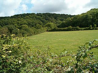
Long Dole Wood and Meadows SSSI is a 9.8 hectares biological Site of Special Scientific Interest (SSSI) between the villages of Farrington Gurney and Hinton Blewitt in Bath and North East Somerset, notified in 1987.
Aller and Beer Woods is a 56.9 hectares biological Site of Special Scientific Interest. off the A372 Othery to Langport road near Aller in Somerset. It was notified in 1952.

Red Moss is a wetland mossland in Greater Manchester, located south of Horwich and east of Blackrod. This is a national Site of Special Scientific Interest in the United Kingdom, due to its biodiversity and undisturbed character. Pollen analysis has revealed the first peat deposits of the northwest's mosslands to be from around 8,000 years BC making Red Moss an impressive 10,000 years old. Red Moss covers an area of 47.2 hectares. A severed female head was discovered in Red Moss in the 19th century dating from the Bronze Age or early Iron Age.

Grass Wood is an ancient woodland of 88 hectares in Wharfedale, North Yorkshire, England, that has an exceptional ground flora of woodland wildflowers.

Backstone Bank and Baal Hill Woods is a Site of Special Scientific Interest in the County Durham district of Durham, England. It occupies the steep eastern slopes of the valley of Waskerley Beck, alongside and downstream of Tunstall Reservoir, some 3 km north of Wolsingham and is one of the largest expanses of semi-natural woodland in west Durham.
Cotterill Clough is a 5.6-hectare (14-acre) nature reserve near Manchester Airport. It is managed by the Cheshire Wildlife Trust and lies within a larger Site of Special Scientific Interest (SSSI). The Cotterill Brook, which flows through the reserve, is a tributary of the River Bollin. The reserve was purchased in 1934 by public subscription as a memorial to T. A. Coward (1867–1933), a famous Cheshire naturalist. It is 15 kilometres south of Manchester city centre and adjacent to Manchester Airport.

Brockholes is a nature reserve near Preston, Lancashire, England, just off Junction 31 of the M6 motorway. It is owned by the Wildlife Trust for Lancashire, Manchester and North Merseyside. Situated in the flood-plain of the river Ribble, it has the UK's first floating visitor village.

Upper Wye Gorge is a Site of Special Scientific Interest (SSSI), noted for its biological and geological characteristics, around Symonds Yat in the Wye Valley on the Wales–England border. The site is listed in the "Forest of Dean Local Plan Review" as a Key Wildlife Site (KWS).
Briarwood Banks is the name given to a woodland Site of Special Scientific Interest (SSSI) in north Northumberland, North East England. Composed mainly of elm, oak and ash, the site is semi-natural and now recovering from the removal of planted conifers.

Quarry Moor is a Site of Special Scientific Interest, or SSSI, at the south edge of Ripon, North Yorkshire, England, and adjacent to the A61 road. It contains an outcrop of Magnesian Limestone, exposed by former quarrying. 255 million years ago this limestone was the peripheral sediment of a tropical sea. The land was donated in 1945 to the people of Ripon by the town's mayor, Alderman Thomas Fowler Spence, a varnish manufacturer. The land was notified as an SSSI in 1986 because its calcareous grassland supported a large diversity of plant species. The site features a Schedule 8 protected plant, thistle broomrape. The land is protected as a nature reserve, and it is also managed as a recreational area. Therefore, its calcareous grass area is fenced off for protection and study, but it also contains a car park, information signs, a children's play area, accessible paths, benches, and dog waste bins.

Hack Fall Wood, otherwise known as Hackfall, is a Site of Special Scientific Interest, or SSSI, of 44.8687 hectares, lying north-east of the village of Grewelthorpe, North Yorkshire, England. During the 18th century it was landscaped in the picturesque style by landowner William Aislabie, who created views by engineering streams and pools, planting trees and building follies. J. M. W. Turner and William Sawrey Gilpin painted it, and pictures of it featured on Catherine the Great's 1773 Wedgwood dinner service. Some 19th century writers called it "one of the most beautiful woods in the country."

Mere Sands Wood is a 105 acres (42 ha) nature reserve between the villages of Holmeswood and Rufford in west Lancashire, England, managed by The Wildlife Trust for Lancashire, Manchester & North Merseyside. It lies about five miles from Ormskirk. The name derives from when the area was on the shore of Martin Mere.
Holystone Burn Woods is a Site of Special Scientific Interest (SSSI) within Northumberland National Park in Northumberland, England. It is located near the village of Holystone. The protected area includes part of the valley along which flows the stream called Holystone Burn. Part of the protected area is managed by the Northumberland Wildlife Trust.
Stawardpeel Woods is a Site of Special Scientific Interest (SSSI) in Northumberland, England. This protected area is located in the valley of the River Allen, near Bardon Mill. The protected area is owned by the National Trust, within the Allen Banks & Staward Gorge estate.
Holystone North Wood is a Site of Special Scientific Interest (SSSI) in Northumberland National Park, Northumberland, England. It is located near the village of Holystone. The woodland was historically an oak coppice.
Irthing Gorge is a Site of Special Scientific Interest on the border between the counties of Northumberland and Cumbria, in England. It is located on the south-western boundary of Northumberland National Park where the River Irthing flows near the village of Gilsland. This protected has an exceptional mixture of habitats, including hillside woodland, seepage areas and bare rock. The gorge here cuts through moorland.
