Regio I Porta Capena

Last updated
RegioIRome.png

The Regio I Porta Capena is the first regio of imperial Rome, under Augustus's administrative reform. Regio I took its name from the Porta Capena ("Gate to Capua"), a gate of the Servian Walls, through which the Appian Way entered the city prior to the construction of the Aurelian Walls.

Contents

Geographic extent and important features

Bordered to the north by the Via Appia as it passed between the Palatine Hill and the Caelian Hill, Regio I stretched through the ancient Porta Capena either to at least the boundary of the future Aurelian Walls, and possibly originally beyond the Porta Appia. [1] Including areas that were traversed by the Via Appia and the Via Latina, the boundary eventually turned back towards the ancient city until it returned back to the Caelian Hill. Prior to the construction of the Aurelian Walls, it is unclear how far along the Via Appia Regio I continued. [2] A measurement taken at the end of the 4th century recorded that the perimeter of the region was 12,219 Roman feet (approximately 3.61 km). [3]

The so-called Arch of Drusus Drususbogen.jpg
The so-called Arch of Drusus

Within this region lay a spring and a grove once sacred to the nymph Egeria, a divine consort and counsellor of Numa Pompilius, the second king of Rome. A brook called the Almo was nearby; this was where annually, on 27 March, the sacred black stone of the Magna Mater was brought from her temple on the Palatine Hill to where the brook crossed the Via Appia south of the Porta Capena, for the ceremony of lavatio (washing). Also present was the oldest temple to Mars in Rome, "Templum Martis in Clivo". Built near the first miliarium of the Via Appia, it was where, in Republican times, the legions gathered prior to their allotted campaign, and where they returned to lay down their arms before re-entering the city. [4] Along with the Temple of Mars, this region also had a temple dedicated to Minerva and one to the Tempestas.

Between the Servian and Aurelian Walls stood three Triumphal arches that spanned the via Appia: the Arch of Drusus, the Arch of Lucius Verus and Marcus Aurelius (for the Parthian triumph of 166 CE) and the Arch of Trajan. Neither of the first two arches are extant; however, the so-called Arch of Drusus that is still standing in the former Regio I is most likely the remains of the Arch of Trajan. [5]

Regio I also included the Baths of Commodus and the Septizodium . Finally, it also contained the Mutatorium Caesaris. This was an area reserved for the Imperial family where their private transport could be housed and held for use whenever they returned to the capital from the Via Appia. At the turn of the 5th century, the Regio contained ten aediculae (shrines), 120 domūs (patrician houses), 26 horrea (warehouses), 86 balneae (bath houses) and 87 loci (fountains). [6]

If the region extended beyond the Aurelian Wall, the region will also have included the Circus of Maxentius and the Tomb of Caecilia Metella. [7]

Subdivisions

At the turn of the 5th century, the Regio was divided into ten vici (districts) and 3,250 insulae (blocks). It had two curators and was served by 48 Roman magistrates. [8]

See also

Notes

  1. Gregorovius, pg. 29
  2. Gregorovius, pg. 31
  3. Notitia, REGIO I PORTA CAPENA
  4. "Templum Martis in Clivo".
  5. Richardson, L. A New Topographical Dictionary of Ancient Rome (1992), pgs. 30-31
  6. Notitia, REGIO I PORTA CAPENA
  7. Gregorovius, pg. 30
  8. Notitia, REGIO I PORTA CAPENA

Related Research Articles

<span class="mw-page-title-main">Porta Capena</span>

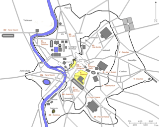
The Porta Capena was a gate in the Servian Wall in Rome, Italy. The gate was located in the area of Piazza di Porta Capena, where the Caelian, Palatine and Aventine hills meet. Probably its exact position was between the entrance of Via di Valle delle Camene and the beginning of Via delle Terme di Caracalla, facing the curved side of the Circus Maximus.

The Caelian Hill is one of the famous seven hills of Rome.

<span class="mw-page-title-main">Servian Wall</span> Defensive barrier around the ancient city of Rome

The Servian Wall is an ancient Roman defensive barrier constructed around the city of Rome in the early 4th century BC. The wall was built of volcanic tuff and was up to 10 m (33 ft) in height in places, 3.6 m (12 ft) wide at its base, 11 km (6.8 mi) long, and is believed to have had 16 main gates, of which only one or two have survived, and enclosed a total area of 246 hectares. In the 3rd century AD it was superseded by the construction of the larger Aurelian Walls as the city of Rome grew beyond the boundary of the Servian Wall.

<span class="mw-page-title-main">14 regions of Augustan Rome</span> Administrative subdivisions of ancient Rome

In 7 BC, Augustus divided the city of Rome into 14 administrative regions. These replaced the four regiones—or "quarters"—traditionally attributed to Servius Tullius, sixth king of Rome. They were further divided into official neighborhoods.

Porta can refer to:

<span class="mw-page-title-main">Regio II Caelimontium</span> Historical region of Rome

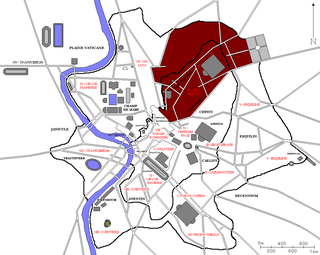
The Regio II Caelimontium is the second regio of imperial Rome, under Augustus's administrative reform. It took its name from the Caelian Hill, which the region was centred on.

The Temple of Mars in Clivo was a temple on the western side of the Via Appia in Rome, between the first and second milestones, built in the early 4th century BCE, and dedicated to Mars. It was the oldest standing temple dedicated to Mars within the city.

<span class="mw-page-title-main">Regio III Isis et Serapis</span> Historical region of Rome

The Regio III Isis et Serapis was the third regio of imperial Rome, under Augustus's administrative reform. Regio III took its name from the double sanctuary of Isis and Serapis, in the area of the Via Praenestina, containing the valley that was to be the future site of the Colosseum, and parts of the Oppian and Esquiline hills.

<span class="mw-page-title-main">Regio IV Templum Pacis</span> Historical region of Rome

The Regio IV Templum Pacis is the fourth regio of imperial Rome, under Augustus's administrative reform. Regio IV took its name from the Temple of Peace built in the region by the emperor Vespasian. It includes the valley between the Esquiline and the Viminal hills, the popular area of the Suburra, and the Velian Hill.

<span class="mw-page-title-main">Regio V Esquiliae</span> Historical region of Rome

The Regio V Esquiliae is the fifth regio of imperial Rome, under Augustus's administrative reform. Regio V took its name from the Esquiline Hill. It contains parts of the Oppian Hill and Cispian Hill and of the Esquiline, plus the plain just outside the Servian Wall.

<span class="mw-page-title-main">Regio VI Alta Semita</span> Historical region of Rome

The Regio VI Alta Semita is the sixth regio of imperial Rome, under Augustus's administrative reform. Regio VI took its name from the street passing over the Quirinal Hill. It was a large regio that also encompassed the Viminal Hill, the lower slopes of the Pincian, and the valleys in-between.

<span class="mw-page-title-main">Regio VII Via Lata</span> Historical region of Rome

The Regio VII Via Lata is the seventh regio of imperial Rome, under Augustus's administrative reform. Regio VII took its name from the wide urban street the Via Lata. It was the urban section of the Via Flaminia, which ran between the Servian walls and the Aurelian Walls, and corresponds to the modern Via del Corso. The regio contained part of the Campus Martius on the east of the street plus the Collis Hortulorum, the Pincian Hill.

<span class="mw-page-title-main">Regio VIII Forum Romanum</span> Historical region of Rome

The Regio VIII Forum Romanum Magnum is the eighth regio of imperial Rome, under Augustus's administrative reform. Regio VIII took its name from the Roman Forum, the political centre of Ancient Rome.

<span class="mw-page-title-main">Regio IX Circus Flaminius</span> Historical region of Rome

The Regio IX Circus Flaminius is the ninth regio of imperial Rome, under Augustus's administrative reform. Regio IX took its name from the racecourse located in the southern end of the Campus Martius, close to Tiber Island.

<span class="mw-page-title-main">Regio X Palatium</span> Historical region of Rome

The Regio X Palatium is the tenth regio of imperial Rome, under Augustus's administrative reform. Regio X took its name from the Palatine Hill and the imperial palaces located on it.

<span class="mw-page-title-main">Regio XI Circus Maximus</span> Historical region of Rome

The Regio XI Circus Maximus is the eleventh regio of imperial Rome, under Augustus's administrative reform. Regio XI took its name from the Circus Maximus, located in the valley between the Palatine and the Aventine hills.

<span class="mw-page-title-main">Regio XII Piscina Publica</span> Historical region of Rome

The Regio XII Piscina Publica is the twelfth regio of imperial Rome, under Augustus's administrative reform. Regio XII took its name from the Piscina Publica, a swimming pool that disappeared during the middle imperial period.

<span class="mw-page-title-main">Regio XIII Aventinus</span> Historical region of Rome

The Regio XIII Aventinus is the thirteenth regio of imperial Rome, under Augustus's administrative reform. Regio XIII took its name from the hill which dominated the region, the Aventine.

<span class="mw-page-title-main">Regio XIV Transtiberim</span> Historical region of Rome

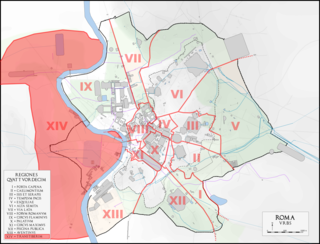
The Regio XIV Transtiberim is the fourteenth regio of imperial Rome, under Augustus's administrative reform. Meaning "across the Tiber", the Regio took its name from its position on the west bank of the Tiber River.

References