
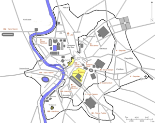
The Regio XIV Transtiberim is the fourteenth regio of imperial Rome, under Augustus's administrative reform. Meaning "across the Tiber", the Regio took its name from its position on the west bank of the Tiber River.
The Regio XIV Transtiberim is the fourteenth regio of imperial Rome, under Augustus's administrative reform. Meaning "across the Tiber", the Regio took its name from its position on the west bank of the Tiber River.
Regio XIV comprised the land around the two hills on the west side of the Tiber, the Vatican Hill to the north (including the Ager Vaticanus) and the Janiculum Hill to the south, as well as the Tiber Island. [1] While the area around the Janiculum was eventually encased with the Aurelian Walls, the area around the Vatican did not possess any walls until the ninth century. [2] The principal roads that exited and entered the region were the Via Cornelia, the Via Aurelia (through the Porta Aurelia) and the Via Portuensis (through the Porta Portuensis). The final gate in the Aurelian Walls in this region was the Porta Settimiana. A measurement taken at the end of the 4th century recorded that the perimeter of the region was 33,388 Roman feet (approximately 9.9 km), making it the largest of the Augustan regions. [3]

This region was largely devoted to entertaining the Roman people, so it was dotted with many extensive gardens and parks. It was also popular with the emperors, and they would frequently reside in their imperial villas in this part of Rome when not performing their official duties. [4] Such imperial gardens included the Horti Agrippinae , the Gardens of Nero and the Horti Domitiae . In the north of the region was an entertainment complex which included the Circus of Gaius (for many years mistakenly called the Circus of Nero) and the Naumachia Traiani , where mock naval battles were held. By the middle of the 4th century, the Circus of Nero had largely been built over by the Basilica of Saint Peter, built on the orders of Constantine I. Close by is the Mausoleum of Hadrian. [5]

In the area below the Janiculum stood the Naumachia of Augustus, one of the five naumachiae in Regio XIV. It was in the area around the Janiculum where most of the population in Transtiberim lived. [6] Around the Porta Settimiana stood the Gardens of Geta, laid out by his father. Further along stood the nemus Cæsarum (or sacred forest of the Caesars), while at the southernmost extremity of the region stood the Horti Caesaris gardens, which included a villa belonging to Julius Caesar where Cleopatra stayed during her visit to Rome. Regio XIV also contained several religious sites, including a shrine to Cybele and one to Furrina, as well as a temple to Fors Fortuna .
On the Tiber Island stood the Temple of Asclepius. In addition, it contained several shrines: [7]
Among the more obscure features mentioned in the 5th century Notitia in this region was a prominent statue to an unknown member of the gens Valeria , and the “Sleeping Hercules”, a buried statue of the god. The region also contained the station of the seventh cohort of the Vigiles . At the turn of the 5th century, the Regio contained 78 aediculae (shrines), 150 domūs (patrician houses), 22 horrea (warehouses), 86 balneae (bath houses) and 180 loci (fountains). [8]
As Regio XIV was situated across the Tiber, passage to and from this region to the rest of Rome was by bridge, of which there were eight: [9]
At the turn of the 5th century, the Regio was divided into 78 vici (districts) and 4,405 insulae (blocks). It had two curators and was served by 48 Roman magistrates. [10]

Trastevere is the 13th rione of Rome, Italy. It is identified by the initials R. XIII and it is located within Municipio I. Its name comes from Latin trans Tiberim.

A rione of Rome is a traditional administrative division of the city of Rome. Rione is an Italian term used since the 14th century to name a district of a town. The term was born in Rome, originating from the administrative divisions of the city. The word comes from the Latin word regio, meaning "region"; during the Middle Ages the Latin word became rejones, from which rione comes. Currently, all the rioni are located in Municipio I of Rome.
In 7 BC, Augustus divided the city of Rome into 14 administrative regions. These replaced the four regiones—or "quarters"—traditionally attributed to Servius Tullius, sixth king of Rome. They were further divided into official neighborhoods.
Porta San Pancrazio is one of the southern gates of the Aurelian walls in Rome, Italy.

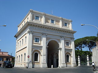
Porta Settimiana is one of the gates of the Aurelian walls in Rome, Italy. It rises at the northern vertex of the rough triangle traced by the town walls, built by Emperor Aurelian in the 3rd century, in the area of Trastevere an up through the Janiculum.

The Regio I Porta Capena is the first regio of imperial Rome, under Augustus's administrative reform. Regio I took its name from the Porta Capena, a gate of the Servian Walls, through which the Appian Way entered the city prior to the construction of the Aurelian Walls.

The Regio II Caelimontium is the second regio of imperial Rome, under Augustus's administrative reform. It took its name from the Caelian Hill, which the region was centred on.

In ancient Rome, the Ager Vaticanus was the alluvial plain on the right (west) bank of the Tiber. It was also called Ripa Veientana or Ripa Etrusca, indicating the Etruscan dominion during the archaic period. It was located between the Janiculum, the Vatican Hill, and Monte Mario, down to the Aventine Hill and up to the confluence of the Cremera creek.

The Regio III Isis et Serapis was the third regio of imperial Rome, under Augustus's administrative reform. Regio III took its name from the double sanctuary of Isis and Serapis, in the area of the Via Praenestina, containing the valley that was to be the future site of the Colosseum, and parts of the Oppian and Esquiline hills.

The Regio IV Templum Pacis is the fourth regio of imperial Rome, under Augustus's administrative reform. Regio IV took its name from the Temple of Peace built in the region by the emperor Vespasian. It includes the valley between the Esquiline and the Viminal hills, the popular area of the Suburra, and the Velian Hill.

The Regio V Esquiliae is the fifth regio of imperial Rome, under Augustus's administrative reform. Regio V took its name from the Esquiline Hill. It contains parts of the Oppian Hill and Cispian Hill and of the Esquiline, plus the plain just outside the Servian Wall.
The Regio VI Alta Semita is the sixth regio of imperial Rome, under Augustus's administrative reform. Regio VI took its name from the street passing over the Quirinal Hill. It was a large regio that also encompassed the Viminal Hill, the lower slopes of the Pincian, and the valleys in-between.

The Regio VII Via Lata is the seventh regio of imperial Rome, under Augustus's administrative reform. Regio VII took its name from the wide urban street the Via Lata. It was the urban section of the Via Flaminia, which ran between the Servian walls and the Aurelian Walls, and corresponds to the modern Via del Corso. The regio contained part of the Campus Martius on the east of the street plus the Collis Hortulorum, the Pincian Hill.

The Regio VIII Forum Romanum Magnum is the eighth regio of imperial Rome, under Augustus's administrative reform. Regio VIII took its name from the Roman Forum, the political centre of Ancient Rome.

The Regio IX Circus Flaminius is the ninth regio of imperial Rome, under Augustus's administrative reform. Regio IX took its name from the racecourse located in the southern end of the Campus Martius, close to Tiber Island.

The Regio X Palatium is the tenth regio of imperial Rome, under Augustus's administrative reform. Regio X took its name from the Palatine Hill and the imperial palaces located on it.

The Regio XI Circus Maximus is the eleventh regio of imperial Rome, under Augustus's administrative reform. Regio XI took its name from the Circus Maximus, located in the valley between the Palatine and the Aventine hills.

The Regio XII Piscina Publica is the twelfth regio of imperial Rome, under Augustus's administrative reform. Regio XII took its name from the Piscina Publica, a swimming pool that disappeared during the middle imperial period.

The Regio XIII Aventinus is the thirteenth regio of imperial Rome, under Augustus's administrative reform. Regio XIII took its name from the hill which dominated the region, the Aventine.