You can help expand this article with text translated from the corresponding article in Italian. (November 2024)Click [show] for important translation instructions.
Machine translation, like DeepL or Google Translate, is a useful starting point for translations, but translators must revise errors as necessary and confirm that the translation is accurate, rather than simply copy-pasting machine-translated text into the English Wikipedia.
Consider adding a topic to this template: there are already 730 articles in the main category, and specifying|topic= will aid in categorization.
Do not translate text that appears unreliable or low-quality. If possible, verify the text with references provided in the foreign-language article.
You must provide copyright attribution in the edit summary accompanying your translation by providing an interlanguage link to the source of your translation. A model attribution edit summary is Content in this edit is translated from the existing Italian Wikipedia article at [[:it:Via Portuense]]; see its history for attribution.
You may also add the template {{Translated|it|Via Portuense}} to the talk page.
The Via Portuensis was an ancient Roman road, leading to the Portus constructed by Claudius on the right bank of the Tiber, at its mouth. It started from the Pons Aemilius, and the first part of its course is identical with that of the Via Campana. The Porta Portuensis of the Aurelian Walls had a double arch, probably owing to the amount of traffic it had to carry, but the divergence occurred a good deal further on, probably a mile from the gate. The Via Portuensis went to the right into hilly country, while the Via Campana kept to the valley of the Tiber. The roads rejoined at the modern Ponte Galeria.
With the growth of importance of the Via Portuensis from the time of Constantine onwards, that of the Via Ostiensis correspondingly decreased. Procopius, who describes how barges were dragged up the river by teams of oxen moving along it, must be describing the towpath, and not either the Via Portuensis or even the Via Campana, which is in many places at quite a considerable distance from the winding course of the river.
Its large amounts of traffic caused the road to be eventually reconstructed with two parallel roads: one for traffic going one way and the other for traffic going the other. It is considered to have been the world's first dual carriageway.
Today Rome's Via Portuense follows a similar path. The road starts today from the Porta Portese and, after Ponte Galeria, ends in the comune of Fiumicino.
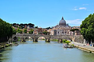
The Tiber is the third-longest river in Italy and the longest in Central Italy, rising in the Apennine Mountains in Emilia-Romagna and flowing 406 km (252 mi) through Tuscany, Umbria, and Lazio, where it is joined by the River Aniene, to the Tyrrhenian Sea, between Ostia and Fiumicino. It drains a basin estimated at 17,375 km2 (6,709 sq mi). The river has achieved lasting fame as the main watercourse of the city of Rome, which was founded on its eastern banks.
The Via Flaminia was an ancient Roman road leading from Rome over the Apennine Mountains to Ariminum (Rimini) on the coast of the Adriatic Sea, and due to the ruggedness of the mountains was the major option the Romans had for travel between Etruria, Latium, Campania, and the Po Valley. The section running through northern Rome is where Constantine the Great, allegedly, had his famous vision of the Chi Rho, leading to his conversion to Christianity and the Christianization of the Roman Empire.
The Via Clodia was an ancient high road of Italy. Situated between the Via Cassia and the Via Aurelia, it is different from them notably in that the latter was designed primarily for military long-haul, irrespective of settlements they met, but the Via Clodia was of short-range, intended for commercial traffic with the colonies in Etruscan lands.
The Pons Sublicius is the earliest known bridge of ancient Rome, spanning the Tiber River near the Forum Boarium downstream from the Tiber Island, near the foot of the Aventine Hill. According to tradition, its construction was ordered by Ancus Marcius around 642 BC, but this date is approximate because there is no ancient record of its construction. Marcius wished to connect the newly fortified Janiculum Hill on the Etruscan side to the rest of Rome, augmenting the ferry that was there. The bridge was part of public works projects that included building a port at Ostia, at the time the location of worked salt deposits.
Borgo is the 14th rione of Rome, Italy. It is identified by the initials R. XIV and is included within Municipio I.
Campo Marzio is the 4th rione of Rome, Italy, identified by the initials R. IV. It belongs to the Municipio I and covers a smaller section of the area of the ancient Campus Martius. The logo of this rione is a silver crescent on a blue background.
Portus was a large artificial harbour of Ancient Rome located at the mouth of the Tiber on the Tyrrhenian Sea. It was established by Claudius and enlarged by Trajan to supplement the nearby port of Ostia.
The Via Ostiensis was an important road in ancient Rome. It ran west 30 kilometres (19 mi) from the city of Rome to its important sea port of Ostia Antica, from which it took its name. The road began near the Forum Boarium, ran between the Aventine Hill and the Tiber River along its left (eastern) bank, and left the city's Servian Walls through the Porta Trigemina. When the later Aurelian Walls were built, the road left the city through the Porta Ostiensis. In the Late Roman Empire, trade suffered under an economic crisis, and Ostia declined as an important port. With the accompanying growth of importance of the Via Portuensis from the time of Constantine onwards, that of the Via Ostiensis correspondingly decreased.
The Via Giulia is a street of historical and architectural importance in Rome, Italy, which runs along the left (east) bank of the Tiber from Piazza San Vincenzo Pallotti, near Ponte Sisto, to Piazza dell'Oro. It is about 1 kilometre long and connects the Regola and Ponte Rioni.
Porta Portese is an ancient city gate, located at the end of Via Portuense, where it meets Via Porta Portese, about a block from the banks of the Tiber in the southern edge of the Rione Trastevere of Rome, Italy.
Ponte Galeria is the 41st zona of Rome, Italy, identified by the initials Z. XLI. Geographically it was part of Agro Romano. The zone belongs to the Municipio XI.
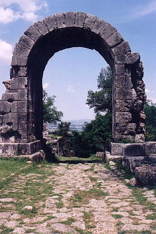
Porta Settimiana is one of the gates of the Aurelian walls in Rome, Italy. It rises at the northern vertex of the rough triangle traced by the town walls, built by Emperor Aurelian in the 3rd century, in the area of Trastevere and up through the Janiculum.
Ponte Sublicio, also known as Ponte Aventino or Ponte Marmoreo, is a bridge linking Piazza dell'Emporio to Piazza di Porta Portese in Rome (Italy), in the Rioni Ripa, Trastevere and Testaccio and in the Quartiere Portuense.
The Pons Probi was a bridge over the River Tiber in Ancient Rome, just south of Porta Trigemina.
The Janiculum walls are a stretch of defensive walls erected in 1643 by Pope Urban VIII as a completion of the Leonine wall and for a better protection of the area of Rome rising on the right bank of the Tiber.
Ponte della Magliana is a motorway bridge in Rome (Italy). It crosses the Tiber between Pian due Torri and Via del Cappellaccio, linking the Quartieri Portuense and Ostiense, respectively, on the right and on the left of the river.
The Rome–Fiumicino railway is an urban railway line in Rome.
In ancient Rome, the Ager Vaticanus was the alluvial plain on the right (west) bank of the Tiber. It was also called Ripa Veientana or Ripa Etrusca, indicating the Etruscan dominion during the archaic period. It was located between the Janiculum, the Vatican Hill, and Monte Mario, down to the Aventine Hill and up to the confluence of the Cremera creek.
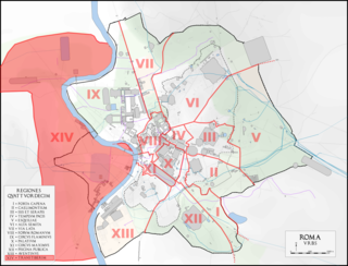
The Regio XIV Transtiberim is the fourteenth regio of imperial Rome, under Augustus's administrative reform. Meaning "across the Tiber", the Regio took its name from its position on the west bank of the Tiber River.
The via Tiberina was an ancient Roman road, which from the north of Rome, going up the right bank of the Tiber river, crossed the ancient center of Veio, Capena and Falerii Veteres countryside to Tiber Valley and continued towards Ocriculum, today in Umbria. Today, in the metropolitan city of Rome Capital, its route coincides with the provincial road 15 / A Tiberina.
This page is based on this Wikipedia article Text is available under the CC BY-SA 4.0 license; additional terms may apply. Images, videos and audio are available under their respective licenses.