Ponte Galeria

Last updated
Ponte Galeria
Zona of Rome
Fiera di Roma, Ingresso Nord.jpg
The north entrance of Fiera di Roma.
Roma Zona XLI - Ponte Galeria.png
Position of the zona within the city
CountryFlag of Italy.svg  Italy
Region Lazio
Province Rome
Comune Rome
Area
  Total16.5982 sq mi (42.9891 km2)
Population
 (2016) [1]
  Total11,973
  Density721.3/sq mi (278.51/km2)
Time zone UTC+1 (CET)
  Summer (DST) UTC+2 (CEST)

Ponte Galeria is the 41st zona of Rome, Italy, identified by the initials Z. XLI. Geographically it was part of Agro Romano. The zone belongs to the Municipio XI.

Contents

History

The area of Ponte Galeria, populated since the Paleolithic, is the junction between two important roads, Via Portuense and Via della Magliana, as well as between two waterways, the river Tiber and the Rio Galeria. The latter, the ancient Careia, was controlled by the Etruscans and, later, by the Romans, that left notable vestiges (the bridge, an aqueduct, a necropolis).

In the 8th century, Pope Hadrian I built here a domusculta (a large fortified farm), which was later turned into a castle by Pope Gregory IV. The following Popes too showed their interest in the area, as they ordered many times the restoration of the ancient bridge and, in order to finance the works, it was established a tribute that had to be paid by the ships that went up the river Tiber.

The Fascist regime promoted a number of development interventions, the construction of a glass industry and of a rail interchange, and promoted a massive reclamation of the area.

The zone includes a well known immigrants identification center (CIE) and the seat of the Regional Council of Lazio

Geography

The territory of Ponte Galeria includes the urban zone 15 GPonte Galeria.

Boundaries

The zone borders, to the north, with Zona Castel di Guido (Z. XLV), whose boundary is marked by Via di Monte Carnevale, Via di Castel Malnome, Via del Ponte di Malnome and Via della Pisana, up to the Grande Raccordo Anulare.

To the east, the zone borders with Zona La Pisana (Z. XLIV) and with Zona Magliana Vecchia (Z. XL), being separated from both by the stretch of the Grande Raccordo Anulare between Via della Pisana and the river Tiber.

Southward, Ponte Galeria borders with Zona Mezzocammino (Z. XXXI) and with Zona Acilia Nord (Z. XXXII): the border is outlined by the stretch of the Tiber between the Grande Raccordo Anulare and the comune of Fiumicino.

Westward, the zone borders with the municipality of Fiumicino.

Historical subdivision

The territory of Ponte Galeria includes, in addition to the frazione of the same name, three more frazioni: Piana del Sole, Ponte Galeria-La Pisana and Spallette.

Odonymy

Odonyms of the zone are mainly dedicated to engineers (especially hydraulic engineers, with reference to the reclamation of the area in the 1930s) and to Italian localities: in the frazione of Piana del Sole, streets are named after towns of Piedmont, while in the frazione of Spallette roads are named after towns of Sardinia. Odonyms of the zone can be categorized as follows:

Places of interest

Religious buildings

a parish belonging to the Roman Catholic Suburbicarian Diocese of Porto-Santa Rufina.
a modernist complex by architect Tommaso Valle, it also includes a chapel.

Military buildings

Polizia di Stato barracks, dedicated to the police officer Stefano Gelsomini, who died while coming to the aid of people injured in a car crash.

Archaeological sites

Natural areas

Related Research Articles

<span class="mw-page-title-main">Administrative subdivisions of Rome</span> Administrative, urbanistic and historic or toponomastic subdivisions

The city of Rome, Italy is divided into first-level administrative subdivisions.
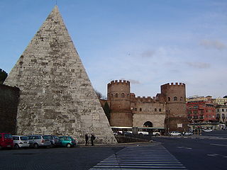
<span class="mw-page-title-main">Testaccio</span> Rione of Rome in Lazio, Italy

Testaccio is the 20th rione of Rome, identified by the initials R. XX, deriving its name from Monte Testaccio. It is located within the Municipio I.

<span class="mw-page-title-main">Parioli</span> Quartiere of Rome in Lazio, Italy

Parioli is the 2nd quartiere of Rome, identified by the initials Q. II.

<span class="mw-page-title-main">Prima Porta</span> Zona of Rome in Lazio, Italy

Prima Porta is the 58th zona of Rome, identified by the initials Z. LVIII. The name Prima Porta came from an arch of the aqueduct that brought water to the Villa of Livia, which formed over Via Flaminia a sort of gateway which travellers saw as the first indication of having reached Rome (Piperno).

<span class="mw-page-title-main">Ostia Antica (district)</span> District in Rome

Ostia Antica is the 35th zona of Rome, Italy, four kilometers away from the coast. It is identified by the initials Z. XXXV and it is distinct from Ostia. Ostia Antica belongs to Municipio X.

<span class="mw-page-title-main">Torrenova (Rome)</span> Zona of Rome in Lazio, Italy

Torrenova is the 16th zona of Rome, identified by the initials Z. XVI. It belongs partly to the Municipio VI and partly to the Municipio VII.

<span class="mw-page-title-main">Labaro</span> Zona of Rome in Lazio, Italy

Labaro is the 57th zona of Rome, identified by the initials Z. LVII. It is located 11 kilometres north of the city center, along the Via Flaminia, just outside the Grande Raccordo Anulare.

<span class="mw-page-title-main">Cesano (RM)</span> Zona of Rome in Lazio, Italy

Cesano is the 52nd zona of Rome, Italy, identified by the initials Z. LII. It takes its name from the small medieval village of Cesano di Roma, on the Via Cassia, which is located within the Municipio XV, 27 km from Rome proper.

<span class="mw-page-title-main">Settecamini</span> Zona of Rome in Lazio, Italy

Settecamini is the 6th zona of Rome, identified by the initials Z. VI.. Settecamini is also the name of the urban zone 5L, within the Municipio V of Rome.

<span class="mw-page-title-main">Via Cristoforo Colombo</span>

Via Cristoforo Colombo is a street in Rome (Italy) that links the historic centre to Ostia. Along most of its route, the street has three lanes for each direction of movement. With its 27 kilometres (17 mi) length it is the longest Italian road among those included within the borders of a single municipality and, in several stretches, the largest in Italy.

Colle Salario is a frazione of the Municipality of Rome (Italy), located in the zone Z. II Castel Giubileo, within the territory of the urban zone 4E Serpentara of the Municipio Roma III.

<span class="mw-page-title-main">Val Melaina</span> Zona of Rome in Lazio, Italy

Val Melaina is the 1st zona of Rome, identified by the initials Z. I, lying north of the city centre and covering an area of 6.2447 km².

<span class="mw-page-title-main">La Storta</span> Zona of Rome in Lazio, Italy

La Storta is the 51st zona of the Italian capital city, Rome. It is identified by the initials Z. LI and falls within the boundaries of Municipio XV.

<span class="mw-page-title-main">Portuense</span> Quartiere of Rome in Lazio, Italy

Portuense is the 11th quartiere of Rome (Italy), identified by the initials Q.XI.

<span class="mw-page-title-main">Giuliano-Dalmata</span> Quartiere of Rome in Lazio, Italy

Giuliano-Dalmata is the 31st quartiere of Rome, identified by the initials Q. XXXI. Its name refers to the Julian, Istrian and Dalmatian refugees that settled there in the postwar period.

<span class="mw-page-title-main">Ponte della Magliana</span> Bridge in Q.X Ostiense and Q.IX Portuense, Italy

Ponte della Magliana is a motorway bridge in Rome (Italy). It crosses the Tiber between Pian due Torri and Via del Cappellaccio, linking the Quartieri Portuense and Ostiense, respectively on the right and on the left of the river.
It is currently part of a larger viaduct, which continues on the right bank of the Tiber towards the Colli Portuensi urban zone and the highway to the Fiumicino Airport and on the left one towards the EUR district, the Tre Fontane urban zone and Via Laurentina.

Massimina is the urban zone 16E of Municipio XII of Rome. In a separate subdivision scheme, it belongs to zone "O" 20 A-B. Massimina is included in zone XLV Castel di Guido.

<span class="mw-page-title-main">Rome–Fiumicino railway</span>

The Rome–Fiumicino railway is an urban railway line in Rome.

<span class="mw-page-title-main">Tor Cervara</span> Zona of Rome in Lazio, Italy

Tor Cervara is the 7th zona of the Italian capital Rome, identified by the initials Z. VII. It belongs to the Municipio IV and has 13,975 inhabitants (2016). It is located in the east of the city, within the Grande Raccordo Anulare, and has an area of 5.9000 km2.

<span class="mw-page-title-main">Castel Giubileo</span> Zone of Rome in Lazio, Italy

Castel Giubileo is the second Zone of Rome in the Ager Romanus, identified as Z. II.

References

  1. Roma Capitale – Roma Statistica. Population inscribed in the resident register at 31 December 2016 by toponymy subdivision.
  2. Antonello Anappo. "Necropoli di Malnome". Arvalia Storia, 242.

Coordinates: 41°49′N12°21′E / 41.817°N 12.350°E / 41.817; 12.350