
Istria is the largest peninsula within the Adriatic Sea. The peninsula is located at the head of the Adriatic between the Gulf of Trieste and the Kvarner Gulf. It is shared by three countries: Croatia, Slovenia, and Italy, with 90% of surface area being part of Croatia. Croatia encapsulates most of the Istrian peninsula within Istria County.

Trieste is a city and seaport in northeastern Italy. It is the capital and largest city of the autonomous region of Friuli-Venezia Giulia, as well as of the regional decentralization entity of Trieste.

Aquileia is an ancient Roman city in Italy, at the head of the Adriatic at the edge of the lagoons, about 10 kilometres (6 mi) from the sea, on the river Natiso, the course of which has changed somewhat since Roman times. Today, the city is small, but it was large and prominent in classical antiquity as one of the world's largest cities with a population of 100,000 in the 2nd century AD and is one of the main archaeological sites of northern Italy. In late antiquity the city was the first city in the Italian Peninsula to be sacked by Attila the Hun.

Poreč is a town and municipality on the western coast of the Istrian peninsula, in Istria County, west Croatia. Its major landmark is the 6th-century Euphrasian Basilica, which was designated a UNESCO World Heritage Site in 1997.

Istria County is the westernmost county of Croatia which includes the majority of the Istrian peninsula.

Pula, also known as Pola, is the largest city in Istria County, Croatia, and the seventh-largest city in the country, situated at the southern tip of the Istrian peninsula in northwestern Croatia, with a population of 52,220 in 2021. It is known for its multitude of ancient Roman buildings, the most famous of which is the Pula Arena, one of the best preserved Roman amphitheaters. The city has a long tradition of wine making, fishing, shipbuilding, and tourism. It was the administrative centre of Istria from ancient Roman times until superseded by Pazin in 1991.

The Julian March, also called Julian Venetia, is an area of southeastern Europe which is currently divided among Croatia, Italy, and Slovenia. The term was coined in 1863 by the Italian linguist Graziadio Isaia Ascoli, a native of the area, to demonstrate that the Austrian Littoral, Veneto, Friuli, and Trentino shared a common Italian linguistic identity. Ascoli emphasized the Augustan partition of Roman Italy at the beginning of the Empire, when Venetia et Histria was Regio X.
The Austrian Riviera was a term used for advertising the seaside resorts on the Adriatic coast of the Austrian crown lands of Gorizia and Istria. The name arose with the emergence of tourism in the Austrian Littoral from the mid 19th century onwards and was common until the dissolution of the Austro-Hungarian Empire at the end of World War I.

The Parenzana in Italian and Croatian or Porečanka in Slovene is one of the nicknames of a defunct 760mm/15 15/16 inch narrow gauge railway between Trieste and Poreč, in present-day Italy, Slovenia and Croatia.

The Morgan Line was the line of demarcation set up after World War II in the region known as Julian March which prior to the war belonged to the Kingdom of Italy. The Morgan Line was the border between two military administrations in the region: the Yugoslav on the east, and that of the Allied Military Government on the west. After 15 September 1947, the Allied Military Government was composed of both the British Element Trieste Forces (BETFOR) troops from the United Kingdom and the Trieste United States Troops (TRUST) from the United States.

Nesactium was an ancient fortified town and hill fort of the Histri tribe. Its ruins are located in southern Istria, Croatia, between the villages of Muntić and Valtura.

The Via Ardeatina was an ancient road of Rome leading to the town of Ardea, after which it is named. Ardea lay 24 miles distant from Rome.
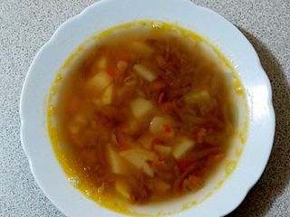
The jota or istrian stew is a soup made of beans, sauerkraut or sour turnip, potatoes, bacon, spare ribs, known in the northern Adriatic regions. Under the name jota it is typical and especially popular in Trieste and its province, in the Istrian peninsula, in the province of Gorizia, in the whole Slovenian Littoral, in the Rijeka area, and in Friuli, especially in some of its peripheral areas. The stew, based on etymology, most likely originated in Friuli before spreading east and south.

Province of Pola was a province of the Kingdom of Italy created after World War I, that officially existed from 1923 until 1947. The capital was Pola. After the Second World War the province of Pola became part of Yugoslavia. Following the collapse of Yugoslavia in 1991, the province of Pola has been part of Croatia and Slovenia.

The Raša in Croatian Istria is a major river of Croatia's Istria County. It is 23 kilometres (14 mi) long, and its basin covers an area of 279 km2 (108 sq mi). Its mouth is in the long ria of Raša Bay, which is a drowned river valley scoured out when world sea levels fell, then drowned by the rising waters of the post-glacial era. The Raša rises in springs near Pićan and flows south through a steep-sided valley before opening into the head of the Adriatic Sea. The river, although short in length, has an ancient history as a border.

Istrian Italians are an ethnic group from the Adriatic region of Istria in modern northwestern Croatia and southwestern Slovenia. Istrian Italians descend from the original Latinized population of Roman Histria, from the Venetian-speaking settlers who colonized the region during the time of the Republic of Venice, and from the local Croatian people who culturally assimilated.

D21 was an 80.1-kilometre-long (49.8 mi), north–south state road in Istria County, Croatia. A short section of D21 was a part of the European route E751. The northern terminus of the route was located at the Croatia–Slovenia border at the Dragonja River. There it connected to Koper, Slovenia, and Trieste, Italy, via the Slovene route G11 further north. The route was generally parallel to A9 motorway, with which it formed several junctions, either directly or via short connectors, at Buje, Bale and Vodnjan – towns served directly by D21. The southern terminus of the route was found in the city of Pula, at the southern tip of the Istrian Peninsula.

Italians of Croatia are an autochthonous historical national minority recognized by the Constitution of Croatia. As such, they elect a special representative to the Croatian Parliament. There is the Italian Union of Croatia and Slovenia, which is a Croatian-Slovenian joint organization with its main site in Rijeka, Croatia and its secondary site in Koper, Slovenia.

Maria Pasquinelli was an Italian teacher and member of the Fascist party convicted for the killing of British Brigadier Robert de Winton in Pola on 10 February 1947.

Labinština is the geographical and historical name of the eastern part of Istria county in Croatia. It covers an area of approximately 220 km2 that is 25 km long and 13 km wide. Geographical borders in the west are the Raša river, and the bay of the same name, in the south and east the sea, and in the north Plomin Bay, the southern part of the Učka massif and Kvarner Bay, and, until the beginning of the 20th century, Lake Čepić. The center is Labin after which it is named. Labin was the head township of the Labinština or Agro Albonese under the Roman Empire, during the Venice Republic between 1365 and 1797, the Austrian rule between 1814-1918 and many other occupations by foreign armies.
