
Pamplona, historically also known as Pampeluna in English, is the capital city of the Chartered Community of Navarre, in Spain.

Astorga is a municipality and city of Spain located in the central area of the province of León, in the autonomous community of Castilla y León, 43 kilometres (27 mi) southwest of the provincial capital. It is located in the transit between the Páramo Leonés and the mountains of León and acts as the backbone of the comarcas of Maragatería, La Cepeda and the Ribera del Órbigo. The city is the head of one of the most extensive and oldest dioceses of Spain, whose jurisdiction covers half of the province of León and part of Ourense and Zamora. It is also head of the judicial party number 5 of the province of León.

Watling Street is a historic route in England that crosses the River Thames at London and which was used in Classical Antiquity, Late Antiquity, and throughout the Middle Ages. It was used by the ancient Britons and paved as one of the main Roman roads in Britannia. The route linked Dover and London in the southeast, and continued northwest via St Albans to Wroxeter. The line of the road was later the southwestern border of the Danelaw with Wessex and Mercia, and Watling Street was numbered as one of the major highways of medieval England.
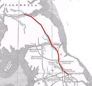
Dere Street or Deere Street is a modern designation of a Roman road which ran north from Eboracum (York), crossing the Stanegate at Corbridge and continuing beyond into what is now Scotland, later at least as far as the Antonine Wall. It was the Romans' major route for communications and supplies to the north and to Scotland. Portions of its route are still followed by modern roads, including the A1(M), the B6275 road through Piercebridge, where Dere Street crosses the River Tees, and the A68 north of Corbridge in Northumberland.

The Antonine Itinerary is an itinerarium, a register of the stations and distances along various roads. Seemingly based on official documents, possibly in part from a survey carried out under Augustus, it describes the roads of the Roman Empire. Owing to the scarcity of other extant records of this type, it is a valuable historical record.

Legio VII Gemina was a legion of the Imperial Roman army. It was raised in AD 68 in Hispania by the general Galba to take part in his rebellion against the emperor Nero. "Gemina" means the legion was dedicated to the legendary twin founders of Rome, Romulus and Remus, who were suckled by a she-wolf. The legion was deployed in the city called Legio in AD 74 and remained in Hispania to the end of the 4th century.
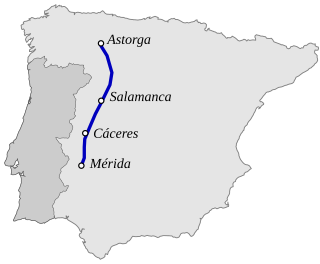
The Vía de La Plata or Ruta de la Plata is an ancient commercial and pilgrimage path that crosses the west of Spain from north to south, connecting Mérida to Astorga. An extended form begins further south in Seville and reaches north to the Bay of Biscay at Gijón. The path is used by the modern A-66 and AP-66 freeways, as well as by the older N-630 national road.

The Via Augusta was the longest and busiest of the major roads built by the Romans in ancient Hispania. According to historian Pierre Sillières, who has supervised excavation of Roman sites in Spain to identify the exact route followed by the Via Augusta, it was more a system of roads than a single road. Approximately 1,500 km (930 mi) long, the Via Augusta was built to link Spain with Italy, running from the southwestern coastal city of Gades (Cádiz) to the Pyrenees Mountains along inland valleys parallel to the coast of the Mediterranean Sea. As the main axis of the road network in Roman Hispania, it appears in ancient sources such as the itinerary inscribed on the Vicarello Cups as well in as the Antonine Itinerary.

A Rúa is a mostly rural municipality in the province of Ourense, in the autonomous community of Galicia, Spain. It belongs to the comarca of Valdeorras. It is 101 km (63 mi) from the provincial capital, Ourense. An inhabitant of the area is known as a rués.

O Barco de Valdeorras is a municipality in the province of Ourense, in the autonomous community of Galicia, Spain. It belongs to the comarca of Valdeorras, serving as its capital. It is located in the Sil valley and lying in the Serra do Eixo. One of its economic foundations, besides mining and slate processing, is wine production, which qualified for the Designation of Origin Valdeorras. Remains of Roman and pre-Roman culture and several stately manor houses are the most important monuments in the town. It is also famous for its wines.

Arancón is a municipality in the province of Soria, Spain, located at the foot of the mountain range of El Almuerzo and Mount Cencejo. The localities that make up the municipality are Arancón, Tozalmoro, Omeñaca, Calderuela, Nieva de Calderuela and Cortos.
The Via Annia was the Roman road in Venetia in north-eastern Italy. It run on the low plains of the lower River Po and of the lower Veneto and Friuli-Venezia Giulia regions, an area which had many rivers and large marsh areas and bordered the coastal lagoons. It linked Atria to Aquileia, passing through Patavium. Then it got to the mainland coast of the Lagoon of Venice near today's Mestre and passed through Altinum. After this, it went through Iulia Concordia, which was further inland. It was paved only through the main towns. The rest was gravelled. It was six to eighteen metre wide. It played an important part in the Romanization of the region.

Arkaia is a hamlet on the eastern side of Vitoria in the Basque province of Álava. In 2017 it had 78 inhabitants.
Caenophrurium was a settlement in the Roman province of Europa, between Byzantium and Heraclea Perinthus. It appears in late Roman and early Byzantine accounts. Caenophrurium translates as the "stronghold of the Caeni", a Thracian tribe.
Petavonium was a Roman Legionary Fortress (castrum) of the Legio X Gemina, and later a Roman city formed from the canabae, or civilian camp. It was located in the valley of Vidriales in an area of the modern Santibanez de Vidriales and its hamlet Rosinos de Vidriales, in the province of Zamora.
Iturissa was a Roman town in north-west Spain in the province of Hispania Tarraconensis, now the province and autonomous community of Navarre. Iturissa was mentioned by Ptolemy in the second century as "a town of the Vascones."

The Via Nova or Via XVIII in the Antonine Itinerary is a Roman road which linked the cities of Bracara Augusta and Asturica Augusta, with a length of about 210 roman miles.
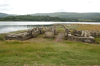
Aquis Querquennis is a Roman fort in Ourense Province, Galicia. It was constructed circa 69-79 AD to house soldiers building the Via XVIII and was occupied by the Legio VII Gemina until that unit was posted to Dacia in 120 AD and the fort abandoned. The fort was rediscovered in the 1920s and some excavations carried out by local archaeologist Florentino López Cuevillas. In 1949 the site was flooded by construction of the As Conchas reservoir. Since 1975 excavations have been carried out on the fort during periods when the reservoir level falls.
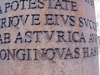
Asturica Augusta was a Roman city corresponding to the Spanish city of Astorga, in the province of León. Founded around 14 B.C. as a camp of the Legio X Gemina, at the beginning of the first century it developed as a civil center and was the capital of the Asturicense conventus iurudicus, within the province of Tarraconense.

The item to Laminio, alio itinere Cæsarea Augusta, as it appears in the original document, or Antonine Itinerary A-31, according to the nomenclature adopted by Saavedra to classify the Roman roads of Hispania that appear in that document, is a communication route of Ancient Rome through the current Iberian Peninsula. Of all the Hispanic Itineraries, this is one of the most difficult to reconstruct since most of its points of passage have not yet been fully established, among them Laminio, the city of origin, and there are notable discrepancies within the scientific community.

