Via Valeria

Last updated
Via Tiburtina/Valeria in pink Viae Salaria Tiburtina map.jpg
Via Tiburtina/Valeria in pink
Via Valeria Voievalerienne planlatium.jpg
Via Valeria

The Via Valeria was an ancient Roman road of Italy, the continuation north-eastwards of the Via Tiburtina from Tibur. It probably owed its origin to Marcus Valerius Messalla, censor in 154 BC. [1]

Contents

The route

It ran first up the Anio valley past Varia, and then leaving the Anio at the 36th mile, where the Via Sublacensis joined it, ascended to Carsoli and to the lofty pass of Monte Bove, whence it descended again to the valley occupied by the Lake Fucino in Roman times. It is doubtful whether, before Claudius, the Via Valeria ran farther than Cerfennia, the eastern point of the territory of the Marsi, to the northeast of Lake Fucino. Strabo states that in his day it went as far as Corfinium, and this important place must have been accessible from Rome, but probably beyond Cerfennia only by a track. [2] [3] [4]

At the Roman statio ad Lamnas (at Cineto Romano) it split into two routes, the Valeria vetus and Valeria nova, which reunited near Riofreddo. [5] [6] The vetus was older as it was a military road that later became a more difficult shortcut when the nova became the longer but easier main road. [7]

On the prolongation beyond Cerfennia, a milestone (Corp. Inscr. Lat. IX. 5973) states that in 48-49 AD Claudius made the Via Claudia Valeria from Cerfennia to the mouth of the Aternus (the site of modern Pescara). This difficult part of the road to the valley of the Aternus involved a drop of nearly 300 m and the crossing of the main ridge of the Apennines by the modern Forca Caruso. From Popoli the road followed the valley of the Aternus to its mouth, and there joined the coast-road at Pescara. The modern railway from Rome to Castellammare Adriatico follows closely the line of the Via Valeria. [2] He also constructed a road, the Via Claudia Nova connecting the Via Salaria to the Via Valeria near the modern Popoli. This road was continued south to Isernia.

Since 2000 the Ponte Scutonico, the most important and well-preserved monument of the Via Valeria in the Aniene valley which had been buried after floods and landslides, has been excavated with the enhancement of the stretch of road belonging to it leading to a considerable advance in knowledge. It was probably built under Nerva (r. 96-8) along with enhancement of the road.

Other roads

A second Via Valeria, the Via Valeria of Sicily, connected Messina and Siracusa. Hardly widened or improved until the nineteenth century, it remained the backbone of the Ionian drainage basin of Sicily, favouring the development of cities along it: Messina, Taormina, Giardini-Naxos, Giarre, Acireale, Catania, Augusta, Siracusa. Today, Route 114 follows it in part.[ citation needed ]

Roman bridges

Ponte Scutonico Ponte Scutonico.png
Ponte Scutonico

There are the remains of at least two Roman bridges along the road, which are the Ponte San Giorgio and the Ponte Scutonico.

See also

Related Research Articles

<span class="mw-page-title-main">Via Clodia</span>

The Via Clodia was an ancient high-road of Italy. Situated between the Via Cassia and the Via Aurelia, it is different from them notably in that the latter was designed primarily for military long-haul, irrespective of settlements they met, but the Via Clodia was of short-range, intended for commercial traffic with the colonies in Etruscan lands.

<span class="mw-page-title-main">Aniene</span> River in Lazio, Italy

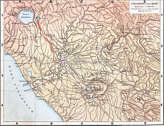
The Aniene, formerly known as the Teverone, is a 99-kilometer (62 mi) river in Lazio, Italy. It originates in the Apennines at Trevi nel Lazio and flows westward past Subiaco, Vicovaro, and Tivoli to join the Tiber in northern Rome. It formed the principal valley east of ancient Rome and became an important water source as the city's population expanded. The falls at Tivoli were noted for their beauty. Historic bridges across the river include the Ponte Nomentano, Ponte Mammolo, Ponte Salario, and Ponte di San Francesco, all of which were originally fortified with towers.

<span class="mw-page-title-main">Via Praenestina</span>

The Via Praenestina was an ancient Roman road in central Italy.

<span class="mw-page-title-main">Avezzano</span> Comune in Abruzzo, Italy

Avezzano is a city and comune with a population of 40,661 inhabitants, situated in the Abruzzo region, province of L'Aquila, Italy. It is the second most populous municipality in the province and the sixth in the region. Avezzano was documented as an existing urban center in the ninth century. The city was destroyed by the earthquake of 1915. It was rebuilt after the 1944 Allied bombing. The city was decorated with the silver medal for civil merit, an award granted by the Italian Republic.

<span class="mw-page-title-main">Via Tiburtina</span>

Via Tiburtina is an ancient road in Italy leading east-northeast from Rome to Tivoli and then, with the via Valeria, on to Pescara.

<span class="mw-page-title-main">Corfinium</span> Ancient Italian city

Corfinium was a ancient city now near modern Corfinio, in the province of L'Aquila.

<span class="mw-page-title-main">Lucos Cozza</span> Italian archaeologist (1921–2011)

Lucos Cozza was an italian Roman archaeologist.

<span class="mw-page-title-main">Aqua Anio Novus</span> Ancient Roman aqueduct in Italy

Aqua Anio Novus was an ancient Roman aqueduct supplying the city of Rome. Like the Aqua Claudia, it was begun by emperor Caligula in 38 AD and completed in 52 AD by Claudius, who dedicated them both on August 1.

<span class="mw-page-title-main">Aqua Claudia</span> Ancient Roman aqueduct in Italy

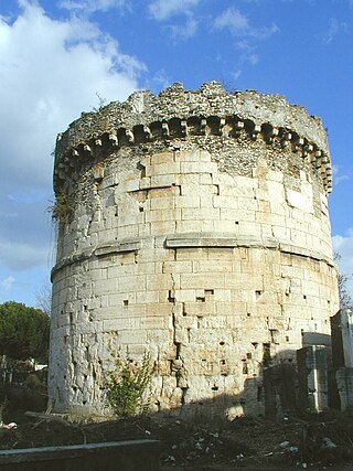
Aqua Claudia was an ancient Roman aqueduct that, like the Aqua Anio Novus, was begun by Emperor Caligula in 38 AD and finished by Emperor Claudius in 52 AD.

<span class="mw-page-title-main">Abruzzo Airport</span> Airport in Pescara, Italy

Abruzzo Airport is an international airport serving Pescara, Italy. It is located approximately 4 km from the centre of Pescara, about 180 km from Rome, a 2-hour drive by car on a motorway across the Apennine mountains. The airport is located on the state road 5 Via Tiburtina Valeria and is well connected to important road and railway connections.

<span class="mw-page-title-main">Temple of Minerva Medica (nymphaeum)</span> Ancient religious monument in Rome, Italy

The Temple of Minerva Medica is a ruined nymphaeum of Imperial Rome which dates to the 4th century CE. It is located between the Via Labicana and Aurelian Walls and just inside the line of the Anio Vetus. Once part of the Horti Liciniani on the Esquiline Hill, it now faces the modern Via Giolitti. It was once thought to be the temple to Minerva Medica mentioned by Cicero and other sources.

<span class="mw-page-title-main">Aternum</span>

Aternum was a Roman town, on the site of Pescara, in Italy. Some historians also refer to Aternum with the name of Ostia Aterni, due to its location at the mouth of the river Aternus. Being connected to Rome through the Via Tiburtina and its extension the Via Valeria, Aternum played a crucial in connecting the capital to the Eastern provinces of the Empire. Its harbour, largely occupied by commercial and fishing ships, was supposedly also used for military purposes.

<span class="mw-page-title-main">Settecamini</span> Zona of Rome in Lazio, Italy

Settecamini is the 6th zona of Rome, identified by the initials Z. VI.. Settecamini is also the name of the urban zone 5L, within the Municipio V of Rome.

The Via Sublacensis was a Roman road constructed to connect Nero's palace in present-day Subiaco to Rome, splitting off from the Via Valeria near Varia, about 10 km northeast of Tivoli.

<span class="mw-page-title-main">Aqua Marcia</span> Ancient Roman aqueduct, built 144–140 BC

The Aqua Marcia is one of the longest of the eleven aqueducts that supplied the city of Rome. The aqueduct was built between 144–140 BC, during the Roman Republic. The still-functioning Acqua Felice from 1586 runs on long stretches along the route of the Aqua Marcia.

<span class="mw-page-title-main">FL2 (Lazio regional railways)</span>

The FL2 is a regional rail route forming part of the Lazio regional railways network, which is operated by Trenitalia, and converges on the city of Rome, Italy.

<span class="mw-page-title-main">Aqua Anio Vetus</span>

The Aqua Anio Vetus was an ancient Roman aqueduct, and the second oldest after the Aqua Appia.

<span class="mw-page-title-main">Tunnels of Claudius</span> Italian archaeological site

The Tunnels of Claudius consist principally of a 6 km-long tunnel together with several monumental service tunnels which Roman Emperor Claudius had built by 52 AD to partially drain the Fucine Lake in Abruzzo, protecting riparian villages from floods and creating agricultural land. It was a massive engineering project involving 30000 workmen and slaves who completed it in just 11 years, and considered among the grandest in antiquity. It was the longest tunnel ever built until the inauguration of the Fréjus Rail Tunnel in 1871.

<span class="mw-page-title-main">Municipio VII</span> Municipio of Rome in Lazio, Italy

Municipio Roma VII is the seventh administrative subdivision of the Municipality of Rome (Italy).

References

  1. Wade, J. (2022). EXPEDITIONS FROM ROME: THOMAS ASHBY, HIS BSR COMPANIONS AND THE ROMAN ROADS OF ITALY. Papers of the British School at Rome, 90, 267-295. doi:10.1017/S0068246221000246
  2. 1 2 Wikisource-logo.svg One or more of the preceding sentences incorporates text from a publication now in the public domain :  Ashby, Thomas (1911). "Valeria, Via". In Chisholm, Hugh (ed.). Encyclopædia Britannica . Vol. 27 (11th ed.). Cambridge University Press. Ashby cites E. Albertini in Mélanges de l’École française de Rome (1907), 463 sqq.
  3. Bunbury, Edward Herbert (1872). "Via Valeria". In Smith, William (ed.). Dictionary of Greek and Roman Geography. London: Walton & Murray. pp. 1305–1307.
  4. Evans, Harry B. (2002). Aqueduct Hunting in the Seventeenth Century: Raffaello Fabretti's De Aquis Et Aquaeductibus Veteris Romae. Ann Arbor, MI: University of Michigan Press. p. 169. ISBN   978-0-472-11248-7.
  5. Zaccaria Mari, Intervento di recupero dell’antica via Valeria e del ponte Scutonico nel territorio di Roviano (Roma), Inaugurazione dell’Area archeologica di Ponte Scutonico lungo il percorso naturalistico della Via Valeria antica e della nuova esposizione archeologica nel Palazzo Brancaccio Roviano (Rm), Via Tiburtina-Valeria km 56.800 (Ponte Scutonico) - Comune di Roviano e Soprintendenza per i Beni Archeologici del Lazio, 29 marzo 2014 - Inaugurazione
  6. La via Valeria romana nella valle dell’Aniene https://blogcamminarenellastoria.wordpress.com/2019/08/27/la-via-valeria-romana-nella-valle-dellaniene/
  7. C. C. van Essen, The Via Valeria from Tivoli to Collarmele, Papers of the British School at Rome, Vol. 25 (1957), pp. 22-38 (22 pages), http://www.jstor.org/stable/40310566