The Via Campana (Italian - Via Antica Consolare campana) was one of the main roads of the Roman Empire. It begins at the Flavian Amphitheatre at Pozzuoli and ran through several ancient craters, passing the town of Qualiano and ending in Ancient Capua at junction with the via Appia.
In XIX was created the New via Campana that has similar path but it ends at junction with the diramation of via Appia in the town of Giugliano.
Four kilometres from Pozzuoli it crosses the craters of the Quarto Flegreo that give their name to the nearby town of Quarto and cross through the Montagna Spaccata, literally a cut through the wall of the crater made by the Romans to allow the road to cross to the opposite side of the crater (where the road climbs along the slopes instead). The Montagna Spaccata passage is now perfectly preserved and used as the main road in and out of the town. The bricks put in by the Romans to prevent the crater wall from collapsing can still be seen in excellent states of preservation all along the passage. Various Roman catacombs and necropolises can also be seen along the route.
Roman roads were physical infrastructure vital to the maintenance and development of the Roman state, built from about 300 BC through the expansion and consolidation of the Roman Republic and the Roman Empire. They provided efficient means for the overland movement of armies, officials, civilians, inland carriage of official communications, and trade goods. Roman roads were of several kinds, ranging from small local roads to broad, long-distance highways built to connect cities, major towns and military bases. These major roads were often stone-paved and metaled, cambered for drainage, and were flanked by footpaths, bridleways and drainage ditches. They were laid along accurately surveyed courses, and some were cut through hills or conducted over rivers and ravines on bridgework. Sections could be supported over marshy ground on rafted or piled foundations.
The Appian Way is one of the earliest and strategically most important Roman roads of the ancient republic. It connected Rome to Brindisi, in southeast Italy. Its importance is indicated by its common name, recorded by Statius, of Appia longarum... regina viarum . The road is named after Appius Claudius Caecus, the Roman censor who, during the Samnite Wars, began and completed the first section as a military road to the south in 312 BC.
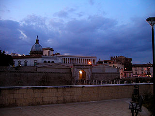
Capua is a city and comune in the province of Caserta, in the region of Campania, southern Italy, situated 25 km (16 mi) north of Naples, on the northeastern edge of the Campanian plain.
Ostia Antica is an ancient Roman city and the port of Rome located at the mouth of the Tiber. It is near modern Ostia, 25 km (16 mi) southwest of Rome. Due to silting and the invasion of sand, the site now lies 3 km (2 mi) from the sea. The name Ostia derives from Latin os 'mouth'.
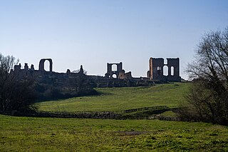
Cumae was the first ancient Greek colony of Magna Graecia on the mainland of Italy and was founded by settlers from Euboea in the 8th century BCE. It became a rich Roman city, the remains of which lie near the modern village of Cuma, a frazione of the comune Bacoli and Pozzuoli in the Metropolitan City of Naples, Campania, Italy.
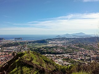
Pozzuoli is a city and comune (municipality) of the Metropolitan City of Naples, in the Italian region of Campania. It is the main city of the Phlegrean Peninsula.
The Phlegraean Fields is a large caldera volcano west of Naples, Italy. It is part of the Campanian volcanic arc, which includes Mount Vesuvius, about 9 km east of Naples. The Phlegraean Fields is monitored by the Vesuvius Observatory. It was declared a regional park in 2003.
The Via Latina was a Roman road of Italy, running southeast from Rome for about 200 kilometers.
Terracina is an Italian city and comune of the province of Latina, located on the coast 56 km (35 mi) southeast of Rome on the Via Appia. The site has been continuously occupied since antiquity.
Autostrada A90 or Grande Raccordo Anulare or GRA is a ring-shaped autostrada 68.2 kilometres (42.4 mi) long in Italy located in the region of Lazio that encircles Rome. It is a part of the E80 European route. GRA is one of the most important roads in Rome, and traffic reaches 160,000 vehicles per day as of 2011.
Parete is a comune (municipality) in the Province of Caserta in the Italian region Campania, located about 15 kilometres (9 mi) northwest of Naples and about 20 kilometres (12 mi) southwest of Caserta. As of 31 December 2004, it had a population of 10,597 and an area of 5.7 square kilometres (2.2 sq mi).
Marano di Napoli is a comune (municipality) in the Metropolitan City of Naples in the Italian region of Campania, located about 9 kilometres northwest of Naples. Partly located on the Camaldoli hill, it is one of the most populous municipalities in the metropolitan city.
The Tomb of the Scipios, also called the hypogaeum Scipionum, was the common tomb of the patrician Scipio family during the Roman Republic for interments between the early 3rd century BC and the early 1st century AD. Then it was abandoned and within a few hundred years its location was lost.
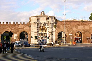
Porta San Giovanni is a gate in the Aurelian Wall of Rome, Italy, named after the nearby Archbasilica of Saint John Lateran.
Via Asinaria was an ancient Roman road that started from Porta Asinaria in the Aurelian walls (Rome). It was somehow connected with the Via Latina, as it is reported that Belisarius, during its advance on Rome, left the Via Latina to enter the city from Porta Asinaria; the latter was considered one of the main accesses for those coming from the south, as in ancient times the 17th-century Porta San Giovanni didn't exist.
The Villa of the Quintilii is a monumental ancient Roman villa beyond the fifth milestone along the Via Appia Antica just outside the traditional boundaries of Rome, Italy. It was built by the rich and cultured Quintilii brothers Sextus Quintilius Valerius Maximus and Sextus Quintilius Condianus.
The Appian Way Regional Park is the second-largest urban park of Europe, after Losiny Ostrov National Park in Moscow. It is a protected area of around 4580 hectares, established by the Italian region of Latium. It falls primarily within the territory of Rome but parts also extend into the neighbouring towns of Ciampino and Marino. The peculiarity of the park that distinguishes it, is that it also hosts the Archaeological park of Appia Antica, which coincides with the perimeter of the regional park itself. It is a monumental park which contains precious legacies of ancient Rome, including the Appian Way, various Roman aqueducts, Roman villas, mausoleums, catacombs.
The Hypogeum of Vibia is part of a small complex of pagan burial chambers in Rome which were constructed along the Via Appia in the late 4th century CE. It is named for the burials of a woman named Vibia and her husband Vincentius, a priest of the Thraco-Phrygian god Sabazios. The hypogeum is notable for the paintings that show the deceased figures in mythological scenes and in the underworld, and for their accompanying inscriptions. Numerous other decorated tombs and inscriptions were found in the complex.
Appio-Latino is the 9th quartiere of Rome (Italy), identified by the initials Q. IX. The name derives from the ancient roads Via Appia and Via Latina. It belongs to the Municipio VII and Municipio VIII.
The Via Flacca was a Roman road along the western coast of Latium, Italy. It was built under censor Lucius Valerius Flaccus around 184 BC. Parts of it have recently been renovated as a trekking route.
This page is based on this Wikipedia article Text is available under the CC BY-SA 4.0 license; additional terms may apply. Images, videos and audio are available under their respective licenses.