
Surrey is a ceremonial county in South East England and one of the home counties. It is bordered by Greater London to the northeast, Kent to the east, East and West Sussex to the south, and Hampshire and Berkshire to the west. The largest settlement is Woking.

Reigate and Banstead is a local government district with borough status in east Surrey, England. It includes the towns of Reigate, Redhill, Horley and Banstead. The borough borders the Borough of Crawley to the south, the Borough of Epsom and Ewell and District of Mole Valley to the west, Tandridge District to the east and the London Boroughs of Sutton and Croydon to the north.
Reigate is a town in Surrey, England, around 19 miles (30 km) south of central London. The settlement is recorded in Domesday Book in 1086 as Cherchefelle and first appears with its modern name in the 1190s. The earliest archaeological evidence for human activity is from the Paleolithic and Neolithic, and during the Roman period, tile-making took place to the north east of the modern centre.

Redhill is a town in the borough of Reigate and Banstead within the county of Surrey, England. The town, which adjoins the town of Reigate to the west, is due south of Croydon in Greater London, and is part of the London commuter belt. The town is also the post town, entertainment and commercial area of three adjoining communities : Merstham, Earlswood and Whitebushes, as well as of two small rural villages to the east in the Tandridge District, Bletchingley and Nutfield.
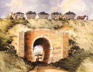
The Surrey Iron Railway (SIR) was a horse-drawn plateway that linked Wandsworth and Croydon via Mitcham, all then in Surrey but now suburbs of south London, in England. It was established by Act of Parliament in 1801, and opened partly in 1802 and partly in 1803. It was a toll railway on which carriers used horse traction. The chief goods transported were coal, building materials, lime, manure, corn and seeds. The first 8.25 miles (13.28 km) to Croydon opened on 26 July 1803, with a branch line off from Mitcham to Hackbridge.
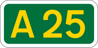
The A25 road is an east–west main road in the South-East of England. Its carries traffic east from Guildford, Surrey, eastward through Surrey and into mid-west Kent, to the town of Sevenoaks, and then on to Wrotham Heath where it connects with the A20.
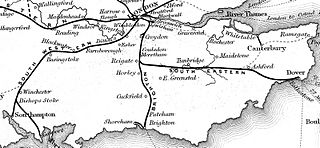
The London and Brighton Railway (L&BR) was a railway company in England which was incorporated in 1837 and survived until 1846. Its railway ran from a junction with the London and Croydon Railway (L&CR) at Norwood – which gives it access from London Bridge, just south of the River Thames in central London. It ran from Norwood to the South Coast at Brighton, together with a branch to Shoreham-by-Sea.
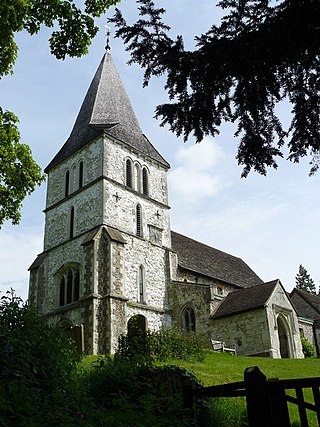
Merstham is a town in the borough of Reigate and Banstead in Surrey, England. It lies 17 miles south of Charing Cross just beyond the Greater London border. Part of the North Downs Way runs along the northern boundary of the town. Merstham has community associations, an early medieval church and a football club.

The North Downs Line is a passenger-train line connecting Reading to Redhill and Gatwick Airport, along the Brighton Main Line, linking many centres of population in that part of the North Downs which it traverses en route.

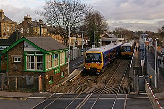
Redhill railway station serves the town of Redhill, Surrey, England. The station is a major interchange point on the Brighton Main Line, 22 miles 40 chains (36.2 km) measured from London Charing Cross. It is managed by Southern, and is also served by Thameslink and GWR.

Earlswood is a suburb of Redhill in Surrey, England, which lies on the A23 between Redhill and Horley. Earlswood Common is a local nature reserve that separates the suburb from the southern outskirts of Reigate and has two lakes and picnic areas. Earlswood station is on the Brighton Main Line. To the east of the line are Royal Earlswood Park, the East Surrey Hospital and Whitebushes.

Meadvale or less commonly Mead Vale is a southern residential suburb that straddles borders of Redhill and Reigate in the borough of Reigate and Banstead in Surrey, and one of two which do so. The average elevation of the district is higher than the centres of each of the towns – Meadvale is bisected east-west by the Greensand Way at the top of a moderately low section of the Greensand Ridge. Its population, as broadly defined on its ward definition, is 3,090 spread over 64 hectares based upon the most recent national census.

Betchworth is a village and civil parish in the Mole Valley district of Surrey, England. The village centre is on the north bank of the River Mole and south of the A25 road, almost 3 miles (4.8 km) east of Dorking and 3 miles (4.8 km) west of Reigate. London is 19.5 miles (31.4 km) north of the village.

Buckland is a village and civil parish in the Mole Valley district of Surrey, England, between Dorking and Reigate, its nearest towns. The civil parish is bordered by the North Downs escarpment in the north. The area contains a number of sand pits.
Reigate railway station serves the town of Reigate, Surrey, England, on the North Downs Line. It is 24 miles 27 chains measured from London Charing Cross via Redhill. The station is managed by Southern.

Reigate Castle is a former castle in the town of Reigate in the county of Surrey, England. None of the castle buildings survive today, but a cave below the site, considered to be part of the castle, still exists. Known as "Baron's Cave", it is occasionally open to the public for tours.
Dunottar School is an independent school in Reigate, Surrey, England, established in 1926.

Reigate Town Hall is a municipal building in Castlefield Road, Reigate, Surrey, England. The town hall, which is the meeting place of Reigate and Banstead Borough Council, is a Grade II listed building.

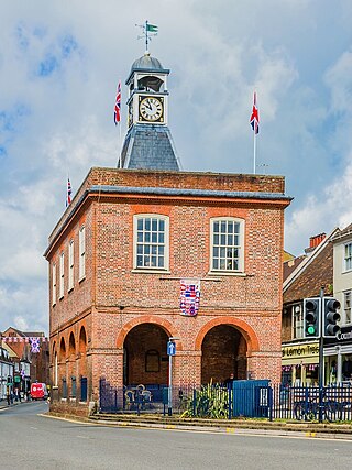
The Old Town Hall is a municipal building in the High Street, Reigate, Surrey, England. It is a Grade II* listed building.
