Reipoltskirchen Castle

Last updated
Reipoltskirchen Castle
Burg Reipoltskirchen
Reipoltskirchen
Wasserburg reipoltskirchen.jpg
Reipoltskirchen Water Castle
Rhineland-Palatinate location map.svg
Red pog.svg
Reipoltskirchen Castle
Germany adm location map.svg
Red pog.svg
Reipoltskirchen Castle
Coordinates 49°38′6.5″N7°39′48.7″E / 49.635139°N 7.663528°E / 49.635139; 7.663528 Coordinates: 49°38′6.5″N7°39′48.7″E / 49.635139°N 7.663528°E / 49.635139; 7.663528
Type lowland castle and settlement
CodeDE-RP
Height208 m above  sea level (NHN)
Site information
Conditionlargely preserved
Site history
Built1100 to 1200
Materials sandstone
Garrison information
Occupantsnobility
Peter Gayer, Reipoltskirchen Castle around 1830 (second oldest known depiction) Gayer Burg Reipoltskirchen.jpg
Peter Gayer, Reipoltskirchen Castle around 1830 (second oldest known depiction)

Reipoltskirchen Castle (German : Wasserburg Reipoltskirchen) is a water castle in the parish of Reipoltskirchen in the county of Kusel in the German state of Rhineland-Palatinate. It is one of the best preserved water castles in the Palatinate region.

Contents

The castle stands at a height of 208 metres above sea level (NN) on the site of an artificially created earth hillock around a rock spur on the Odenbach river.

History

As early as 1198, the first related nobleman, Meffried of Reipoltskirchen, is mentioned, so the castle could have existed at that time. However, the first record of a castle in Reipoltskirchen, castro Ripoltskirchen, does not appear until 1276, when the fortification came into the possession of Theoderich (Dietrich) of Hohenfels. The "von Hohenfels" were a branch of the lords of Bolanden, who later called themselves "lords of Reipoltskirchen" in a new branch of the Hohenfels family. When the Hohenfels family seat was destroyed in 1351, the family of the older line probably temporarily sought refuge with their cousin, Conrad, in the water castle of Reipoltskirchen. The last Hohenfels of the older line sold the remainder of his estate due to poverty and "meagre sustenance" (notturfft lipplicher narung) and had to spend the rest of his life in a house belonging to the Neuenbaumburg near his relatives, the Raugrave of Bolanden.

In 1401, Nicholas Vogt of Hunolstein used the castle, which was part of the dower of his wife, Ida of Erbach, as a base during an armed confrontation with Duke Charles of Lorraine. The duke besieged the castle and captured it. Nicholas, who also called himself Lord of Hunolstein, and his stepson, Eberhard of Hohenfels, Lord of Reipoltskirchen, concluded an expiatory treaty with Duke Charles on 27 March 1401. Temporarily, a quarter of the castle and estate had to be ceded to Lorraine. The Vogt of Hunolstein experienced additional humiliation and was appointed as administrator of the Lorraine share in the castle (Sloss Ripoltzkirchen).

At the beginning of the 16th century the castle was probably expanded by the brothers John (ally of Francis of Sickingen) and Wolfgang of Hohenfels-Reipoltskirchen. John II, to whom this extension had hitherto been attributed, was still a child at the time and only appears in the records from 1538 to 1570. [1]

The von Hohenfels line died out with John III (grandson of John II) in 1602. In accordance with a 1603 clause in the will by Countess Amalia, the mother of the last member of the Hohenfels family, the castle passed after her death in 1608 to her two brothers Emich and Sebastian, counts of Daun-Falkenstein. However, these two passed away without any descendants entitled to inherit (living heirs), so the castle and the estate of Countess Amalia went to her two nephews, sons of her sister, Sidonia, the Swedish counts John-Casimir and Sten (Steino) of Löwenhaupt-Rasburg, cousins (great cousins) of the Swedish king, Gustavus II Adolphus of the House of Wasa. Stens's half of the castle and estate went to the counts of Manderscheid-Kail by marriage and inheritance. In 1730, Count Francis William Caspar was able to acquire this half share from Hillesheim. The other half of the estate of John-Casimir remained in the possession of the counts of Löwenhaupt-Rasburg until 1763 and was subsequently sold to Count Philip Andrew of Ellrodt.

In 1770/1773, an attempt was made to sell Ellrodt's share of the estate to Palatinate-Zweibrücken, which failed, however, because of unnoted pre-emptive rights.

In 1777/1778 the estate was managed by Count William Ernest Godfrey of Hillesheim and Princess Caroline of Isenburg, daughter of Palatine Elector, Charles Theodore in condominium. In 1797 the property was expropriated as part of the French occupation. On 30 November 1808, the castle grounds and its buildings were auctioned off to Karl Baumann, the Maire of Lauterecken, merchant Heinrich Puricelli and farmer Johann Bacher. A short time later, in 1836, the buildings were described as ruinous because they were partly used as quarries. Around 1830, the Speyer district archivist, Peter Gayer (1793-1836), captured the state of the castle in a sepia drawing, the second oldest known painting of the castle. [2] The oldest depiction of the castle is by Freiherr Stephan von Stengel. It is an etching which he titled with "à ReipoldsKirchen" and signed with a French name "p. Et. de Stengel 1772 ". The castle is, depicted in a ruinous state, was probably drawn from the north. Stengel's etching could also combine views from different angles.

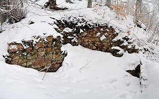
Most of the heart of castle site was acquired in 1988 by the county of Kusel. The castle underwent extensive renovation in 2005. Today it houses a restaurant, a registry office and an art school. The bergfried is freely accessible and has been turned into a viewing tower.

Baronetcy of Reipoltskirchen

Reipoltskirchen Castle was the seat of the eponymous imperially immediate Herrschaft or baronetcy.

The Herrschaft eventually consisted of the following 15 villages: [3]

Reipoltskirchen, Berzweiler, Dörnbach, Finkenbach, Gersweiler, Hefersweiler, Moorbach, Niederkirchen, Nußbach, Rathskirchen, Reichsthal, Rölsberg, Rudolphskirchen, Schönborn and Seelen.

Site

The surviving elements of the sandstone castle are the 17-metre-high bergfried and the curtain walls. The rooms added since the 1970s are used today as an art school.

Related Research Articles

<span class="mw-page-title-main">Rupert, King of the Romans</span> 15th century King of Germany

Rupert of the Palatinate, sometimes known as Robert of the Palatinate, a member of the House of Wittelsbach, was Elector Palatine from 1398 and King of Germany from 1400 until his death.

<span class="mw-page-title-main">Palatinate (region)</span> Historical region of Germany

The Palatinate is a region of Germany (Deutschland). In the Middle Ages it was known as the Rhenish Palatinate (Rheinpfalz) and Lower Palatinate (Unterpfalz), which strictly speaking designated only the western part of the Electorate of the Palatinate, as opposed to the Upper Palatinate (Oberpfalz). It occupies roughly the southernmost quarter of the German federal state of Rhineland-Palatinate (Rheinland-Pfalz), covering an area of 2,105 square miles (5,450 km2) with about 1.4 million inhabitants. Its residents are known as Palatines (Pfälzers).

<span class="mw-page-title-main">Kusel</span> Town in Rhineland-Palatinate, Germany

Kusel is a town in the Kusel district in Rhineland-Palatinate, Germany. It is the seat of the Kusel-Altenglan Verbandsgemeinde and is also the district seat.

<span class="mw-page-title-main">Ginsweiler</span> Municipality in Rhineland-Palatinate, Germany

Ginsweiler is an Ortsgemeinde – a municipality belonging to a Verbandsgemeinde, a kind of collective municipality – in the Kusel district in Rhineland-Palatinate, Germany. It belongs to the Verbandsgemeinde Lauterecken-Wolfstein.

<span class="mw-page-title-main">Hefersweiler</span> Municipality in Rhineland-Palatinate, Germany

Hefersweiler is an Ortsgemeinde – a municipality belonging to a Verbandsgemeinde, a kind of collective municipality – in the Kusel district in Rhineland-Palatinate, Germany. It belongs to the Verbandsgemeinde Lauterecken-Wolfstein.

<span class="mw-page-title-main">Neunkirchen am Potzberg</span> Municipality in Rhineland-Palatinate, Germany

Neunkirchen am Potzberg is an Ortsgemeinde – a municipality belonging to a Verbandsgemeinde, a kind of collective municipality – in the Kusel district in Rhineland-Palatinate, Germany. It belongs to the Verbandsgemeinde of Kusel-Altenglan, whose seat is in Kusel.

<span class="mw-page-title-main">Nußbach, Rhineland-Palatinate</span> Municipality in Rhineland-Palatinate, Germany

Nußbach is an Ortsgemeinde – a municipality belonging to a Verbandsgemeinde, a kind of collective municipality – in the Kusel district in Rhineland-Palatinate, Germany. It belongs to the Verbandsgemeinde Lauterecken-Wolfstein.

<span class="mw-page-title-main">Reipoltskirchen</span> Municipality in Rhineland-Palatinate, Germany

Reipoltskirchen is an Ortsgemeinde – a municipality belonging to a Verbandsgemeinde, a kind of collective municipality – in the Kusel district in Rhineland-Palatinate, Germany. It belongs to the Verbandsgemeinde Lauterecken-Wolfstein.

<span class="mw-page-title-main">Relsberg</span> Municipality in Rhineland-Palatinate, Germany

Relsberg is an Ortsgemeinde – a municipality belonging to a Verbandsgemeinde, a kind of collective municipality – in the Kusel district in Rhineland-Palatinate, Germany. It belongs to the Verbandsgemeinde Lauterecken-Wolfstein.

<span class="mw-page-title-main">Principality of Lichtenberg</span>

The Principality of Lichtenberg on the Nahe River was an exclave of the Duchy of Saxe-Coburg-Saalfeld from 1816 to 1826 and the Duchy of Saxe-Coburg and Gotha from 1826 to 1834, when it was sold to the Kingdom of Prussia. Today its territories lie in two States of Germany – the District of St. Wendel in Saarland and the District of Birkenfeld in Rhineland-Palatinate.

The Raugraves were a German noble family, which had its center of influence in the former Nahegau. They descended from the Emichones.

<span class="mw-page-title-main">William Louis, Count of Nassau-Saarbrücken</span>

William Louis of Nassau-Saarbrücken, was a Count of Saarbrücken.

<span class="mw-page-title-main">Gräfenstein Castle</span>

Gräfenstein Castle is a ruined rock castle about 2 kilometres (1.2 mi) east of the village of Merzalben in the German state of Rhineland-Palatinate. It is in the county of Südwestpfalz within the Palatine Forest and is often called Merzalber Schloss. It is built on a rock plateau 12 metres (39 ft) high at an elevation of 447 metres (1,467 ft) above sea level.

<span class="mw-page-title-main">Erfenstein Castle</span>

Erfenstein Castle is a medieval spur castle in the German state of Rhineland-Palatinate. It lies within the Palatine Forest above the Elmstein Valley at 265 m above sea level (NN) in the vicinity of the hamlet of Erfenstein in the municipality of Esthal. Together with nearby Spangenberg Castle, it is linked to the legend of the Leather Bridge.

<span class="mw-page-title-main">Odenbach (Glan)</span> River in Germany

The Odenbach is a 22.7-kilometre-long (14.1 mi) orographically right bank tributary of the Glan in the counties of Kaiserslautern and Kusel in the German state of Rhineland-Palatinate.

<span class="mw-page-title-main">Old Wolfstein Castle</span>

Old Wolfstein Castle, is a ruined hillside castle on the eastern slopes of the Königsberg at the narrowest point in the Lauter valley near Wolfstein in the county of Kusel in the German state of Rhineland-Palatinate.

<span class="mw-page-title-main">Hohenfels Castle (Palatinate)</span>

Hohenfels Castle is a ruined hill castle at a height of 545 m above sea level (NHN), in the Beutelfels Nature Reserve north of the village of Imsbach in the county of Donnersbergkreis in the German state of Rhineland-Palatinate. The castle may be reached via a steep footpath from the visitor mine of Weiße Grube in the valley of Langental. The path passes the "Iron Man" monument.

<span class="mw-page-title-main">Stauf Castle (Palatinate)</span>

Stauf Castle is a ruined spur castle near the village of Stauf in the borough of Eisenberg in the county of Donnersbergkreis in the German state of Rhineland-Palatinate.

<span class="mw-page-title-main">Tannenfels Castle (Palatinate)</span>

Tannenfels Castle is a ruined hill castle of the motte and bailey type which stands at a height of 460 m above sea level (NN) above the village of Dannenfels on the Donnersberg hill in the county of Donnersbergkreis in the German state of Rhineland-Palatinate.

References

  1. "Historie Reipoltskirchen - Home" (in German). Retrieved 2017-01-21.
  2. Zum ältesten Bild von Peter Gayer, unter dem Jahr 1830
  3. Michael Frey: Versuch einer geographisch-historisch-statistischen Beschreibung des königlich bayerischen Rheinkreises Band 1, Speyer 1837, S, 466 (Google Books)

Literature