Remta

Last updated

Remta
village
India Orissa location map.svg
Red pog.svg
Remta
Location in Odisha, India
India location map.svg
Red pog.svg
Remta
Remta (India)
Coordinates: 21°12′04″N83°37′10″E / 21.200993°N 83.619457°E / 21.200993; 83.619457
CountryFlag of India.svg  India
State Odisha
District Bargarh
Elevation(Above MSL) 178 m (584 ft)
Languages
  Official Oriya
  Local Kosli
Time zone IST (UTC+5:30)
Vehicle registration OD
Website odisha.gov.in

Remta is a small village under Barpali block in Bargarh District, Odisha, India.

Odisha State in Eastern India

Odisha is one of the 29 states of India. Located in eastern India, it is surrounded by the states of West Bengal to the north-east, Jharkhand to the north, Chhattisgarh to the west and north-west, and Andhra Pradesh to the south. Odisha has 485 kilometres (301 mi) of coastline along the Bay of Bengal on its east, from Balasore to Ganjam. It is the 9th largest state by area, and the 11th largest by population. The state also has the third largest population of Scheduled Tribes in India. Odia is the official and most widely spoken language, spoken by 36.6 million according to the 2016 Census.

Contents

Location

Remta is a village situated 3 km from the block/tehsil headquarters at Barpali, which is the nearest town, and 27km away from Bargarh, the district headquarters of the eponymous district.[ citation needed ]

A tehsil is an administrative division in some countries of South Asia. It is an area of land with a city or town that serves as its administrative centre, with possible additional towns, and usually a number of villages. The terms in India have replaced earlier geographical terms, such as pargana, pergunnah and thannah.

Demographics

The total geographical area of village is 562 hectares. Remta has a total population of 2,649 people. There are about 680 houses in Remta village. Barpali is the nearest town to Remta.[ citation needed ] The main occupation of the villagers is cultivation, about 99% of the people are associated with farming. & Some people are in service sector jobs.[ citation needed ]

Remta has a gram panchayat office according to 2009 statistics.[ citation needed ]. Remta Gram panchyat includes Dhirpur and Krushakpalli two near by villages. The village also has a government high school named Government High School, Remta, kalyan mandap, primary veterinary, and a post office in service. According to Census 2011 information the location code or village code of Remta village is 380445.[ citation needed ]

A gram panchayat is the only grassroots-level of panchayati raj formalised local self-governance system in India at the village or small-town level, and has a sarpanch as its elected head.

The 15th Indian Census was conducted in two phases, house listing and population enumeration. House listing phase began on 1 April 2010 and involved collection of information about all buildings. Information for National Population Register(NPR)was also collected in the first phase, which will be used to issue a 12-digit unique identification number to all registered Indian residents by Unique Identification Authority of India (UIDAI). The second population enumeration phase was conducted between 9 and 28 February 2011. Census has been conducted in India since 1872 and 2011 marks the first time biometric information was collected. According to the provisional reports released on 31 March 2011, the Indian population increased to 1.21 billion with a decadal growth of 17.70%. Adult literacy rate increased to 74.04% with a decadal growth of 9.21%. The motto of the census was 'Our Census, Our future'.

Culture

The village is known for its temples, which include Gopalji Temple at the centre of the village, Lingaraj Temple, Dwarpal Temple, Samleswari Temple, Kalika Devi Temple, Mangala Temple, and Gramadevi Temple.[ citation needed ]

The festival of Nuakhai is celebrated at a great way in this village. The youth association named "Yuva Jyoti Sanskritika Sangha" celebrates Nuakhai Eve as part of their cultural entertainment programme. Durga Puja in Dussera has been celebrated in this village since 2012.[ citation needed ]

Nuakhai or Nuankhai is an agricultural festival mainly observed by people of Odisha in India. Nuakhai is observed to welcome the new rice of the season. According to the calendar it is observed on panchami tithi of the lunar fortnight of the month of Bhadrapada or Bhadraba (August–September), the day after the Ganesh Chaturthi festival. This is the most important social festival of Western Odisha and adjoining areas of Simdega in Jharkhand, where Odia culture is much predominant. Its coastal counterpart is Nabanna, observed in Coastal Odisha.

Durga Puja Hindu festival celebrated in the India, Nepal and Bangladesh

Durga Puja, also called Durgotsava, is an annual Hindu festival in the Indian subcontinent that reveres the goddess Durga. It is particularly popular in West Bengal, Assam, Tripura, Odisha, Bangladesh and the diaspora from this region, and in Nepal where it is called Dashain. The festival is observed in the Hindu calendar month of Ashvin, typically September or October of the Gregorian calendar, and is a multi-day festival that features elaborate temple and stage decorations (pandals), scripture recitation, performance arts, revelry, and processions. It is a major festival in the Shaktism tradition of Hinduism across India and Shakta Hindu diaspora.

Related Research Articles

Bargarh Town in Odisha, India

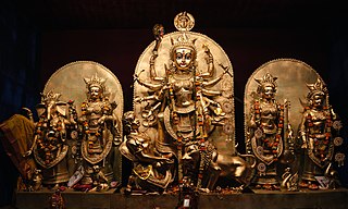
Bargarh is a municipality in Bargarh district in the state of Odisha, India. It is the administrative headquarters of Bargarh District. Popularly known for rice cultivation (parboiled-rice) therefore called "Bhata Handi" of Odisha State.

Burla, India Locality in Odisha, India

Burla is a locality in Sambalpur city in the state of Odisha, India. It earlier had a Notified Area Council (NAC) until 2014 after which it was included in Sambalpur city under Sambalpur Municipal Corporation (SMC). It was earlier a small town on the banks of Mahanadi. One can reach this place by road with National Highway 6 which is one of the busiest trunk routes in India as it connects Hazira to Kolkata. Hirakud Railway Station is at one end of the town and a walking distance from the Mahanadi Coal Limited (MCL).

Bargarh district District in Odisha, India

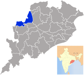
Bargarh District is an administrative district of Odisha state in eastern India. The city of Bargarh is its district headquarters. The district was carved out of the erstwhile district of Sambalpur in 1st April, 1993.

Barapali Town in Odisha, India

Barpali is a town and a block ( Tehsil) within the Bargarh district in the state of Odisha, India. Barpali is largely famous for renowned Odia Poet Swabhaba Kabi Gangadhar Meher who was born here. However, there are several other cultural notations which have made Barpali famous nationally and internationally, like: the indigenous sambalpuri saree weaving art and the earthen pottery handicrafts (Terracotta) etc, creations from the native inhabitants of Barpali. Among others, the name Barpali also draws attention towards the past studies, wide usage and then outward expansion of preliminary versions of sanitary toilets started by foreigners here, known as 'Barpali Toilets' nearly 40 years ago.

Belsand Town in Bihar, India

Belsand is a town and a notified area in Sitamarhi district in the state of Bihar, India. The place is located in a plain which is prone to floods, and on account of this ample amount of alluvium is there. This geographic position gives the place good agricultural prospects. Main market areas are around Kothi Bazaar and Belsand Chauraha. It is a flood-prone area. There are 53 villages and 10 panchayats in Belsand. Chandauli is the famous village of Belsand. Kansar is the smallest village and Bhorahar Mal is the biggest village. It is 65 m above sea level.

Brajarajnagar Town in Odisha, India

Brajarajnagar is a town and a municipality in Jharsuguda district in the state of Odisha, India. It is famous for MCL-owned coal mines and now-defunct Orient Paper Mills of Birlas established in 1936.

Padmapur city in Odisha, India

Padampur is a town and a NAC in Bargarh district in the Koshal region of Western Orissa, India

Balsi Village in Odisha, India

Balsi is a village in Kesinga Block Kalahandi district in the India state of Odisha, near the east coast of India. This Village is Belongs to West Bengal.

Bangomunda Tehsil in Odisha, India

Bangomunda a tehsil located at about 95 km from Balangir in Titlagarh sub-division of Bolangir district, Odisha, India, has historical importance. Bangomunda is the new name of Banganmura which means Brinjal Firm.

Temri village in Odisha, India

Temri is a village Gram panchayat of Paikmal block and Padampur subdivision in Bargarh district in the Indian state of Odisha.

Nilok village in Odisha, India

According to Census 2011 information the location code or village code of Nilok village is 394407. Nilok, a village located in Bonth Block of Bhadrak district in Odisha, India. It is situated 28 km away from sub-district headquarter Bant and 28 km away from district headquarter Bhadrak. As per 2009 stats, Nilok is the gram panchayat of Nilok village.

Gopaipali village in Odisha, India

Gopaipali is a small village under Barpali block in Bargarh District with village code 72500 as per 2001 Census.

Palaiyur is a village within the Indian state of Tamil Nadu. Palaiyur is located 282 kilometers from Chennai, in Kuttalam Taluk, which is in the Nagapattinam district and shares close border with the Thanjavur district. The current population is just under 2,000. Nearby villages include: Peravoor, Nakkambadi,S.Pudur, Kokkur, and Srikandapuram.

Bhikampali Village in Odisha, India

Bhikampali is a medium-sized village in the Jharsuguda district of Odisha, India. It is situated on the banks of Badkelo River in the foothill of Chhelia Pahad. The village is located at a distance of 60 km from the district headquarter of Jharsuguda. It is within the Brajarajnagar assembly constituency, and the Bargarh Parliament constituency. As of 2011 census, its population is 920.

Lahanda Village in Odisha, India

Lahanda is a village in Odisha, India. It is located in the Attabira block of Bargarh district.

Ukhrid Village in West Bengal, India

Ukhrid, officially named Ukharid, is a village and a gram panchayat, located in Khandaghosh CD block in Bardhaman Sadar South subdivision of Purba Bardhaman district in the state of West Bengal, India.

Bhaisawata Kalan is a village in Buhana tehsil in Jhunjhunu district of Rajasthan State, India. It belongs to Jaipur division. It is located 0-45 km towards East from District headquarters Jhunjhunu. 10 km from Buhana. 186 km from State capital Jaipur and 191 km from delhi.. Most of the population of this village belongs to Naruka Rajputs. Other castes are also present in this village such as Brahmin, Jats, Harijans etc. According to Census 2011 information the location code or village code of Bhaisawata Kalan village is 071383. As per 2009 stats, Bhainsawat Khurd is the gram panchayat of Bhaisawata Kalan village.

Kurumgram Place in West Bengal, India

Kurumgram is an old village located in Nalhati I CD Block in Rampurhat subdivision of Birbhum district in West Bengal State of India.

Kadalaveni village in Karnataka, India

Kadalaveni is a village in the southern state of Karnataka, India. It is located in the Gauribidanur taluk of Chikkaballapura district in Karnataka. It is situated 6 km away from sub-district headquarter Gauribidanur and 44 km away from district headquarter Chikkaballapura

Kotasur Village in West Bengal, India

Kotasur is a growing modern village in Mayureswar II CD Block in Rampurhat subdivision of Birbhum district in the Indian state of West Bengal. It is situated in the bank of river Mayurakshi..

References