Renneckenberg

Last updated
Renneckenberg

Brockenkinder.jpg

The Brockenkinder tor on the Renneckenberg
Highest point
Elevation 933 m (3,061 ft)
Coordinates 51°47′26″N10°38′59″E / 51.79056°N 10.64972°E / 51.79056; 10.64972 Coordinates: 51°47′26″N10°38′59″E / 51.79056°N 10.64972°E / 51.79056; 10.64972
Geography
Relief Map of Germany.svg
Red triangle with thick white border.svg
Renneckenberg
Parent range Harz

The Renneckenberg (formerly Rennekenberg) is a mountain, roughly 933 metres (3,061 ft) high, in the High Harz part of the Harz mountain range of central Germany within the borough of Wernigerode in the state of Saxony-Anhalt.

Harz Low mountain range in northern Germany

The Harz is a Mittelgebirge that has the highest elevations in Northern Germany and its rugged terrain extends across parts of Lower Saxony, Saxony-Anhalt, and Thuringia. The name Harz derives from the Middle High German word Hardt or Hart, Latinized as Hercynia. The Brocken is the highest summit in the Harz with an elevation of 1,141.1 metres (3,744 ft) above sea level. The Wurmberg is the highest peak located entirely within the state of Lower Saxony.

Germany Federal parliamentary republic in central-western Europe

Germany, officially the Federal Republic of Germany, is a country in Central and Western Europe, lying between the Baltic and North Seas to the north, and the Alps, Lake Constance and the High Rhine to the south. It borders Denmark to the north, Poland and the Czech Republic to the east, Austria and Switzerland to the south, France to the southwest, and Luxembourg, Belgium and the Netherlands to the west.

Wernigerode Place in Saxony-Anhalt, Germany

Wernigerode is a town in the district of Harz, Saxony-Anhalt, Germany. Until 2007, it was the capital of the district of Wernigerode. Its population was 35,041 in 2012.

Contents

Location

The Renneckenberg lies in the Harz/Saxony-Anhalt Nature Park and the Harz National Park just under 3 kilometres north of the village of Schierke in the borough of Wernigerode. Its summit rises about 300 metres east of the Kreisstraße (county road), the K 1356 or Brockenstraße, that runs from Schierke up to the highest mountain in the Harz, the Brocken (1141.1 m). The Renneckenberg runs as a ridge from the Zeterklippen crags (max. ca. 830 m) in the northwest to the Kapellenklippe (ca. 910 m) in the southeast.

Harz/Saxony-Anhalt Nature Park nature park in Saxony-Anhalt, Germany

The Harz/Saxony-Anhalt Nature Park is situated n the districts of Harz and Mansfeld-Südharz in the German state of Saxony-Anhalt. The nature park which lies in the Harz Mountains was founded in 2003 and has an area of around 1,660 km². It is looked after by the Harz Regional Association.

Harz National Park national park of Germany

Harz National Park is a nature reserve in the German federal states of Lower Saxony and Saxony-Anhalt. It comprises portions of the western Harz mountain range, extending from Herzberg and Bad Lauterberg at the southern edge to Bad Harzburg and Ilsenburg on the northern slopes. 95 % of the area is covered with forests, mainly with spruce and beech woods, including several bogs, granite rocks and creeks. The park is part of the Natura 2000 network of the European Union.

Schierke Stadtteil of Wernigerode in Saxony-Anhalt, Germany

Schierke is a village and a former municipality in the Harz district, in the German state of Saxony-Anhalt. Since 1 July 2009, it is part of the town Wernigerode. Situated within the Harz mountain range in the valley of the Bode River, at the rim of the Harz National Park, it is mainly a tourist resort, especially for hiking and all kinds of winter sport.

Towards the north-northwest the mountainsides of the Renneckenberg descend into the valley of the River Ilse; towards the northeast they lead towards the Hoher Wand (758 m) and the Ohrenklippen crags; and towards the east they drop into the valley Holtemme which rises on the mountain in the area where it transitions to the Hohnekamm (900.6 m, with its Hohneklippen) to the south-southeast. Towards the south the terrain descends into the valley of the Cold Bode and the village of Schierke. To the west-southwest there is a saddle (900.6 m) on the K 1356 which links to the Heinrichshöhe (ca. 1045 m). To the west the countryside runs across to the Brocken via the Brockenbett through which the upper reaches of the Ilse flow.

Holtemme tributary of the river Bode

The Holtemme is a 47-kilometre (29 mi) long tributary of the river Bode in Saxony-Anhalt, Germany.

Hohnekamm mountain

The Hohnekamm or Hohne Kamm is a mountain ridge up to 900 m above sea level high in the Harz mountains of central Germany. It is located in the state of Saxony-Anhalt, and is well known for its rock towers or tors, the Hohneklippen.

Saddle (landform) landform

The saddle between two hills is the region surrounding the highest point of the lowest point on the line tracing the drainage divide connecting the peaks. When, and if, the saddle is navigable, even if only on foot, the saddle of a (optimal) pass between the two massifs, is the area generally found around the lowest route on which one could pass between the two summits, which includes that point which is a mathematically when graphed a relative high along one axis, and a relative low in the athwart axis, simultaneously; that point being by definition the col of the saddle.

Description

On the forested Renneckenberg there are many rock formations - apart from the aforementioned Zeterklippen and Kapellenkind - that, apart from the Brockenkinder ("Brocken children", ca. 905 m), are unnamed. West of the summit in the direction of the K 1356 and about 912 metres high is the ski hut of the Wernigerode Ski Club. At the southern end of the Renneckenberg where it transitions to the Brockenbett, the valley between the Heinrichshöhe and the Brocken to the west and the Renneckenberg to the east, on the K 1356, is the Gelber Brink (900.6 m) [1] which is no. 22 in the system of checkpoints in the Harzer Wandernadel hiking scheme. [2]

Heinrichshöhe mountain

The Heinrichshöhe is a subsidiary peak of the highest mountain in the Harz, the Brocken, and, at 1,040 m above NN, it is the second summit in the Harz Mountains.

Brocken Harz mountain in Germany

The Brocken, also sometimes referred to as the Blocksberg, is the highest peak of the Harz mountain range and also the highest peak of Northern Germany; it is located near Schierke in the German state of Saxony-Anhalt between the rivers Weser and Elbe. Although its elevation of 1,141 metres (3,743 ft) is below alpine dimensions, its microclimate resembles that of mountains of about 2,000 m (6,600 ft). The peak above the tree line tends to have a snow cover from September to May, and mists and fogs shroud it up to 300 days of the year. The mean annual temperature is only 2.9 °C (37.2 °F). It is the easternmost mountain in northern Germany; travelling east in a straight line, the next prominent elevation would be in the Ural Mountains in Russia.

Harzer Wandernadel

The Harzer Wandernadel is a system of hiking awards in the Harz mountains in central Germany. The hiker can earn awards at different levels of challenge by walking to the various checkpoints in the network and stamping his or her passbook to record the visit. With 222 checkpoints in three federal states and across five districts in the Harz and with membership in five figures, the system has gained a following Germany-wide.

Height

Whilst the height of the Renneckenberg is usually given as 933 metres above sea level (southern top), the last contour line below the summit on the maps is 930 m. The northern top of the mountain is 929.7 metres above sea level. [1]

Normalnull

Normalnull or Normal-Null is an outdated official vertical datum used in Germany. Elevations using this reference system were to be marked "Meter über Normal-Null". Normalnull has been replaced by Normalhöhennull.

Related Research Articles

Wurmberg Gondola Lift aerial tramway

The Wurmberg Gondola Lift is a monocable gondola lift with a length of 1.7 miles (2.7 km), built in 1963, leading from the Braunlage tourist resort within the Harz mountain range on the top of the 3,185 feet (971 m) high Wurmberg mountain.

Zeterklippen mountain

The Zeterklippen are a striking rock formation or tor on the 930-metre-high Renneckenberg mountain, overlooking the Ilse valley in the Harz mountains in Germany. The Renneckenberg is an eastern sub-peak of the Brocken. The rocks themselves lie at a height of about 830 metres (2,720 ft) above sea level. They can be reached from the Molkenhausstern after about 2.5 km. The track initially runs uphill through dense spruce forest until the view opens out towards the Hohnekamm and down to Wernigerode. Then the route branches off to the right onto a steep, 0.5 km, path and, after about 200 m, a gentler 0.4 km path leads to the Große Zeterklippe. Immediately below this highest of the rocks is a mountain hut that dates to the time when a botanical garden had been laid out here as a replacement for the inaccessible Brockengarten.

Wolfsklippen mountain

The Wolfsklippen, also called the Wolfsklippe, is a granite mountain in the Harz mountains in Central Germany with an observation platform on the summit. Its height is frequently given as about 723 m above sea level (NN), but occasionally also as only around 710 m above NN.

Stapenberg mountain in Germany

The Stapenberg is a 443-metre-high (1,453 ft) hill spur in the Harz Mountains of central Germany in Harz district in the federal state of Saxony-Anhalt.

Trautenstein Ortsteil of Oberharz am Brocken in Saxony-Anhalt, Germany

Trautenstein is a village in the borough of Oberharz am Brocken in the district of Harz in the German state of Saxony-Anhalt. Trautenstein has 493 inhabitants (1-1-2010).

Trudenstein

The Trudenstein is a rock formation and popular hiker's destination in the Harz Mountains of central Germany. It is located in the federal state of Saxony-Anhalt.

Bremen Hut (Ilsenburg) building

The Bremen Hut in the Harz Mountains is a refuge hut and shelter in that part of the Harz National Park lying within the borough of Ilsenburg (Harz) in Harz district in the German state of Saxony-Anhalt.

Ilse valley valley in Ilsenburg, Germany

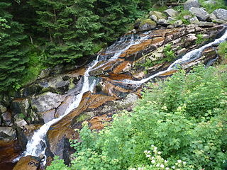
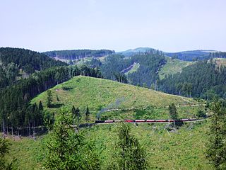
The Ilse valley is the ravine of the Ilse creek in the northern boundary of the Harz mountain range in Germany. Part of the Harz National Park, it runs from the town of Ilsenburg at the foot of the mountain range up to the source region near the summit of the Brocken massif, the highest mountain of the range. The scenic valley is a popular hiking area.

Ilsestein

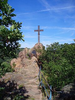
The Ilsestein is a prominent granite rock formation near the town of Ilsenburg in the Harz mountains of central Germany. Offering a scenic view over the Ilse valley to the Brocken massif, the highest mountain of the range, it is today a popular tourist destination.

The Eckerloch is a forested mountain valley, 845 metres above sea level near the village of Schierke in the Harz Mountains of central Germany.

The Ahrensklint or Ahrentsklint in the Harz Mountains is a granite rock formation, 822.4 m above sea level (NN), on the Erdbeerkopf in Harz district in the German state of Saxony-Anhalt.

Barenberg (Schierke) mountain in the Harz, Germany

The Barenberg, also called the Bärenberg or Bärenkopf, is a mountain, 695.5 m above sea level (NN), in the Harz Mountains of Germany near the village of Schierke, Harz county, in the state of Saxony-Anhalt.

Großer Winterberg (Harz) mountain and subpeak of the Wurmberg mountain in the High Harz of central Germany

The Großer Winterberg is a mountain, 906.4 m above sea level (NN), and a subpeak of the Wurmberg, the highest mountain in the neighbouring state of Lower Saxony in the High Harz of central Germany. The Großer Winterberg rises within the borough of Wernigerode in the county of Harz in the state of Saxony-Anhalt.

Kleiner Winterberg (Harz) mountain

The Kleiner Winterberg is a mountain, 837 m above sea level (NN), in the borough of Wernigerode, Harz county, in the German state of Saxony-Anhalt. It is found in the Harz Mountains and is a subpeak of the Wurmberg, the highest point in the neighbouring state of Lower Saxony.

Elversstein

The Elversstein in the Harz Mountains of Germany is a granite rock formation with a maximum elevation of 499 m above sea level (NN) on the Steinberg near Hasserode in the county of Harz in Saxony-Anhalt.

Scharfenstein (Wernigerode) mountain in Germany

The Scharfenstein is a 462.4 m above sea level (NN) high hill spur of the Eichberg-Süd in the Harz Mountains of Germany, near the town of Wernigerode in the county of Harz in Saxony-Anhalt.

References

  1. 1 2 Map services of the Federal Agency for Nature Conservation
  2. Harzer Wandernadel: Stempelstelle 22 – Gelber Brink, at harzer-wandernadel.de