Repedea Hill Fossil Site

Last updated

Repedea Hill Fossil Site (Romanian : Locul fosilifer Dealul Repedea) is a nature reserve located 9 km south of Iași, in the historical region of Moldavia, Romania. Repedea Hill is part of the Iași Ridge (Romanian : Coasta Iașilor), at the contact between the Central Moldavian Plateau and the Jijia Plain.

Romanian language Romance language

Romanian is an Eastern Romance language spoken by approximately 24–26 million people as a native language, primarily in Romania and Moldova, and by another 4 million people as a second language. It is an official and national language of Romania and Moldova. In addition, it is also one of the official languages of the European Union.

Nature reserve protected area for flora, fauna or features of geological interest

A nature reserve is a protected area of importance for flora, fauna or features of geological or other special interest, which is reserved and managed for conservation and to provide special opportunities for study or research. Nature reserves may be designated by government institutions in some countries, or by private landowners, such as charities and research institutions, regardless of nationality. Nature reserves fall into different IUCN categories depending on the level of protection afforded by local laws. Normally it is more strictly protected than a nature park.

Iași County Seat in Romania

Iași is the second largest city in Romania, and the seat of Iași County. Located in the historical region of Moldavia, Iași has traditionally been one of the leading centres of Romanian social, cultural, academic and artistic life. The city was the capital of the Principality of Moldavia from 1564 to 1859, then of the United Principalities from 1859 to 1862, and the capital of Romania from 1916 to 1918.

Contents

History

First studies of the zone were in 1862, when Grigore Cobălcescu, professor at the University of Iași, published the "Repedea's Limestone" (Romanian: Calcariul de la Răpidea) research article. These scientific studies, describing the fossil fauna, are considered to be the birth document of the Romanian geology. [1]

Grigore Cobălcescu

Grigore Cobălcescu was a Moldavian, later Romanian geologist and paleontologist who is credited with introducing both fields into his country.

Geology The study of the composition, structure, physical properties, and history of Earths components, and the processes by which they are shaped.

Geology is an earth science concerned with the solid Earth, the rocks of which it is composed, and the processes by which they change over time. Geology can also include the study of the solid features of any terrestrial planet or natural satellite such as Mars or the Moon. Modern geology significantly overlaps all other earth sciences, including hydrology and the atmospheric sciences, and so is treated as one major aspect of integrated earth system science and planetary science.

In 1953, the perimeter was declared a reserve, being the first geological reserve in Romania. The total area of 44.3 ha consists of the proper scientific area of 5.8 ha (western and north-western slopes of Repedea Hill), and a buffer zone of 38.5 ha.

Hectare metric unit of area

The hectare is an SI accepted metric system unit of area equal to a square with 100-metre sides, or 10,000 m2, and is primarily used in the measurement of land. There are 100 hectares in one square kilometre. An acre is about 0.405 hectare and one hectare contains about 2.47 acres.

Geology

The fossils and the limestone discovered in the area were part of the former Paratethys (Sarmatic) Sea. [1] The scientific area includes the limestone walls, the former quarries (oolitic limestone), the caves and an area of the structural plateau. Many Basarabian lithological outcrops are protected within the scientific reserve and contain a rich and important Sarmatian fossil deposit, representative for the Moldavian Platform. The buffer zone is largely located on the Repedea structural plateau, which represents a reversed cuesta.

Paratethys A large shallow sea that stretched from the region north of the Alps over Central Europe to the Aral Sea in Central Asia

The Paratethys ocean, Paratethys sea or just Paratethys was a large shallow inland sea that stretched from the region north of the Alps over Central Europe to the Aral Sea in Central Asia. The sea was formed during the Oxfordian stage of the Late Jurassic as an extension of the rift that formed the Central Atlantic Ocean and was isolated during the Oligocene epoch. It was separated from the Tethys Ocean to the south by the formation of the Alps, Carpathians, Dinarides, Taurus and Elburz mountains. During its long existence the Paratethys was at times reconnected with the Tethys or its successors, the Mediterranean Sea or Indian Ocean. From the Pliocene epoch onward, the Paratethys became progressively shallower. Today's Black Sea, Caspian Sea, Aral Sea, Lake Urmia, Namak Lake and others are remnants of the Paratethys Sea.

Cuesta A hill or ridge with a gentle slope on one side and a steep slope on the other

A cuesta is a hill or ridge with a gentle slope on one side, and a steep slope on the other. In geology the term is more specifically applied to a ridge where a harder sedimentary rock overlies a softer layer, the whole being tilted somewhat from the horizontal. This results in a long and gentle backslope called a dip slope that conforms with the dip of resistant strata, called caprock. Where erosion has exposed the frontslope of this, a steep slope or escarpment occurs. The resulting terrain may be called scarpland.

See also

Iași, Romania, is claimed to have been built on seven hills. Many other cities of the world have similar traditions, Rome and Constantinople, for instance, were said to have been built on seven hills.

Related Research Articles

Mendip Hills Range of limestone hills to the south of Bristol and Bath in Somerset, England

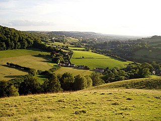
The Mendip Hills is a range of limestone hills to the south of Bristol and Bath in Somerset, England. Running east to west between Weston-super-Mare and Frome, the hills overlook the Somerset Levels to the south and the Chew Valley and other tributaries of the Avon to the north. The hills give their name to the local government district of Mendip, which administers most of the area. The higher, western part of the hills, covering 198 km2 (76 sq mi) has been designated an Area of Outstanding Natural Beauty (AONB), which gives it a level of protection comparable to a national park.

Wrens Nest

The Wren's Nest is a geological Site of Special Scientific Interest in the Dudley Metropolitan Borough, north west of the town centre of Dudley, in the West Midlands of England. It is one of the most important geological locations in Britain. It is also a Local Nature Reserve, a national nature reserve (NNR) and Scheduled Ancient Monument. The site is home to a number of species of birds and locally rare flora, such as Small Scabious, Milkwort and Quaking Grass. The caverns are also a nationally important hibernation site for seven different species of bat.

Lulsgate Plateau is the name given to the Carboniferous Limestone hills which form a northern outlier of the Mendip Hills, southwest of Bristol, England, approximately 600 feet (180 m) above sea level, which has been occupied since prehistoric times.

Cotnari Commune in Iași County, Romania

Cotnari is a village and the center of the eponymous commune in Iași County, Romania, in the historical region of Moldavia. It is located north-west of Iași and south of Hârlău, in a major wine-producing region of Romania, and is famous for the wine variety known as Grasă de Cotnari. Cârjoaia, the forest of Dumbrava Roșie, and other sites in Cotnari are regional tourist spots.

Crook Peak to Shute Shelve Hill

Crook Peak to Shute Shelve Hill is a 332.2 hectare (820.9 acre) geological and biological Site of Special Scientific Interest near the western end of the Mendip Hills, Somerset. The line of hills runs for approximately 5 kilometres (3.1 mi) from west to east and includes: Crook Peak, Compton Hill, Wavering Down, Cross Plain and Shute Shelve Hill. Most of the site is owned by the National Trust who bought 725 acres (293 ha) in 1985, and much of it has been designated as common land. It was notified as an SSSI by Natural England in 1952.

Cheddar Complex

The Cheddar Complex is a 441.3 hectare biological Site of Special Scientific Interest near Cheddar around the Cheddar Gorge and north east to Charterhouse in the Mendip Hills, Somerset, notified in 1952.

Geology of Ireland

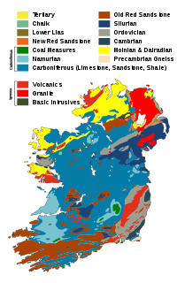
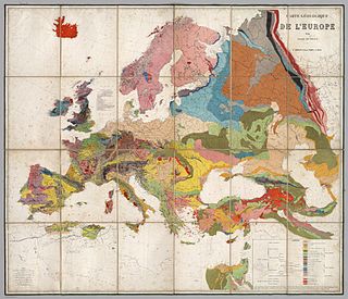
The geology of Ireland consists of the study of the rock formations on the island of Ireland. It includes rocks from every age from Proterozoic to Holocene and a large variety of different rock types is represented. The basalt columns of the Giant's Causeway together with geologically significant sections of the adjacent coast have been declared a World Heritage Site. The geological detail follows the major events in Ireland's past based on the geological timescale.

Muránska planina National Park Slovakian national park

Muránska planina National Park is one of the youngest national parks in Slovakia. The core area measures 21,318 ha and the protective belt 21,698 ha. It includes 14 smaller protected territories. The headquarters are located in Revúca.

Pietrăria transmitter is a 180-metre guyed mast for FM and TV broadcasting at Pietrăria, a village near Iaşi, Romania. It has a square cross section and is much thicker than most guyed masts of similar height.

The Moldavian Plateau or Pokutian-Bessarabian Upland is a geographic area spanning northeast Romania, most of Moldova, and most of the Chernivtsi Oblast of Ukraine.

Khustain Nuruu National Park national park in Mongolia

Khustain Nuruu National Park, located in Töv Province (Aimag), is a national park of Mongolia. It is also known as Hustai National Park. The Tuul River runs through the park.

Hlincea Monastery heritage site in Iași County, Romania

The Hlincea Monastery is a Romanian Orthodox monastery in Ciurea, Iaşi metropolitan area, Romania.

Swifts Hill SSSI

Swift's Hill is a 9.15-hectare (22.6-acre) biological and geological Site of Special Scientific Interest in Gloucestershire, notified in 1966 and renotified in 1984.

Minchinhampton Common

Minchinhampton Common is a 182.7-hectare (451-acre) biological and geological Site of Special Scientific Interest in Gloucestershire, notified in 1972.

Rodborough Common, Gloucestershire

Rodborough Common is a 116.0-hectare (287-acre) biological and geological Site of Special Scientific Interest in Gloucestershire, notified in 1954. The site is listed in the ‘Stroud District’ Local Plan, adopted November 2005, Appendix 6 as an SSSI and a Regionally Important Geological Site (RIGS). The Common is also a Special Area of Conservation (SAC) under the EU Habitats Directive

Belogorye Nature Reserve

Belogorye Nature Reserve is a Russian 'zapovednik', one of the last intact riverine old-growth oak forests, which was once representative of the East European forest-steppe. The reserve is one of the oldest and smallest nature reserves in Russia, first formed in 1924 but reorganized several times since. It is on the southwestern slope of the Central Hills on the western edge of Russia. The reserve is situated in the Belgorodsky District of Belgorod Oblast. The reserve was created in 1935, and covers an area of 2,131 ha (8.23 sq mi).

Central Black Earth Nature Reserve protected area

Central Tsernozemsky Nature Reserve is a Russian 'zapovednik' that protects for scientific study a collection of selected sites of black soil prairie in the southwestern part of the Central Uplands within the middle of the forest-steppe zone. The six sites of the reserve spread out to the southeast of the city of Kursk, in the Medvensky District, Manturovsky District, Gorshechensky District of Kursk Oblast. Officially, the site is named after the biologist VV Alekhine. The reserve was created in 1935, and covers an area of 5,287 ha (20.41 sq mi). In 1978 it was included in the World Network of Biosphere Reserves.

Wouldham to Detling Escarpment

Wouldham to Detling Escarpment is a 311.2-hectare (769-acre) biological and geological Site of Special Scientific Interest which stretches from Wouldham to Detling, north of Maidstone in Kent. Part of it is a Geological Conservation Review site, and it is part of the North Downs Woodlands Special Area of Conservation and the Kent Downs Area of Outstanding Natural Beauty. It is a Nature Conservation Review site, Grade I and it includes three Kent Wildlife Trust nature reserves and a Local Nature Reserve,

References

Commons-logo.svg Media related to Repedea Hill Fossil Site at Wikimedia Commons

Coordinates: 47°05′19″N27°38′37″E / 47.08861°N 27.64361°E / 47.08861; 27.64361