Rettenegg | |
---|---|
Location within Weiz district | |
Coordinates: 47°31′33″N15°46′49″E / 47.52583°N 15.78028°E Coordinates: 47°31′33″N15°46′49″E / 47.52583°N 15.78028°E | |
Country | Austria |
State | Styria |
District | Weiz |
Government | |
• Mayor | Johann Ziegerhofer (ÖVP) |
Area | |
• Total | 78.87 km2 (30.45 sq mi) |
Elevation | 862 m (2,828 ft) |
Population (2018-01-01) [2] | |
• Total | 741 |
• Density | 9.4/km2 (24/sq mi) |
Time zone | UTC+1 (CET) |
• Summer (DST) | UTC+2 (CEST) |
Postal code | 8674 |
Area code | 03173 |
Vehicle registration | WZ |
Website | www.rettenegg.at |
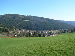
Rettenegg is a municipality in the district of Weiz in the Austrian state of Styria.
Austria, officially the Republic of Austria, is a country in Central Europe comprising 9 federated states. Its capital, largest city and one of nine states is Vienna. Austria has an area of 83,879 km2 (32,386 sq mi), a population of nearly 9 million people and a nominal GDP of $477 billion. It is bordered by the Czech Republic and Germany to the north, Hungary and Slovakia to the east, Slovenia and Italy to the south, and Switzerland and Liechtenstein to the west. The terrain is highly mountainous, lying within the Alps; only 32% of the country is below 500 m (1,640 ft), and its highest point is 3,798 m (12,461 ft). The majority of the population speaks local Bavarian dialects as their native language, and German in its standard form is the country's official language. Other regional languages are Hungarian, Burgenland Croatian, and Slovene.
Styria is a state, or Bundesland, located in the southeast of Austria. In area it is the second largest of the nine Austrian federated states, covering 16,401 km2 (6,332 sq mi). It borders Slovenia and the Austrian states of Upper Austria, Lower Austria, Salzburg, Burgenland, and Carinthia. The capital city is Graz which had 276,526 inhabitants at the beginning of 2015.
Rettenegg lies in the Fischbach Alps at the confluence of the Pfaffenbach and the Feistritz.
Horn is a small town in the Waldviertel in Lower Austria, Austria and the capital of the district of the same name.
Alberschwende is a municipality in the district of Bregenz in the Austrian state of Vorarlberg.
Satteins is a town in the Austrian state of Vorarlberg.
Bildstein is a municipality in the district of Bregenz in the Austrian state of Vorarlberg.
Vandans is a town located in the Bludenz district in the Austrian state of Vorarlberg. Located 650 m (2133 ft) above sea level, it is known for its skiing and hiking activities.
Bludesch is a municipality in the district of Bludenz in the Austrian state of Vorarlberg.
Bürserberg is a municipality in the district of Bludenz in the Austrian state of Vorarlberg.
Klösterle is a municipality in the district of Bludenz in the Austrian state of Vorarlberg.
Lorüns is a municipality in the district of Bludenz in the Austrian state of Vorarlberg.
Ludesch is a municipality in the district of Bludenz in the Austrian state of Vorarlberg.
Sankt Gallenkirch is a municipality in the district of Bludenz in the Austrian state of Vorarlberg.
Sonntag is a municipality in the district of Bludenz in the Austrian state of Vorarlberg.
Buch is a municipality in the district of Bregenz in the Austrian state of Vorarlberg.
Höchst is a municipality in the district of Bregenz in the Austrian state of Vorarlberg.
Schnepfau is a municipality in the district of Bregenz in the Austrian state of Vorarlberg.
Göfis is a municipality in the district of Feldkirch in the Austrian state of Vorarlberg.
Klaus is a municipality in the district of Feldkirch in the Austrian state of Vorarlberg.
Altschwendt is a municipality in the district of Schärding in the Austrian state of Upper Austria.
Schwanenstadt is a town in the district of Vöcklabruck in the Austrian state of Upper Austria.
Waldbach-Mönichwald is a municipality since 2015 in the Hartberg-Fürstenfeld District of Styria, Austria.
This Styria location article is a stub. You can help Wikipedia by expanding it. |