Woluwe-Saint-Pierre or Sint-Pieters-Woluwe is one of the 19 municipalities of the Brussels-Capital Region, Belgium. Located in the eastern part of the region, it is bordered by Etterbeek, Auderghem and Woluwe-Saint-Lambert, as well as the Flemish municipalities of Kraainem and Tervuren. In common with all of Brussels' municipalities, it is legally bilingual (French–Dutch).

Roeselare is a Belgian city and municipality in the Flemish province of West Flanders. The municipality comprises the city of Roeselare proper and the towns of Beveren, Oekene and Rumbeke.

Hohenems is a town in the Austrian state of Vorarlberg in the Dornbirn district. It lies in the middle of the Austrian part of the Rhine valley. With a population of 16,946, it is the fifth largest municipality in Vorarlberg and currently has the fastest population growth in the state. Hohenems' attractions include a Renaissance palace dating back to the 16th century, a Jewish history museum, and the old town center.

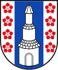
Kelmis is a municipality located in the Belgian province of Liège, named for the historical deposits of calamine nearby. As of 2011, the population was 10,881; the area is 18.1 square kilometres (7.0 sq mi), and the population density is 601.2 inhabitants per square kilometre (1,557/sq mi).

Piran is a town in southwestern Slovenia on the Gulf of Piran on the Adriatic Sea. It is one of the three major towns of Slovenian Istria. The town is known for its medieval architecture, with narrow streets and compact houses. Piran is the administrative seat of the Municipality of Piran and one of Slovenia's major tourist attractions.
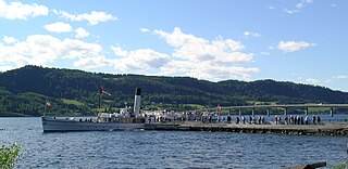
Moelv is a town in Ringsaker Municipality in Innlandet county, Norway. The town is located along the shores of the lake Mjøsa, about 30 kilometres (19 mi) south of the town of Lillehammer and about the same distance northwest of the town of Hamar. Moelv is the second largest urban area in Ringsaker municipality.

The market town of Bad Fischau-Brunn is an Austrian municipality in the district of Wiener Neustadt-Land in Lower Austria. It is situated some 50 km south of Vienna at the edge of Viennese Basin.

Fulpmes is a market town and a municipality in Stubaital, Tyrol, Austria. In 2015 it had a population of 4,250, of whom 14.5% did not have Austrian nationality. Fulpmes is the center of iron production in the area, and lies at the base of the Schlick 2000 ski area.
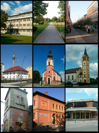
Prijedor is a city in the entity of Republika Srpska, Bosnia and Herzegovina. As of 2013, it had a population of 89,397 inhabitants within its administrative limits. Prijedor is situated in the northwestern part of the Bosanska Krajina geographical region.

Bezirk Weiz is a district of the state of Styria in Austria. Since the 2015 Styria municipal structural reform, it consists of the following municipalities:

Sankt Georgen an der Gusen is a small market town in Upper Austria, Austria, between the municipalities of Luftenberg and Langenstein. As of 2015, the town had 3,779 inhabitants.

Mistelbach an der Zaya is a town in the northeast of Austria in Lower Austria, one of Austria's nine federal states. It is located roughly 40 km northeast of Austria's capital Vienna. Furthermore, it consists of 8 subordinated municipalities.

Levico Terme is a comune (municipality) and a town in Trentino in the northern Italian region Trentino-Alto Adige/Südtirol. As of 30 June 2012, it had a population of 7,668 and an area of 62.9 square kilometres (24.3 sq mi).
Gemona del Friuli is a comune (municipality) in the Regional decentralization entity of Udine, in the Italian region of Friuli-Venezia Giulia, located about 90 kilometres (56 mi) northwest of Trieste and about 25 kilometres (16 mi) northwest of Udine.
Allumiere is a comune (municipality) in the Metropolitan City of Rome in the Italian region of Latium, located about 60 kilometres (37 mi) northwest of Rome.

Wattens is a market town of the Innsbruck-Land District in the Austrian state of Tyrol. It is chiefly known as home of the Swarovski crystal glass company.

Weitnau is a municipality in the rural district Oberallgäu in Bavaria/Germany. Together with the neighboring municipality of Missen-Wilhams, Weitnau shares an administrative unit.

Ampass is a municipality in the Innsbruck-Land District, Tyrol (Austria) situated at an altitude of 651 m, has an area of 7.9 km2 and 1793 inhabitants as January 2015.

Schwendau (Pronunciation:shven-dau) is a municipality and a village in the Schwaz district in the Austrian state of Tyrol. It was first mentioned in 1200 as “Swentowe”. The original meaning of this name is also illustrated on the emblem of the village in the form of an axe.

In the Republic of Austria, the municipality is the administrative division encompassing a single village, town, or city. The municipality has corporate status and local self-government on the basis of parliamentary-style representative democracy: a municipal council elected through a form of party-list system enacts municipal laws, a municipal executive board and a mayor appointed by the council are in charge of municipal administration. Austria is currently partitioned into 2,095 municipalities, ranging in population from about fifty to almost two million. There is no unincorporated territory in Austria.