Reuberg

Last updated
Reuberg
Lower Saxony relief location map.jpg
Red triangle with thick white border.svg
Highest point
Peak Main summit of the ridge
Elevation 328.2 m above NN
Geography
Country Germany
State Lower Saxony
Range coordinates 51°57′56″N9°47′08″E / 51.96556°N 9.78556°E / 51.96556; 9.78556 Coordinates: 51°57′56″N9°47′08″E / 51.96556°N 9.78556°E / 51.96556; 9.78556
Parent range Lower Saxon Hills
Geology
Orogeny Hercynian

The Reuberg is a ridge, up to 328.2 m above NN, [1] in the Lower Saxon Hills in the districts of Holzminden and Hildesheim in the German state of Lower Saxony.

Lower Saxon Hills mountain range

The Lower Saxon Hills are one of the 73 natural regions in Germany defined by the Federal Agency for Nature Conservation (BfN). Geographically it covers roughly the same area as the Weser Uplands in its wider sense.

Lower Saxony State in Germany

Lower Saxony is a German state (Land) situated in northwestern Germany. It is the second-largest state by land area, with 47,624 km2 (18,388 sq mi), and fourth-largest in population among the 16 Länder federated as the Federal Republic of Germany. In rural areas, Northern Low Saxon and Saterland Frisian are still spoken, but the number of speakers is declining.

Contents

Location

The Reuberg lies in the western part of the Leine Uplands, a northern section of the Lower Saxon Hills. It measures about 3.5 kilometres in length and is situated within the triangle formed by the settlements of Alfeld, Delligsen and Duingen. It also lies between Brunkensen to the north, Warzen to the east, Gerzen to the southeast, Grünenplan some distance away to the east-southeast, Hohenbüchen to the west and some way from Coppengrave to the northwest.

Leine Uplands mountains in Germany

The Leine Uplands is a region in Germany's Central Uplands which forms a part of the Lower Saxon Hills and lies along the River Leine between Göttingen and Hanover. It borders on the Weser Uplands in the west, the Innerste Uplands in the northeast, the Harz in the east and Untereichsfeld in the southeast.

Delligsen Place in Lower Saxony, Germany

Delligsen is a municipality in Holzminden district, in Lower Saxony, Germany. It consists of six localities which were independent until 1974: Delligsen itself, Grünenplan, Ammensen, Hohenbüchen, Kaierde and Varrigsen. The area is dominated by the massif of the Hils hills

Duingen Place in Lower Saxony, Germany

Duingen is a village and a municipality in the district of Hildesheim, in Lower Saxony, Germany. It is situated approximately 25 km southwest of Hildesheim, and 40 km south of Hanover. Since 1 November 2016, the former municipalities Coppengrave, Hoyershausen, Marienhagen and Weenzen are part of the municipality Duingen.

The hill ranges around the Reuberg are the Duinger Berg to the northwest, Külf to the north, the Sieben Berge to the east, the Steinberg to the southeast, the ridge of Hils to the southwest and further to the west the knife-edge of the Ith, part of which belongs to the Weser Uplands-Schaumburg-Hamelin Nature Park. The valley of the Glene, a southwestern tributary of the River Leine, runs over to the Duinger Berg.

Duinger Berg mountain range

The Duinger Berg is a hill range, up to 331 m above NN, in the Lower Saxon Hills and the district of Landkreis in the German state of Lower Saxony.

Külf mountains in Germany

The Külf is a ridge, up to 260 m above NN, in the Leine Uplands in the district of Hildesheim in the German state of Lower Saxony.

Steinberg (Leine Uplands) ridge in the Lower Saxony

The Steinberg is a small hill ridge, up to 300.3 m above NN, in the Lower Saxon Hills in the districts of Holzminden and Hildesheim in the German state of Lower Saxony.

On the eponymous main summit of the Reuberg (328.2 m above NN), stands a transmission mast belonging to Deutsche Telekom. On the northwestern slopes of the ridge are the Lippold Cave and the cultural monument of Gleneburg. The B 3 federal road runs past the Reuberg some way to the east.

Deutsche Telekom German telecommunications company

Deutsche Telekom AG is a German telecommunications company headquartered in Bonn and by revenue the largest telecommunications provider in Europe. Deutsche Telekom was formed in 1996, as the former state-owned monopoly Deutsche Bundespost was privatised. The company operates several subsidiaries worldwide, including the mobile communications brand T-Mobile.

Bundesstraße 3 federal highway in Germany

The Bundesstraße 3 is one of the longest federal highways in Germany. It begins in Buxtehude and continues through Bergen, Celle, Hanover, Alfeld, Einbeck, Göttingen, Kassel, Marburg, Frankfurt am Main, Darmstadt, Heidelberg, Karlsruhe and Freiburg in southwestern Germany and ends at Weil-Otterbach on the border with Switzerland. Between Darmstadt and Wiesloch it is referred to as Ferienstraße Bergstraße.

Hiking

Several forest tracks and footpaths pass over the Reuberg, including one that runs over the crest from the valley of the Glene to Warzen. The E11 European long distance path runs past the hill between Grünenplan and Gerzen where the Reuberg transitions to the Steinberg.

E11 European long distance path

The E11 European long distance path or E11 path is one of the European long-distance paths, running 2560 km west-east from The Hague in the Netherlands through Germany and Poland to the Lithuanian border. It starts in Scheveningen, a fishing community, commercial harbor and spa in The Hague on the Dutch coast of the North Sea. As there now are rambling organizations from Estonia and Latvia participating in the European Ramblers' Association, the E11 will likely be extended to reach Tallinn.

Related Research Articles

Holzberg range of hills in Lower Saxony, Germany

The Holzberg is a small range of hills up to 444.5 m above sea level (NN) in south Lower Saxony, Germany.

Vorholz ridge of the Innerste Uplands, Lower Saxony, Germany

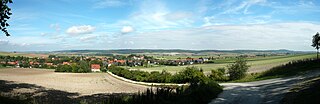
The Vorholz is a ridge up to 243 m high in the districts of Hildesheim and Wolfenbüttel in the German state of Lower Saxony.

Ahlsburg mountain range

The Ahlsburg is a range of bunter sandstone hills, relatively small in area and up to 411.4 m above sea level (NN), in the southern part of Lower Saxony, Germany. It lies within the Solling foreland and is part of the Weser-Leine Uplands.

Elfas mountain range

The Elfas is a range of hills up to 409.6 m above sea level (NN) in the districts of Holzminden and Northeim in Lower Saxony (Germany). Its name is derived from the Lower Saxon word Fast, which means an area of upland that descends on two sides.

Hildesheim Forest mountains in Germany

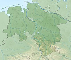
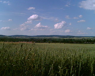
The Hildesheim Forest is a range of hills up to 359 m above sea level (NN) in the district of Hildesheim in the German state of Lower Saxony.

Sieben Berge mountains in Germany

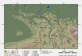
The Sieben Berge are a ridge of hills up to 395 m above sea level (NN) in the Lower Saxon Hills in the district of Hildesheim, Lower Saxony (Germany). Together with the Vorberge and the Sackwald the Sieben Berge belong to the geological formation of the Sackmulde.

Thüster Berg mountain range

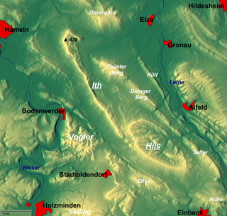
The Thüster Berg is a ridge, up to 441 m above NN, in the Lower Saxon Hills in central Germany. It is situated in the districts of Hameln-Pyrmont and Hildesheim in the federal state of Lower Saxony.

The Sauberge is a hill range up to 317 m above sea level (NN) in the Innerste Uplands in the district of Hildesheim in eastern Lower Saxony in Germany.

Sackwald

The Sackwald is a ridge, up to 374 m above sea level (NN) high, in the Lower Saxon Hills in the district of Hildesheim in the North German state of Lower Saxony. It is named after the village of Sack in the borough of Alfeld, the name meaning "Sack Forest".

Osterwald (hills) mountain range

The Osterwald is a ridge in the Calenberg Uplands and together with the Nesselberg and the Kleiner Deister forms a unified group of three adjacent ranges in the Leine Uplands. It lies between Coppenbrügge, Eldagsen and Elze in the North German state of Lower Saxony.

Selter (hills) mountains in Germany

The Selter is a ridge, up to 395 m above NN, in the Lower Saxon Hills in the districts of Hildesheim, Holzminden and Northeim in the German state of Lower Saxony.

Amtsberge mountain range

The Amtsberge are a relatively small ridge, up to 392.2 m above sea level (NN), near Dassel in southern Lower Saxony in Germany.

Vorberge mountain range

The Vorberge are a ridge, up to 353 m above sea level (NN) high, in the Lower Saxon Hills and within the district of Hildesheim in the German state of Lower Saxony. Together with the Sieben Berge and the Sackwald, the Vorberge belong to the geological formation of the Sackmulde.

Heber (hills) mountain range

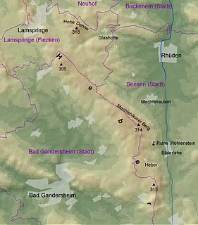
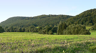
The Heber is a hogback ridge, relatively small in area and up to 313.5 metres high, in the Lower Saxon Hills within the districts of Goslar, Northeim and Hildesheim in the German state of Lower Saxony.

Rotenberg (hills) mountains in Germany

The Rotenberg is a hill range, up to 317.3 m high, in the Lower Saxon Hills in southeastern Lower Saxony, Germany.

The Giesen Hills are a ridge, up to 162.6 metres high, in the district of Hildesheim in the German state of Lower Saxony.

References

  1. Gerzen online