Ambt Montfort is a former municipality in the Dutch province of Limburg.

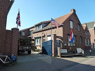
Roerdalen is a municipality in the southeastern Netherlands, in the province of Limburg. As of January 2021, it had about 20580 inhabitants and borders Germany.

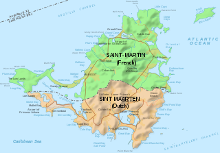
Saint Martin is an island in Leeward Islands of the Lesser Antilles in the northeastern Caribbean, approximately 300 km (190 mi) east of Puerto Rico. The 87 km2 (34 sq mi) island is divided roughly 60:40 between the French Republic and the Kingdom of the Netherlands, but the Dutch part is more populated than the French. Divided since 1648, the northern French part comprises the Collectivity of Saint Martin and is an overseas collectivity of the French Republic. The southern Dutch part comprises Sint Maarten and is one of four constituent countries that form the Kingdom of the Netherlands. Even though the island is an overseas possession of two European Union member states, only the French part of the island is part of the EU.

Sint Eustatius, known locally as Statia, is an island in the Caribbean. It is a special municipality of the Netherlands.

The SSS islands, locally also known as the Windward Islands, is a collective term for the three territories of the Dutch Caribbean that are located within the Leeward Islands group of the Lesser Antilles in the Caribbean Sea. In order of population size, they are: Sint Maarten, Sint Eustatius, and Saba. In some contexts, the term is also used to refer to the entire island of Saint Martin, alongside Sint Eustatius and Saba.

The Sint Maarten national football team is the football team of Sint Maarten, the Dutch half of the Caribbean island of Saint Martin, and is controlled by the Sint Maarten Football Federation. Sint Maarten is not a member of FIFA, and therefore not eligible to enter the World Cup. However, the association applied for FIFA membership in 2016 but was rejected. In April 2022, the Sint Maarten Football Federation appealed to the CAS against FIFA’s ruling.

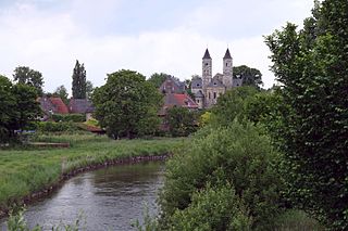
Sint Odiliënberg is a village in southeast Netherlands, It is located in Roerdalen, Limburg, in the Roer River valley.

Vlodrop is a village in the south-eastern part of The Netherlands in the municipality of Roerdalen. The village is situated near the German border, about 8 km southeast of Roermond.

Etsberg is a hamlet in the Dutch province of Limburg. It is a part of the municipality of Roerdalen, and lies about 9 km southeast of Roermond.
Roskam is a hamlet in the Dutch municipality of Roerdalen. It is located between the larger towns of Posterholt and Sint Odiliënberg.

Montfort is a small city in the Dutch province of Limburg. Montfort has about 3,000 inhabitants. It lies about 8 km south of Roermond. It received city rights in 1271 and is renowned for the ruins of Castle Montfort, built in the 13th century.

Sint Maarten is a constituent country of the Kingdom of the Netherlands in the Caribbean region of North America. With a population of 58,477 as of June 2023 on an area of 34 km2 (13 sq mi), it encompasses the southern 44% of the divided island of Saint Martin, while the northern 56% of the island constitutes the French overseas collectivity of Saint Martin. Sint Maarten's capital is Philipsburg. Collectively, Sint Maarten and the other Dutch islands in the Caribbean are often called the Dutch Caribbean.

Posterholt is a village in the Dutch province of Limburg. It is located in the municipality of Roerdalen.

The flag of Sint Maarten consists of a white triangle situated at the hoist charged with the constituent country's coat of arms, along with two horizontal bands of red and blue. Adopted in 1985 shortly after the territory was granted a coat of arms, it has been the flag of Sint Maarten since 13 June of that year. Since the dissolution of the Netherlands Antilles on 10 October 2010, it has been the sole flag used in the constituent country.

Vlodrop-station is a hamlet in the Dutch province of Limburg. It is located on the German border, about 5 km (3.1 mi) east of the village Vlodrop, in the municipality of Roerdalen.

The Kingdom of the Netherlands, commonly known simply as the Netherlands, is a sovereign state consisting of a collection of constituent territories united under the monarch of the Netherlands, who functions as head of state. The realm is not a federation; it is a unitary monarchy with its largest subdivision, the eponymous Netherlands, predominantly located in Northwestern Europe and with several smaller island territories located in the Caribbean.

The Caribbean Netherlands is a geographic region of the Netherlands located outside of Europe, in the Caribbean, consisting of three special municipalities. These are the islands of Bonaire, Sint Eustatius, and Saba, as they are also known in legislation, or the BES islands for short. The islands are officially classified as public bodies in the Netherlands and as overseas territories of the European Union; as such, European Union law does not automatically apply to them.

Sint Hubert is a village in the Dutch province of North Brabant, in the former municipality of Mill en Sint Hubert. Since 2022 it has been part of the municipality of Land van Cuijk.

The COVID-19 pandemic in Sint Maarten, also known as the coronavirus disease 2019 pandemic in Sint Maarten, was a part of the ongoing viral pandemic of coronavirus disease 2019 (COVID-19), which was confirmed to have reached the Dutch Caribbean island of Sint Maarten on 17 March 2020. By 15 June, all cases recovered. On 1 July, a new case had been discovered, which resolved on 3 July On 15 July, a 79th case was discovered.

The COVID-19 pandemic in Sint Eustatius is part of the ongoing global viral pandemic of coronavirus disease 2019 (COVID-19), which was confirmed to have reached the Dutch Caribbean island of Sint Eustatius on 31 March 2020. On 5 May all cases recovered. The island's first COVID-19 death was recorded on 19 January 2022. The patient died at the St. Maarten Medical Center (SMCC) where they had been transported for treatment according to the press release of the St. Eustatius government.


