History
Reynolds Park lies within an area that in the 19th century was the estate of a series of wealthy local businessmen.
In the late 19th century it came into the possession of the Reynolds family, who had made their fortune in the cotton trade.
In 1929 James Reynolds, last owner of the estate, donated it to the City Corporation, though his daughter continued to live at the park and was active in its development as an amenity.
Colonel Sir James Philip Reynolds, 1st Baronet, DSO was an English businessman and Conservative Party politician.
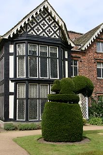
In 1975 the mansion was destroyed by fire, and was replaced by a housing scheme for the elderly.
Layout
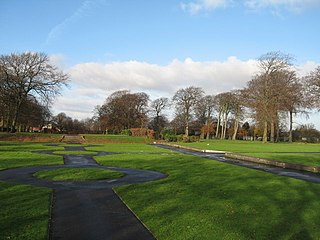
The park comprises 14-acre (57,000 m2) area of open lawns, formal gardens and woodland on a sloping east-facing site.
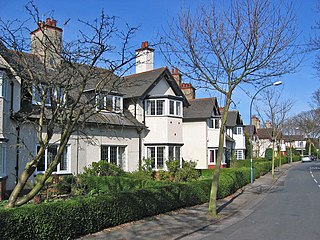
It is bounded by Church Road to the west, Woolton Hill Road to the north and Woolton Park Road to the south and east, and is surrounded by a high sandstone wall. There are entrances from the various roads, with the main entrances guarded by lodges. These originally gave accommodation for the gardeners, and continued to do so when it became a public park, but are now in private hands. The mansion house has also disappeared and there is private housing on the site.
The park lies within Woolton conservation area contains a number of listed features.
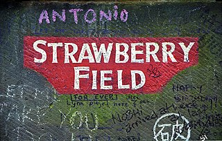
Strawberry Field was a Salvation Army children's home in Woolton, a suburb of Liverpool, England.

Saint Annes Park is a 240 acres (97 ha) public park situated between Raheny and Clontarf, suburbs on the northside of Dublin, Ireland. It is owned and managed by Dublin City Council.

Mount Merrion is a suburban area of Dublin, Ireland. It is roughly 7 kilometres (5 mi) south of Dublin city centre and is situated on and around the hill of the same name.

Castle Coole is a townland and a late-18th-century neo-classical mansion situated in Enniskillen, County Fermanagh, Northern Ireland. Set in a 1,200-acre (490 ha) wooded estate, it is one of three properties owned and managed by the National Trust in County Fermanagh, the others being Florence Court and the Crom Estate.

Belle Vale is a district of south-east Liverpool, Merseyside, England and a Liverpool City Council Ward that covers both Belle Vale and Netherley.

The English city of Bristol has a number of parks and public open spaces.

The Woodlands is a National Historic Landmark District on the west bank of the Schuylkill River in Philadelphia. It includes a Federal-style mansion, a matching carriage house and stable, and a garden landscape that in 1840 was transformed into a Victorian rural cemetery with an arboretum of over 1,000 trees. More than 30,000 people are buried at the cemetery.

Grangewood Park is an extensive woodland area situated in South Norwood, London. It is managed by the London Borough of Croydon. It is bounded by Grange Road, Wharncliffe Road, and Ross Road. It covers an area of 273⁄4 acres 11.23 hectares. The park is located on the main A212 road between Thornton Heath and Upper Norwood/Crystal Palace. The nearest stations are Thornton Heath, Selhurst and Norwood Junction.
Liverpool, England, UK has a significant area of public parks and gardens. The English Heritage National Register of Historic Parks describes Merseyside’s Victorian Parks as collectively the "most important in the country". The city of Liverpool has ten listed parks and cemeteries, including two Grade I and five Grade II*, more than any other English city apart from London.

Woodland Crest is a private housing estate in Sheung Shui, New Territories, Hong Kong. It was developed by Sun Hung Kai Properties, and is managed by Hong Yip Service Co. Ltd. It has a total of 548 apartments, and was completed in May 1996. Sun Hung Kai initiated the development of smart cards in the residential complex early in 1996, the first of its kind.
Bingley St. Ives, or St. Ives Estate is a 550-acre (2.2 km2) country park
and former estate between Bingley and Harden in West Yorkshire, England now owned by Bradford Council.
The park has Grade II listing in the English Heritage National Register of Historic Parks and Gardens of Special Interest.
The park has been given Accredited Country Park status by Natural England.

Woolton Woods and Camp Hill is a wooded park in the Woolton suburb of Liverpool in England. It is adjacent to St Julie's Catholic High School and Woolton High Street. Woolton Woods formed part of the estate of Woolton Hall, but was acquired by the city of Liverpool in the 1920s.

The Boston Post Road Historic District is a 286-acre (116 ha) National Historic Landmark District in Rye, New York, and is composed of five distinct and adjacent properties. Within this landmarked area are three architecturally significant, pre-Civil War mansions and their grounds; a 10,000-year-old Paleo-Indian site and viewshed; a private cemetery, and a nature preserve. It is one of only 11 National Historic Landmark Districts in New York State and the only National Historic Landmark District in Westchester County. It touches on the south side of the nation's oldest road, the Boston Post Road, which extends through Rye. A sandstone Westchester Turnpike marker "24", inspired by Benjamin Franklin's original mile marker system, is set into a wall that denotes the perimeter of three of the contributing properties. The district reaches to Milton Harbor of Long Island Sound. Two of the properties included in the National Park designation are anchored by Greek Revival buildings; the third property is dominated by a Gothic Revival structure that was designed by Alexander Jackson Davis.

Peel Park is a 22.6-hectare (56-acre) urban public park in the Bolton and Undercliffe area of Bradford, England, located about 0.75 miles (1.2 km) north-east of the city centre, and named after Sir Robert Peel (1788-1850).
Peel Park was Bradford's first public park and is on the English Heritage and National Register of Historic Parks and Gardens online databases.
The park is a Green Flag Award winner and has been for a number of years.

Woodward Park is a 45-acre (18 ha) public park, botanical garden, and arboretum located between 21st Street and 24th Street east of South Peoria Avenue and west of South Rockford Street in Tulsa, Oklahoma, in the Midwestern United States. The park, named for Helen Woodward, the original property owner, was established in 1929, after a lengthy court suit over ownership.
Woolton Hill is a village in Hampshire, England, within the civil parish of East Woodhay. The village is situated approximately 10 kilometres south-west of Newbury and encompasses the smaller hamlet of Broad Layings within its Northern borders. It has a church, church (village) hall, sports club, youth football club, post office, nursery, infants and junior schools and a pub.
The Garden Village is an area of model village housing built in the early 1900s, in the Summergangs area of Kingston upon Hull, England, for the workers of Reckitt & Sons.
Gwydyr Mansions is a block of mansion flats in the centre of Hove, part of the English coastal city of Brighton and Hove. Built on the initiative of a Baptist pastor and designed by the prolific architecture firm of Clayton & Black, the "elegant" Flemish Renaissance-style building dates from 1890 and overlooks a central square. As originally built, the block had a restaurant and barber shop for residents; the latter is still operational.
Norris Green Park in Norris Green, Liverpool, England is a city park situated between Broad Lane and Lorenzo Drive.

Firth Park is a public park in the Firth Park area of the City of Sheffield in England. It is located 3.75 km north-northeast of the city centre. The main entrance to the park is on Hucklow Road although there are several entrances on Firth Park Road to the east and one on Vivian Road to the south. Established in 1875, the park gave its name to the Sheffield suburb of Firth Park, a social housing estate constructed around the area of the park in the 1920s and 1930s.