
Bodmin is a civil parish and historic town in Cornwall, England, United Kingdom. It is situated south-west of Bodmin Moor.
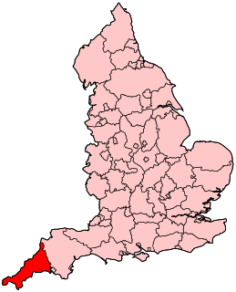
Cornwall is a ceremonial county in South West England, bordered to the north and west by the Celtic Sea, to the south by the English Channel, and to the east by Devon, the River Tamar forming the border between them. Cornwall is the westernmost part of the South West Peninsula of the island of Great Britain. The southwesternmost point is Land's End and the southernmost Lizard Point. Cornwall has a population of 568,210 and an area of 3,563 km2 (1,376 sq mi). The county has been administered since 2009 by the unitary authority, Cornwall Council. The ceremonial county of Cornwall also includes the Isles of Scilly, which are administered separately. The administrative centre of Cornwall is Truro, its only city.

Devon, also known as Devonshire, is a county of England, reaching from the Bristol Channel in the north to the English Channel in the south. It is part of South West England, bounded by Cornwall to the west, Somerset to the north east, and Dorset to the east. The city of Exeter is the county town. The county includes the districts of East Devon, Mid Devon, North Devon, South Hams, Teignbridge, Torridge, and West Devon. Plymouth and Torbay are each geographically part of Devon, but are administered as unitary authorities. Combined as a ceremonial county, Devon's area is 6,707 km2 and its population is about 1.1 million.

Newquay is a town on the north coast in Cornwall, in the south west of England. It is a civil parish, seaside resort, regional centre for aerospace industries, future spaceport and a fishing port on the North Atlantic coast of Cornwall, approximately 12 miles (19 km) north of Truro and 20 miles (32 km) west of Bodmin.
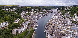
Looe is a small coastal town, fishing port and civil parish in south-east Cornwall, England, with a population of 5,280 at the 2011 census.

Cornwall is a town in Litchfield County, Connecticut, United States. The population was 1,420 at the 2010 census.

Cornwall is a city in Eastern Ontario, Canada, and the seat of the United Counties of Stormont, Dundas and Glengarry. Cornwall is Ontario's easternmost city, located on the Saint Lawrence River in the Quebec City–Windsor Corridor along Ontario Highway 401, and is the urban centre for surrounding communities, including Long Sault and Ingleside to the west, Mohawk Territory of Akwesasne to the south, St. Andrew's and Avonmore to the north, and Glen Walter, Martintown, Apple Hill, Williamstown, and Lancaster to the east.

Liskeard is an ancient stannary and market town and civil parish in south east Cornwall, England, United Kingdom.

Callington is a civil parish and town in east Cornwall, England, United Kingdom about 7 miles (11 km) north of Saltash and 9 miles (14 km) south of Launceston.
The history of Cornwall goes back to the Paleolithic, but in this period Cornwall only had sporadic visits by groups of humans. Continuous occupation started around 10,000 years ago after the end of the last ice age. When recorded history started in the first century BCE, the spoken language was Common Brittonic, and that would develop into Southwestern Brittonic and then the Cornish language. Cornwall was part of the territory of the tribe of the Dumnonii that included modern-day Devon and parts of Somerset. After a period of Roman rule, Cornwall reverted to rule by independent Romano-British leaders and continued to have a close relationship with Brittany and Wales as well as southern Ireland, which neighboured across the Celtic Sea. After the collapse of Dumnonia, the remaining territory of Cornwall came into conflict with neighbouring Wessex.

St Columb Major is a town and civil parish in Cornwall, England, United Kingdom. Often referred to locally as St Columb, it is approximately seven miles (11 km) southwest of Wadebridge and six miles (10 km) east of Newquay The designation Major distinguishes it from the nearby settlement and parish of St Columb Minor on the coast. An electoral ward simply named St Columb exists with a population at the 2011 census of 5,050.
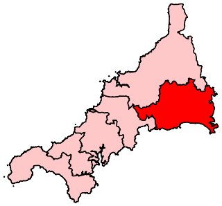
South East Cornwall is a constituency represented in the House of Commons of the UK Parliament since 2010 by Sheryll Murray, a Conservative.

Cornwall is administered as a county of South West England whose politics are influenced by a number of issues that make it distinct from the general political scene in the wider United Kingdom, and the political trends of neighbouring counties. Its position on the geographical periphery of the island of Great Britain is also a factor.
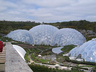
The economy of Cornwall in South West England, is largely dependent upon agriculture followed by tourism. Cornwall is one of the poorest areas in the United Kingdom with a GVA of 70.9% of the national average in 2015. and is one of four UK areas that qualifies for poverty-related grants from the EU. Farming and food processing contributed £366 million to the county, equal to 5.3% of Cornwall’s total GVA. The agricultural/food industry in Cornwall employs 9,500 people, 23,700 are employed in the food industry in Cornwall The Cornish economy also depends heavily on its successful tourist industry which contributes 24% of Cornwall's GDP and supports about 1 in 5 jobs. Tourism contributed £1.85 billion to the Cornish economy in 2011.
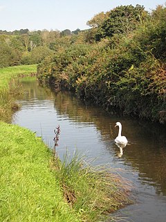
The River Cober is a short river in west Cornwall, England, United Kingdom. It rises in Nine Maidens Downs, directly between Hangman's Barrow to the west and the Nine Maidens stone circle to the east, in the former Kerrier District and runs to the west of the town of Helston before entering the largest natural lake in Cornwall – Loe Pool. The water is impounded by the natural barrier, Loe Bar, and the river system can be traced several kilometres out into Mount's Bay. Mining activity of over one hundred years in the river catchment, ceased in 1938, in the Wendron and Porkellis mining districts; and the engine house of Castle Wary, near Nansloe can still be seen on the east side of the river below Helston. The lower reaches of river was canalised in 1946 and a causeway built over Loe Marsh in 1987. The meaning of the name is uncertain, but two of the earliest records are: "in 1260 we find, 'Chohor' [alternately known as in non-unified Cornish: Dowr Coghar, meaning 'scarlet river', due to its earlier colour from mining waste] and a few years later, 'Coffar'". The present name 'Cober' is unlikely to be derived from 'Coffar', since it was known as the 'River Loe or River Looe' around four hundred years ago, in Carew's time, according to the map of Powder Hundred.
The Cornish dialect is a dialect of English spoken in Cornwall by Cornish people. Dialectal English spoken in Cornwall is to some extent influenced by Cornish grammar, and often includes words derived from the Cornish language. The Cornish language is a Celtic language of the Brythonic branch, as are the Welsh and Breton languages. In addition to the distinctive words and grammar, there are a variety of accents found within Cornwall from the north coast to that of the south coast and from east to west Cornwall. Typically, the accent is more divergent from Standard British English the further west through Cornwall one travels. The speech of the various parishes being to some extent different from the others was described by John T. Tregellas and Thomas Q. Couch towards the end of the 19th century. Tregellas wrote of the differences as he understood them and Couch suggested the parliamentary constituency boundary between the East and West constituencies, from Crantock to Veryan, as roughly the border between eastern and western dialects. To this day, the towns of Bodmin and Lostwithiel as well as Bodmin Moor are considered the boundary.
The 2011–12 South West Peninsula League season was the fifth in the history of the South West Peninsula League, a football competition in England, that feeds the Premier Division of the Western Football League. The league had been formed in 2007 from the merger of the Devon County League and the South Western League, and is restricted to clubs based in Cornwall and Devon. The Premier Division of the South West Peninsula League is on the same level of the National League System as the Western League Division One.

The River Kensey is a river in east Cornwall, England, UK which is a tributary of the River Tamar.

The River Seaton is a river in east Cornwall, England, UK which flows southwards for 11 miles (17 km) into the English Channel.
The following outline is provided as an overview of and topical guide to Cornwall: Cornwall – ceremonial county and unitary authority area of England within the United Kingdom. Cornwall is a peninsula bordered to the north and west by the Celtic Sea, to the south by the English Channel, and to the east by the county of Devon, over the River Tamar. Cornwall is also a royal duchy of the United Kingdom. It has an estimated population of half a million and it has its own distinctive history and culture.


