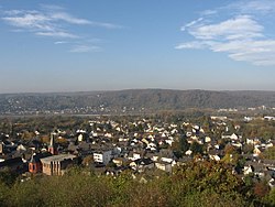
Rheinbreitbach

Last updated
Rheinbreitbach
Rheinbreitbach overview-20051030.jpg
Rheinbreitbach.png
Coat of arms
Location of Rheinbreitbach within Neuwied district
Rheinbreitbach in NR.svg
Germany adm location map.svg
Red pog.svg
Rheinbreitbach
Rhineland-Palatinate location map.svg
Red pog.svg
Rheinbreitbach
Coordinates: 50°37′13″N7°13′51″E / 50.62028°N 7.23083°E / 50.62028; 7.23083 Coordinates: 50°37′13″N7°13′51″E / 50.62028°N 7.23083°E / 50.62028; 7.23083
Country Germany
State Rhineland-Palatinate
District Neuwied
Municipal assoc. Unkel
Government
   Mayor (201924) Roland Thelen [1] (CDU)
Area
  Total6.58 km2 (2.54 sq mi)
Elevation
75 m (246 ft)
Population
 (2020-12-31) [2]
  Total4,473
  Density680/km2 (1,800/sq mi)
Time zone UTC+01:00 (CET)
  Summer (DST) UTC+02:00 (CEST)
Postal codes
53619
Dialling codes 02224
Vehicle registration NR
Website www.rheinbreitbach.de

Rheinbreitbach is a municipality in the district of Neuwied, in north of Rhineland-Palatinate, bordering North Rhine-Westphalia in Germany. Administratively it belongs to the municipality (Verbandsgemeinde) of Unkel. The town is an officially recognized Fremdenverkehrsort (touristic locality).

Contents

Geography

Rheinbreitbach is located at the north end of the Middle Rhine and at the southern edge of the Siebengebirge. As a whole it is part of the Rhine Westerwald Volcanic Ridge (Rheinwesterwälder Vulkanrücken). The dimensions of its territory are approximately 7 (east–west) by 2 kilometres, its highest point is 375 m, near the summit of the Asberg. Most of the 6,58 km2 area is forested (56.6%) and only a small portion is used agriculturally (8.5%).

History

The town, presumably founded in Frankish times is first mentioned in official documents in 966 under the name Breitenbach, but finds of coins dated from 150 to 350 AD near the mining operation Virneberg (or Firneberg) shows Roman presence in the region, presumably mining copper. In the Middle Ages the town was surrounded by a wall and moat and sported four fortified gates. The town is first called "Rheinbreitbach" in 1604.

Mining

The mining of copper-ore and subsequent extraction of the copper is attested by various finds since mediaeval times in near the Virneberg, in Breite Heide. In 1604, one Bartholomäus Brück reopens the royal copper mines. In 1720 the complex had nearly a kilometer of shafts, and in 1744 eighty employees are registered. In this time the mine is renamed St. Jozefsstollen. In 1756 a document mentions the use of 8000 pounds of Breitbacher kupfer to cast the bells of the Bonn Minster. The mines are visited by a young Alexander von Humboldt during a study trip in 1789. In 1794 production was temporarily halted, but a new shaft, started in 1800 to a depth of 85 meters rendered the mine productive again. In 1840 the 51 miners produced 8500 tons of ore. In 1867 production came to a standstill once again at a depth of 138 meters. Another new shaft was drilled in 1870 reaching a depth of 255 meters, 117 meters below the Rhine, in 1880 but the operation was abandoned in 1886.

Viticulture

Apart from mining, viticulture was a large part of the local economy. The first vineyard to be mentioned is that of Kloster Rolandswerth, the current Nonnenwerth in 1143. The monasteries of Marienstatt and Schwarz-Rheindorf also grew wine here, as did the churches of St. Aposteln, St. Severin, St. Maria ad Gradus, St. Gereon and St. Martin. Also the local gentry, the, Freiherrn von Breidbach and even the Counts of Berg owned vineyards here.

The populace was employed on these estates as tenants, the so-called halfen, who owed half or a third of the produce to their landlords, the clergy and the nobility. To prevent the stealing of grapes, special Traubenhüter (grape guards) were employed by the community. In 1661 110 vineyards are registered. The year 1889 is still remembered as a top year, grossing an estimated 100,000 Marks. In the 20th century, however, viticulture in the community went into decline due to infestations of Reblaus . Currently there are no vineyards in Rheinbreitbach.

See also

Related Research Articles

Oppenheim Place in Rhineland-Palatinate, Germany

Oppenheim is a town in the Mainz-Bingen district of Rhineland-Palatinate, Germany. The town is a well-known wine center, being the home of the German Winegrowing Museum, and is particularly known for the wines from the Oppenheimer Krötenbrunnen vineyards.

Linz am Rhein Place in Rhineland-Palatinate, Germany

Linz am Rhein is a municipality in the district of Neuwied, in Rhineland-Palatinate, Germany. It is situated on the right bank of the river Rhine near Remagen, approx. 25 km southeast of Bonn and has about 6,000 inhabitants. It is the sister city of Marietta, Georgia in the United States, Linz in Austria and Pornic in France.

Bad Ems Place in Rhineland-Palatinate, Germany

Bad Ems is a town in Rheinland Pfalz, Germany. It is the administrative seat of the Rhein-Lahn rural district and is well known as a spa on the river Lahn. Bad Ems is the seat of the Verbandsgemeinde Bad Ems-Nassau. The town has around 9,000 inhabitants.

Bendorf Place in Rhineland-Palatinate, Germany

Bendorf is a town in the district of Mayen-Koblenz, in Rhineland-Palatinate, Germany, on the right bank of the Rhine, approx. 7 kilometres north of Koblenz.

Bad Hönningen Place in Rhineland-Palatinate, Germany

Bad Hönningen is a municipality in the district of Neuwied, in Rhineland-Palatinate, Germany. It is situated on the right bank of the Rhine, approx. 15 km (10 mi) northwest of Neuwied, and 30 km (20 mi) southeast of Bonn.

Unkel Place in Rhineland-Palatinate, Germany

Unkel is a town in the district of Neuwied, in Rhineland-Palatinate, Germany. It is situated on the right bank of the Rhine, near Remagen, about 20 km southeast of Bonn.

Graach an der Mosel Place in Rhineland-Palatinate, Germany

Graach an der Mosel is an Ortsgemeinde – a municipality belonging to a Verbandsgemeinde, a kind of collective municipality – in the Bernkastel-Wittlich district in Rhineland-Palatinate, Germany.

Piesport Place in Rhineland-Palatinate, Germany

Piesport is an Ortsgemeinde – a municipality belonging to a Verbandsgemeinde, a kind of collective municipality – in the Bernkastel-Wittlich district in Rhineland-Palatinate, Germany.

Gimbsheim Place in Rhineland-Palatinate, Germany

Gimbsheim is an Ortsgemeinde – a municipality belonging to a Verbandsgemeinde, a kind of collective municipality – in the Alzey-Worms district in Rhineland-Palatinate, Germany.

Obersülzen Place in Rhineland-Palatinate, Germany

Obersülzen is an Ortsgemeinde – a municipality belonging to a Verbandsgemeinde, a kind of collective municipality – in the Bad Dürkheim district in Rhineland-Palatinate, Germany. It lies in the northwest of the Rhine-Neckar urban agglomeration.

Niederhausen Place in Rhineland-Palatinate, Germany

Niederhausen is an Ortsgemeinde – a municipality belonging to a Verbandsgemeinde, a kind of collective municipality – in the Bad Kreuznach district in Rhineland-Palatinate, Germany. It belongs to the Verbandsgemeinde of Rüdesheim, whose seat is in the like-named town. Niederhausen is a state-recognized tourism community (Fremdenverkehrsort) and a winegrowing village.

Kurtscheid Place in Rhineland-Palatinate, Germany

Kurtscheid is a municipality in the district of Neuwied, in northern Rhineland-Palatinate, Germany. The village is located in the natural preserve Rhein-Westerwald. Kurtscheid is 401 metres above sea level and is hence the highest municipality in the district of Neuwied.

Melsbach Place in Rhineland-Palatinate, Germany

Melsbach is a municipality in the district of Neuwied, in Rhineland-Palatinate, Germany. Since 2018, it is part of the Verbandsgemeinde Rengsdorf-Waldbreitbach.

Sommerloch Place in Rhineland-Palatinate, Germany

Sommerloch is a municipality in the district of Bad Kreuznach administrative region in Rhineland-Palatinate, in western Germany.

Weingarten, Rhineland-Palatinate Place in Rhineland-Palatinate, Germany

Weingarten is a municipality in the district of Germersheim, in Rhineland-Palatinate, Germany.

Altlay Place in Rhineland-Palatinate, Germany

Altlay is an Ortsgemeinde – a municipality belonging to a Verbandsgemeinde, a kind of collective municipality – in the Cochem-Zell district in Rhineland-Palatinate, Germany. It belongs to the Verbandsgemeinde of Zell, whose seat is in the municipality of Zell an der Mosel.

Laurenburg Place in Rhineland-Palatinate, Germany

Laurenburg is a municipality in the Rhein-Lahn district of Rhineland-Palatinate, in western Germany. The town, a health resort situated in the lower Lahn River valley, belongs to the Diez Municipal Association.

Mohawk Mining Company

The Mohawk Mining Company was a major copper mining company, based in the Keweenaw Peninsula of Michigan, that was established in November 1898 and lasted until 1932. The company, between 1906 and 1932, paid out more than $15 million in shareholder dividends. The Mine is best known for the large amounts of mohawkite that were found on the property. The Mohawk mine operated until 1932; in 1934 it was purchased by the Copper Range Company.

Middle Rhine Basin

The Middle Rhine Basin is the central landscape region of the Middle Rhine in Germany and, along with the Limburg Basin, forms one of the biggest intra-montane lowland regions within the Rhenish Massif. The basin is divided into the valley bottom of the Neuwied Basin, the Neuwied Basin Perimeter east of the Rhine and the Lower Moselle Valley west of the Rhine in the south, and the Maifeld-Pellenz Hills in the north.

The Nordfeld Consolidated Coal Mine was a large-scale but ultimately short-lived and unsuccessful German mining operation on the border of the present-day states of Saarland and Rhineland-Palatinate (Rheinland-Pfalz). It existed from 1889 and 1905 in the Pfaffen Woods (Pfaffenwald) on the northern slope of Höcherberg in the vicinity of the Saarland town of Höchen and the Rheinland-Pfalz towns of Waldmohr and Dunzweiler. The mine's second shaft, named "Wilhelmine," was the deepest in the entire Saar area at the time.

References

  1. Direktwahlen 2019, Landkreis Neuwied, Landeswahlleiter Rheinland-Pfalz, accessed 5 August 2021.
  2. "Bevölkerungsstand 2020, Kreise, Gemeinden, Verbandsgemeinden". Statistisches Landesamt Rheinland-Pfalz (in German). 2021.