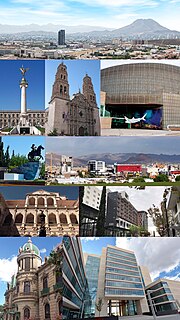
The city of Chihuahua is the state capital of the Mexican state of Chihuahua. As of 2017, the city of Chihuahua had a population of 878,062 inhabitants. while the metropolitan area had a population of 1,036,806 inhabitants.

Durango, officially Free and Sovereign State of Durango, is a state in northwest Mexico. With a population of 1,632,934, Durango has Mexico's second-lowest population density, after Baja California Sur. The city of Victoria de Durango is the state's capital, named after the first president of Mexico, Guadalupe Victoria.

Chihuahua is a state in Northwest Mexico that is divided into 67 municipalities. According to the 2015 Mexican Intercensal Survey, Chihuahua is the 11th most populous state with 3,554,877 inhabitants and the largest by land area spanning 247,798.08 square kilometres (95,675.37 sq mi).

Creel is a town in the Sierra Tarahumara of the Mexican state of Chihuahua. It is the second-largest town in the municipality of Bocoyna. It is located some 175 kilometres (109 mi) to the southwest of the state capital, Chihuahua City. At the census of 2010, it had a population of 5,026, down from 5,338 as of 2005.

Quercus emoryi, the Emory oak, is a species of oak common in Arizona, New Mexico and western Texas, United States, and northern Mexico. It typically grows in dry hills at moderate altitudes.
Nueva Vizcaya was the first province in the north of New Spain to be explored and settled by the Spanish. It consisted mostly of the area which is today the states of Chihuahua and Durango in Mexico.

The Cumbres de Majalca National Park is a national park in the Mexican state of Chihuahua located 88 km northwest of the city of Chihuahua. The park showcases extraordinary rock formations that have been shaped by wind and water erosion. The park was created by presidential decree in 1939 encompassing 4,772 hectares to protect the endemic flora and fauna. The park is characterized by pine and oak forest. The park is one of the few areas in Mexico that are inhabited by black bear.

According to the 2012 estimates, there were 100,000 Mennonites living in Mexico, the vast majority of them, or about 90,000 are established in the state of Chihuahua, 6,500 were living in Durango, with the rest living in small colonies in the states of Campeche, Tamaulipas, Zacatecas, San Luis Potosí and Quintana Roo.
Federal Highway 24 is a free part of the federal highways corridors. Fed. 24 is intended to cross the Sierra Madre Occidental from the area of Hidalgo del Parral, Chihuahua, on the east, to the area of Culiacán, Sinaloa, on the west. A limited central section of about 40 to 50 km is not yet completed or graded. This section lies between the villages of Los Frailes, Durango, on the east, and Soyatita, Sinaloa, on the west. Travel is possible through this area, where the road is not yet completed, on unimproved roads using high clearance two-wheel drive vehicles. The two unconnected segments that extend through Los Frailes and Soyatita are graded, but each segment is unpaved for about the last 75 km. The central gap in the highway is in the rugged mountains of the Sierra Madre Occidental. This uncompleted and unpaved portion of the road is not well signed, there are many intersections with other unimproved roads, and it is easy to get lost off the intended route of the highway. As noted later, getting lost may not be a safe proposition. Further, the unfinished segment on the west is at about 820 meters elevation at Soyatita. Just outside Los Frailes, the road coming from the east is at 2,750 meters elevation. The traveler crossing this gap will have to negotiate this dramatic change in elevation traveling a good deal of the way on unimproved dirt roads. Travel times in this central section can be quite slow.
Asanthus is a small genus of flowering plants in the daisy family, found only in northern Mexico and the southwestern United States.

Chihuahua, officially the Free and Sovereign State of Chihuahua, is one of the 31 states of Mexico. It is located in Northwestern Mexico and is bordered by the states of Sonora to the west, Sinaloa to the southwest, Durango to the south, and Coahuila to the east. To the north and northeast, it has a long border with the U.S. adjacent to the U.S. states of New Mexico and Texas. Its capital city is Chihuahua City.

The Tamá National Natural Park is a national park located in the Tamá Massif of the Andean Region of Colombia, between the municipalities Toledo and Herrán, in the department of Norte de Santander, in the northeastern part of the Eastern Ranges of the Colombian Andes. One of the main attractions of the park is a 820-metre-high (2,690 ft) waterfall, one of the world's highest.
The National System of Protected Areas (SINAP) is the Colombian national park administrator. It is a department under the Ministry of the Environment, Housing and Regional Development responsible for the conservation and sustainable use of biological diversity. SINAP was established after Colombia signed the Convention on Biological Diversity through Law 165 of 1994, and has been the primary activity of the Colombian Government regarding the conservation of biodiversity. The areas of the Park System supply 25 million people with water.
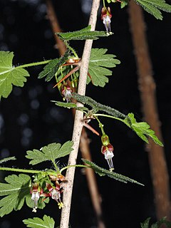
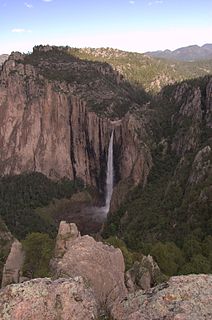
Symphoricarpos palmeri, common name Palmer's snowberry, is a North American species of plants in the Honeysuckle Family. It has been found in the southwestern United States, as well as in the Mexican State of Chihuahua inside Basaseachic Falls National Park.

Northern Mexico, commonly referred as El Norte, is an informal term for the northern cultural and geographical area in Mexico. Depending on the source, it contains some or all of the states of Baja California, Baja California Sur, Chihuahua, Coahuila, Durango, Nuevo León, Sinaloa, Sonora and Tamaulipas.