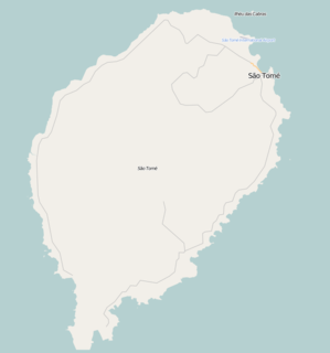
Santana is a town on the eastern coast of São Tomé Island, which is part of the island nation of São Tomé and Príncipe. It is the seat of Cantagalo District. The population of Santana with the adjacent settlements Cidade Alta, Cova Água, Gomes, Nova Olinda, Picão Flor, Praia Messias Alves, Riboque Santana and Zandrigo is 10,290 (2012). Santana lies 9 km south of the capital São Tomé and 17 km northeast of São João dos Angolares. The islet Ilhéu de Santana lies about 1 km off-shore, 2.5 km southeast of Santana.

Água Izé is a village on São Tomé Island. Its population is 1,255. It lies on the coast, 4 km northeast of Ribeira Afonso and 5 km southwest of Santana. The most notable landmark is Roça Água Izé, a former plantation complex. Most of the preserved buildings date from the 1910s.
Blublu is a small village on São Tomé Island in São Tomé and Príncipe. Its population is 19. It lies 0.7 km southeast of Bobo Forro and 3 km southwest of the city centre of the capital São Tomé.
Quinta da Graça is a village on São Tomé Island in São Tomé and Príncipe. Its population is 58. It lies directly east of Monte Café, 2 km west of Batepá.
Nova Olinda is a village in the eastern part of São Tomé Island in São Tomé and Príncipe. Its population is 107. It lies 2 km southwest of Santana.
Santa Clotilde is a village in the eastern part of São Tomé Island in São Tomé and Príncipe. Its population is 112. It lies 6 km west of Santana.
Java is a village on São Tomé Island in the nation of São Tomé and Príncipe. Its population is 19. It was established as a plantation (roça).
Caixão Grande is a town on São Tomé Island in the nation of São Tomé and Príncipe. Its population is 1,021. It lies about 5 km southwest of the national capital São Tomé.
Almeirim is a village on São Tomé Island in the nation of São Tomé and Príncipe. Its population is 1,591. It is in the southern part of the Água Grande District and borders the city São Tomé to the northeast.
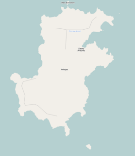
Sundy is a settlement in the northwestern part of Príncipe Island in São Tomé and Príncipe. Its population is 416. Sundy lies 5 km northwest of the island capital of Santo António. In 1822 the first cocoa plantation of the whole archipelago was established in Sundy. Several buildings of this plantation have been preserved.
São Marçal is a suburb of the city São Tomé in the nation of São Tomé and Príncipe. Its population is 2,866. It is 2.3 km southeast of the city centre of São Tomé and 1 km northwest of Pantufo.
São João da Vargem is a suburb of the city São Tomé in the nation of São Tomé and Príncipe. Its population is 1,793. It lies on the coast, 1 km northwest of the city centre of São Tomé.
Zandrigo is a settlement in Cantagalo District, São Tomé Island in the nation of São Tomé and Príncipe. Its population is 765. It lies directly west of Santana.
Cova Água is a settlement in Cantagalo District, São Tomé Island in the nation of São Tomé and Príncipe. Its population is 363. It lies on the coast, directly north of Santana.
Picão Flor is a settlement in Cantagalo District, São Tomé Island in the nation of São Tomé and Príncipe. Its population is 1,911. It lies 1.2 km southwest of Santana.
Praia Messias Alves is a settlement in Cantagalo District, São Tomé Island in the nation of São Tomé and Príncipe. Its population is 466. It lies on the coast, 1.2 km south of Santana and 0.5 km east of Picão Flor.
Cidade Alta is a settlement in Cantagalo District, São Tomé Island in the nation of São Tomé and Príncipe. Its population is 212. It lies directly northwest of Santana.
Aeroporto is a settlement in the northern part of Príncipe Island in São Tomé and Príncipe. Its population is 243. Aeroporto settlement lies directly east of the Príncipe Airport and north of the island capital Santo António.
Ponta Mina is a subdivision of the city São Tomé in the nation of São Tomé and Príncipe. Its population is 984. It lies directly east of the city center of São Tomé.