Cantagalo is a district of São Tomé and Príncipe, on São Tomé Island. Its area is 119 km2 (46 sq mi), and its population is 17,161 (2012). The district seat is Santana. It is divided into the two statistical subdistricts Santana and Ribeira Afonso.

Caué is a district of São Tomé and Príncipe, on São Tomé Island. Covering 267 km2 (103 sq mi), it is the largest of the nation's seven districts in terms of area. In population it is the smallest, with 6,031 residents (2012). The district seat is São João dos Angolares. It is divided into the two statistical subdistricts São João dos Angolares and Malanza.

Ilhéu das Rolas is an islet in the African island nation of São Tomé and Príncipe. The island lies on the equator, off the southern tip of São Tomé Island, separated by Canal das Rolas. Its maximum elevation is 96 m. Its population is 76. It is part of the Caué District. Access is only by ferry departing from Ponta Baleia on São Tomé Island. There is a lighthouse on the islet, built in 1929. Its focal height is 106 meters and its range is 12 nmi. The island is home to a small resort, the Pestana Equador.
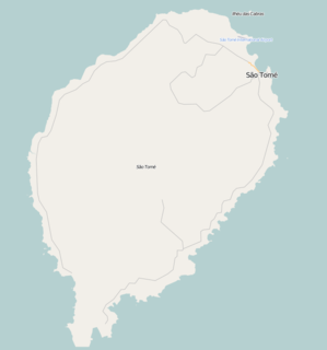
Santa Cruz is a village on São Tomé Island in the nation of São Tomé and Príncipe. Its population is 191. It lies 1 km north of Santa Margarida and 1 km west of Madalena.
Blublu is a small village on São Tomé Island in São Tomé and Príncipe. Its population is 19. It lies 0.7 km southeast of Bobo Forro and 3 km southwest of the city centre of the capital São Tomé.
Bombom is a town in the north-eastern part of São Tomé Island in São Tomé and Príncipe. Its population is 498. It lies 2 km west of Pantufo and 3 km south of the city centre of the capital São Tomé.
Java is a village on São Tomé Island in the nation of São Tomé and Príncipe. Its population is 19. It was established as a plantation (roça).
Lemos is a village on São Tomé Island in the nation of São Tomé and Príncipe. Its population is 1,136. It is 2 km east of Trindade.
Caixão Grande is a town on São Tomé Island in the nation of São Tomé and Príncipe. Its population is 1,021. It lies about 5 km southwest of the national capital São Tomé.
Almeirim is a village on São Tomé Island in the nation of São Tomé and Príncipe. Its population is 1,591. It is in the southern part of the Água Grande District and borders the city São Tomé to the northeast.

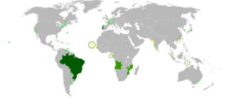
São Tomé and Príncipe, officially the Democratic Republic of São Tomé and Príncipe, is an island country in the Gulf of Guinea, off the western equatorial coast of Central Africa. It consists of two archipelagos around the two main islands of São Tomé and Príncipe, about 140 kilometres apart and about 250 and 225 kilometres off the northwestern coast of Gabon, respectively.
Batepá is a village on São Tomé Island in São Tomé and Príncipe. Its population is 775. It lies 2 km west of Trindade and 2 km east of Monte Café. It was the starting point of the Batepá massacre, a brutally crushed rebellion in February 1953, in which hundreds of local inhabitants were killed. It marked the rise of the independence movement in Portuguese São Tomé and Príncipe, and is commemorated annually as a national holiday on February 3.
Piedade is a village on São Tomé Island in São Tomé and Príncipe. Its population is 1,408. It lies directly southeast of Batepá and 2 km west of Trindade. The agricultural school Centro de Aperfeiçoamento Técnico Agro-Pecuário (CATAP) is located in Piedade.
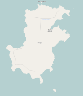
Sundy is a settlement in the northwestern part of Príncipe Island in São Tomé and Príncipe. Its population is 416. Sundy lies 5 km northwest of the island capital of Santo António. In 1822 the first cocoa plantation of the whole archipelago was established in Sundy. Several buildings of this plantation have been preserved.
São Marçal is a suburb of the city São Tomé in the nation of São Tomé and Príncipe. Its population is 2,866. It is 2.3 km southeast of the city centre of São Tomé and 1 km northwest of Pantufo.
São João da Vargem is a suburb of the city São Tomé in the nation of São Tomé and Príncipe. Its population is 1,793. It lies on the coast, 1 km northwest of the city centre of São Tomé.
Vila Clotilde is a village in Caué District on São Tomé Island in São Tomé and Príncipe. Its population is 53. Vila Clotilde lies 6.5 km west of São João dos Angolares. 3 km to its west is Pico Cão Grande, an iconic needle-shaped volcanic plug.
Correia is a settlement in the Água Grande District on São Tomé Island in São Tomé and Príncipe. Its population is 575. Located 3 km west of the city centre of São Tomé, it forms a part of the São Tomé Urban area. Before ca. 2010, it was part of the Lobata District.
Ponta Mina is a subdivision of the city São Tomé in the nation of São Tomé and Príncipe. Its population is 984. It lies directly east of the city center of São Tomé.