Richmond County, New South Wales

Last updated

Map all coordinates using: OpenStreetMap  
Download coordinates as: KML  ·  GPX
Richmond
New South Wales
Richmond NSW.PNG
Location in New South Wales
Lands administrative divisions around Richmond:
Buller Rous Pacific Ocean
Drake Richmond Pacific Ocean
Drake Clarence Pacific Ocean

Richmond County is one of the 141 Cadastral divisions of New South Wales. It lies south of the Richmond River and includes South Casino.

Richmond River river in New South Wales, Australia

The Richmond River is a river with a mature wave dominated, barrier estuary, situated in the Northern Rivers region of New South Wales, Australia.

Casino, New South Wales Town in New South Wales, Australia

Casino is a town in the Northern Rivers area of New South Wales, Australia, with a population of 10,914 people at the 2016 census. It lies on the banks of the Richmond River and is situated at the junction of the Bruxner Highway and the Summerland Way.

Richmond County was named in honour of Charles Gordon Lennox, Fifth Duke of Richmond (1791- 1860). [1]

Charles Gordon-Lennox, 5th Duke of Richmond British politician

Charles Gordon-Lennox, 5th Duke of Richmond,, styled Earl of March until 1819, was a British peer, soldier, politician, and a prominent Conservative.

Parishes within this county

A full list of parishes found within this county; their current LGA and mapping coordinates to the approximate centre of each location is as follows:

Local government in Australia

Local government in Australia is the third tier of government in Australia administered by the states and territories, which in turn are beneath the federal tier. Local government is not mentioned in the Constitution of Australia and two referenda in the 1970s and 1980s to alter the Constitution relating to local government were unsuccessful. Every state government recognises local government in their respective constitutions. Unlike Canada or the United States, there is only one level of local government in each state, with no distinction such as cities and counties.

ParishLGACoordinates
Barrawanga Richmond Valley Council 29°09′54″S153°06′04″E / 29.16500°S 153.10111°E / -29.16500; 153.10111 (Barrawanga Parish)
Bundock Richmond Valley Council 28°50′54″S152°56′04″E / 28.84833°S 152.93444°E / -28.84833; 152.93444 (Bundock Parish)
Bungawalbin Richmond Valley Council 29°04′54″S153°17′04″E / 29.08167°S 153.28444°E / -29.08167; 153.28444 (Bungawalbin Parish)
Busby Richmond Valley Council 28°59′54″S152°48′04″E / 28.99833°S 152.80111°E / -28.99833; 152.80111 (Busby Parish)
Camira Clarence Valley Council 29°15′54″S152°56′04″E / 29.26500°S 152.93444°E / -29.26500; 152.93444 (Camira Parish)
Coombell Richmond Valley Council 28°59′54″S152°58′04″E / 28.99833°S 152.96778°E / -28.99833; 152.96778 (Coombell Parish)
Darke Richmond Valley Council 29°07′54″S153°05′04″E / 29.13167°S 153.08444°E / -29.13167; 153.08444 (Darke Parish)
Dobie Clarence Valley Council 29°10′54″S152°49′04″E / 29.18167°S 152.81778°E / -29.18167; 152.81778 (Dobie Parish)
Donaldson Richmond Valley Council 29°07′54″S153°14′04″E / 29.13167°S 153.23444°E / -29.13167; 153.23444 (Donaldson Parish)
Doubleduke Richmond Valley Council 29°10′54″S153°16′04″E / 29.18167°S 153.26778°E / -29.18167; 153.26778 (Doubleduke Parish)
East Casino Richmond Valley Council 28°53′54″S153°07′04″E / 28.89833°S 153.11778°E / -28.89833; 153.11778 (East Casino Parish)
Ellangowan Richmond Valley Council 29°00′54″S153°08′04″E / 29.01500°S 153.13444°E / -29.01500; 153.13444 (Ellangowan Parish)
Esk Richmond Valley Council 29°13′54″S153°21′04″E / 29.23167°S 153.35111°E / -29.23167; 153.35111 (Esk Parish)
Evans Richmond Valley Council 29°09′54″S153°22′04″E / 29.16500°S 153.36778°E / -29.16500; 153.36778 (Evans Parish)
Gibberagee Richmond Valley Council 29°14′54″S153°09′04″E / 29.24833°S 153.15111°E / -29.24833; 153.15111 (Gibberagee Parish)
Hogarth Richmond Valley Council 29°01′54″S152°53′04″E / 29.03167°S 152.88444°E / -29.03167; 152.88444 (Hogarth Parish)
Marsh Clarence Valley Council 29°15′54″S152°51′04″E / 29.26500°S 152.85111°E / -29.26500; 152.85111 (Marsh Parish)
Mongogarie Richmond Valley Council 28°56′54″S152°50′04″E / 28.94833°S 152.83444°E / -28.94833; 152.83444 (Mongogarie Parish)
Myall Richmond Valley Council 29°17′54″S153°01′04″E / 29.29833°S 153.01778°E / -29.29833; 153.01778 (Myall Parish)
Myrtle Clarence Valley Council 29°07′54″S152°59′04″E / 29.13167°S 152.98444°E / -29.13167; 152.98444 (Myrtle Parish)
Nandabah Richmond Valley Council 29°03′54″S152°58′04″E / 29.06500°S 152.96778°E / -29.06500; 152.96778 (Nandabah Parish)
Powerpa Clarence Valley Council 29°12′54″S152°56′04″E / 29.21500°S 152.93444°E / -29.21500; 152.93444 (Powerpa Parish)
Richmond Richmond Valley Council 28°58′54″S153°04′04″E / 28.98167°S 153.06778°E / -28.98167; 153.06778 (Richmond Parish)
Riley Richmond Valley Council 29°01′54″S153°28′04″E / 29.03167°S 153.46778°E / -29.03167; 153.46778 (Riley Parish)
Shannon Richmond Valley Council 28°53′54″S152°54′04″E / 28.89833°S 152.90111°E / -28.89833; 152.90111 (Shannon Parish)
South Ballina Ballina Shire 28°55′54″S153°31′04″E / 28.93167°S 153.51778°E / -28.93167; 153.51778 (South Ballina Parish)
South Casino Richmond Valley Council 28°53′54″S153°03′04″E / 28.89833°S 153.05111°E / -28.89833; 153.05111 (South Casino Parish)
South Codrington Richmond Valley Council 28°56′54″S153°15′04″E / 28.94833°S 153.25111°E / -28.94833; 153.25111 (South Codrington Parish)
Tabbimoble Richmond Valley Council 29°15′54″S153°16′04″E / 29.26500°S 153.26778°E / -29.26500; 153.26778 (Tabbimoble Parish)
Tatham Richmond Valley Council 28°56′54″S153°11′04″E / 28.94833°S 153.18444°E / -28.94833; 153.18444 (Tatham Parish)
West Coraki Richmond Valley Council 29°01′54″S153°14′04″E / 29.03167°S 153.23444°E / -29.03167; 153.23444 (West Coraki Parish)
Whiporie Richmond Valley Council 29°14′54″S153°03′04″E / 29.24833°S 153.05111°E / -29.24833; 153.05111 (Whiporie Parish)
Wooroowoolgan Richmond Valley Council 28°52′54″S153°00′04″E / 28.88167°S 153.00111°E / -28.88167; 153.00111 (Wooroowoolgan Parish)
Woram Richmond Valley Council 28°55′54″S153°08′04″E / 28.93167°S 153.13444°E / -28.93167; 153.13444 (Woram Parish)
Wyandah Clarence Valley Council 29°07′54″S152°50′04″E / 29.13167°S 152.83444°E / -29.13167; 152.83444 (Wyandah Parish)
Wyon Richmond Valley Council 29°04′54″S152°46′04″E / 29.08167°S 152.76778°E / -29.08167; 152.76778 (Wyon Parish)

Related Research Articles

County of Cumberland, New South Wales Cadastral in New South Wales, Australia

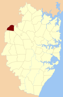
Cumberland County is a county in the State of New South Wales, Australia. Most of the Sydney metropolitan area is located within the County of Cumberland.

Mount Sugarloaf (New South Wales) mountain in New South Wales, Australia

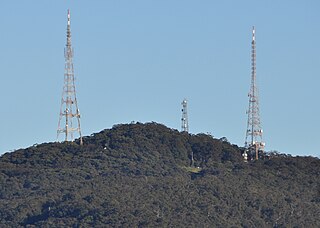
Mount Sugarloaf, also known as Great Sugar Loaf, is a mountain in the lower Hunter Region of New South Wales, Australia, overlooking the cities of Newcastle, Lake Macquarie, Cessnock and Maitland. The summit of the mountain is in the Lake Macquarie suburb of West Wallsend and access to the summit is gained via this suburb. However, the mountain itself is also part of the city of Cessnock suburbs Mulbring and Richmond Vale. It is home to television transmitters that broadcast to the lower Hunter region. On 18 and 19 July 1965, the mountain received 10 centimetres (4 in) of snow. It also snowed on the summit in the winter of 1975.

Vineyard, New South Wales Suburb of Sydney, New South Wales, Australia

Vineyard is a suburb of Sydney, in the state of New South Wales, Australia. Vineyard is located 50 kilometres west of the Sydney central business district, in the local government area of the City of Blacktown with part of it in the City of Hawkesbury. Vineyard is part of the Greater Western Sydney region. It is bounded in the west by Eastern Creek until its confluence with South Creek, a tributary of the Hawkesbury River.

Division of Richmond Australian federal electoral division

The Division of Richmond is an Australian electoral division in the state of New South Wales.

The Geographical Names Board of New South Wales, a statutory authority of the Land and Property Information division, Department of Finance and Services in the Government of New South Wales, is the official body for naming and recording details of places and geographical names in the state of New South Wales, Australia.

Rous County Cadastral in New South Wales, Australia

Rous County is one of the 141 Cadastral divisions of New South Wales. It is located at the north-east tip of the state. It is bordered on the north by the border with Queensland and on the south by the Richmond River. It contains Lismore, Byron Bay and Murwillumbah.

Mount Tomah, New South Wales Town in New South Wales, Australia

Mount Tomah is a locality and a mountain that is located in the Blue Mountains region of the state of New South Wales, Australia. The locality is known for the Blue Mountains Botanic Garden on the Bells Line of Road.

Wilsons River (New South Wales) river in New South Wales, Australia

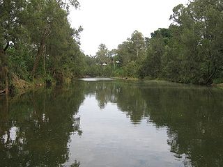
Wilsons River, a perennial river and part of the Richmond River catchment, is situated in the Northern Rivers district of New South Wales, Australia.

The Leycester Creek, a perennial stream of the Richmond River catchment, is located in Northern Rivers region in the state of New South Wales, Australia.

Esk River (New South Wales) river in New South Wales, Australia

Esk River, a perennial stream that is part of the Clarence River catchment, is located in the Northern Rivers region of New South Wales, Australia.

Evans River, an open and trained youthful wave dominated, interbarrier estuary, is located in the Northern Rivers region of New South Wales, Australia.

Back Creek (Richmond Valley, New South Wales) river in Australia

The Back Creek, a perennial stream of the Richmond River catchment, is located in Northern Rivers region in the state of New South Wales, Australia.

The Coopers Creek, a perennial stream of the Richmond River catchment, is located in Northern Rivers region in the state of New South Wales, Australia.

Sandy Creek (Richmond Valley) river in Australia

The Sandy Creek, a perennial stream of the Richmond River catchment, is located in Northern Rivers region in the state of New South Wales, Australia.

Shannon Brook river in Australia

The Shannon Brook, a perennial stream of the Richmond River catchment, is located in Northern Rivers region in the state of New South Wales, Australia.

The Eden Creek, a perennial stream of the Richmond River catchment, is located in Northern Rivers region in the state of New South Wales, Australia.

Bells Creek, an urban watercourse that is part of the Hawkesbury-Nepean catchment, is located in Greater Western Sydney, New South Wales, Australia.

Parish of Ham Common

The parish of Ham Common is one of the 57 civil parishes of the County of Cumberland, New South Wales.

References

  1. "Richmond". Geographical Names Register (GNR) of NSW. Geographical Names Board of New South Wales . Retrieved 4 August 2013. OOjs UI icon edit-ltr-progressive.svg