Richmond Nature Park

Last updated
Richmond Nature Park
"Richmond Nature Park, Richmond Nature House, March 2015.jpg".jpg
Richmond Nature House
15 Greater Vancouver Regional District British Columbia.svg
Red pog.svg
Location of Richmond Nature Park in Metro Vancouver
Location Richmond, British Columbia
Coordinates 49°10′27″N123°05′51″W / 49.1741°N 123.0975°W / 49.1741; -123.0975 Coordinates: 49°10′27″N123°05′51″W / 49.1741°N 123.0975°W / 49.1741; -123.0975
Area200 acres (81  ha)
Established1968
www.richmond.ca/parks/parks/naturepark/about.htm

The Richmond Nature Park is a bog-forest nature park located in the city of Richmond, British Columbia. The Richmond Nature Park covers 200 acres of the raised peat bog habitat that has previously covered large sections of Lulu Island. [1] The ever-changing environment of the Richmond Nature Park is also dominated by a wet, spongy land of mosses (specifically sphagnum moss), heath shrubs, and shrub-like trees. [2] The park offers four walking trails that allows visitors to walk amongst the peat bog, the forest, and the pond habitat, and the opportunity to explore the wildlife of the plants and animals within the bog-forest. [3] The Richmond Nature Park Society works on behalf of the Richmond Nature Park as a non-for-profit organization that aims in providing natural history education opportunities for visitors and residents, and through programs and events that promote the natural history of the nature park. [4]

Contents

History

1960s: In 1962, the Corporation of the Township of Richmond decided to purchase 217 acres of land from the federal Department of Transport. However, the land did not come fully into use until the year of 1968 when Will Paulik, Secretary of the Richmond Rod and Gun Club, claimed that the acres should be used as a nature region and from then on the park began to shape outdoor activities, there by establishing the land as a park. [5]

1970s: During the 1970s, the beautiful nature park had a lot of success and significant moments. For instance, their first committee meeting took place in 1971. [5] In 1972 the park was officially named and they were endowed Local Ascendancy Grants in order to help and support a number of their future projects that they had forthcoming. [5] 1976 was a significant year because the Nature House was opened to the public, and in the following year, the name of the committee was officially changed to the Richmond Nature Park Society. [5]

1980s: In the 1980s, the park's main goal was to build future ideas and to develop the park even more. There were a lot of projects that took place successfully, such as constructing a boardwalk primarily for disabled people, providing them with their own personal trail that gave them access around the pond. [5] The park's nature exhibits were also updated. Some other projects were the Bog Ecology Protection Zone, the trail guides, and time trails. [5] Through the years of 1987-1989, the park took part in technological advancement, such as their first computer and video camera for the surveillance of the park and to support their office work research for the nature house. [5]

1990s: In 1995, a winter outreach program that was directed for schools was developed, known as "Wilderness on Wheels"; however, the name of the program was later changed to "Natural Indoors". [5] In the year of 1997, the park proudly celebrated its 25th anniversary. [5]

2000s: In the year 2002, the 30th Anniversary of the City of Richmond took place. It was during this year that the park was officially appointed and identified as the Richmond Nature Park, and up to this day the park continues to flourish. [5]

Richmond Nature House

Richmond Nature Park Entrance Sign Richmond Nature Park Entrance Sign.jpg
Richmond Nature Park Entrance Sign

The Richmond Nature House in Richmond Nature Park is an interpretive centre for visitors to learn more about the park through interactive displays, games, and resources. [6] The Nature House also offers a gift shop, trail guide information, and exhibits including an active beehive and a reptile show, and a collection of live animals to educate visitors about the bog. [6] [7] Admission into the Nature House is by donation. [8]

Activities

Pond Trail Entrance Richmond Nature Park Trail.jpg
Pond Trail Entrance

Based on the many resources that is offered by the park, this allows visitors to engage in a variety of recreational and educational activities for all ages. [9] Visitors of the park can participate in hiking and walking along the four available park trails, which are also handicap and stroller accessible. [10] Birdwatching, photography, and sightseeing is also available to explore in the park's natural scenery, giving visitors the ability to encounter plants and animals in the bog, forest, and pond habitats. [9] Other amenities located in the park include the outdoor picnic area including picnic tables, washrooms, a playground area, and available parking. [10] However, food services within the park are not available.

The four main trails in the Richmond Nature Park include: Bog Forest Trail (1.8 km), Quaking Trail (1.6 km), Time trail (0.83 km) and Pond Trail (0.35 km). [10]

Ecology

Lulu Island Bog

The Lulu Island Bog which once covered a large portion of Lulu Island, is now a large remaining fragment that makes up Richmond Nature Park in the Fraser River Delta. [11] This ecosystem has been disrupted significantly by changes in drainage and reduction in size, [12] but it has kept in good shape as a raised peat bog ecosystem. [11] The development of Lulu Island Bog has led to significant changes in the bogs ecosystem over the course of the years, especially as a result of urban and agricultural use of the land. [13] Dominated by large precipitation levels, the study of this ecosystem structure is focused on the "raised or domed centre" of the bog which "causes water to drain from the centre radically outwards". [12]

The Lulu Island Bog is characterized by their temperate climate, acidic (low pH) growing conditions, and with a minimal water flow into the bog. [12] The ecology of the bog is made up of the moss known as sphagnum, which develops under an acidic, “cool, wet climatic conditions”, [8] and this moss type plays an important role in the development of a bog. [12] The development of sphagnum moss takes place in areas where the rainwater accumulates. [8] However, the plants in the bog receive very little - and sometimes even no - waterborne nutrients. [8] Due to the lack of waterborne nutrients, various resilient plants live amongst the sphagnum moss that are able to tolerate full on cool, acidic peat bog soils. [8]

One of the plant features of this bog are the carnivorous plants. These plants counteract the lack of nutrients in the soil by entrapping and consuming small insects, such as the round-leafed sundew, pitcher plants, and bladderworts. [8] [12] This bog is predominantly taken over by the "flowering plants" heath shrubs, including Labrador tea, bog rosemary, western bog laurel, bog blueberry and bog cranberry. [8] [11] As a result of the drainage impact and the drying of the bog, the Lulu Island Bog is also dominated by a few invasive species, including the European birch, highbush blueberry, American cranberry, and Scotch heather. [11] The Shore Pine tree is a tree characteristic of the bog-forest park, having the ability to tolerate the poor soils and distinguished by its "stunted or spindly appearance". [8]

Wildlife in the area

Over 100 species reside in the Richmond Nature Park. Amongst the species that live in the nature park, there are at least 13 mammals including shrews, the douglas squirrel, mice, coyotes, and black tailed deer. [12] [13] Migratory birds have also been seen to be living in the park, including a variety of owl species, hawks, eagles, woodpeckers, and many more. [14] Many of the bird species are considered to be "year-round residents", while other bird species are "found seasonally or during migration only". [14] Over the past few decades since the park has been established, the numbers and diversity of the birds have changed with time as the bog-forest has developed and expanded, but there has been especially fewer waterfowl compared to what was there during the 1970s [14]

Other species in the nature park include 2 types of garter snakes and several frog species. [13] invertebrate species are also frequently present in the park, with a great diversity of colourful butterflies and dragonflies that fly around the pond during the spring and summer seasons. [13]

Directions

The main entrance into Richmond Nature Park is through Westminster Highway, just next to No. 5 road in east Richmond. [10] The city of Richmond is located south from the city of Vancouver and nearby Vancouver International Airport. [6] The nature park is approximately a 30-minute drive from Downtown Vancouver and it is accessible via Highway 99 moving into Richmond. [6]

Exact address and directions into Richmond Nature Park: 11851 Westminster Hwy, Richmond, BC. [15]

See also

Related Research Articles

Peat Accumulation of partially decayed vegetation

Peat, sometimes known as turf, is an accumulation of partially decayed vegetation or organic matter. It is unique to natural areas called peatlands, bogs, mires, moors, or muskegs. The peatland ecosystem covers 3.7 million square kilometres and is the most efficient carbon sink on the planet, because peatland plants capture CO2 naturally released from the peat, maintaining an equilibrium. In natural peatlands, the "annual rate of biomass production is greater than the rate of decomposition", but it takes "thousands of years for peatlands to develop the deposits of 1.5 to 2.3 m [4.9 to 7.5 ft], which is the average depth of the boreal [northern] peatlands", which store around 415 gigatonnes of carbon (about 46 times 2019 global CO2 emissions). Sphagnum moss, also called peat moss, is one of the most common components in peat, although many other plants can contribute. The biological features of sphagnum mosses act to create a habitat aiding peat formation, a phenomenon termed 'habitat manipulation'. Soils consisting primarily of peat are known as histosols. Peat forms in wetland conditions, where flooding or stagnant water obstructs the flow of oxygen from the atmosphere, slowing the rate of decomposition.

Bog Type of wetland that accumulates peat due to incomplete decomposition of plant matter

A bog or bogland is a wetland that accumulates peat, a deposit of dead plant material—often mosses, and in a majority of cases, sphagnum moss. It is one of the four main types of wetlands. Other names for bogs include mire, mosses, quagmire, and muskeg; alkaline mires are called fens. A baygall is another type of bog found in the forest of the Gulf Coast states in the USA. they are often covered in heath or heather shrubs rooted in the sphagnum moss and peat. The gradual accumulation of decayed plant material in a bog functions as a carbon sink.

Fundy National Park

Fundy National Park is a national park of Canada located on the Bay of Fundy, near the village of Alma, New Brunswick. It was officially opened on 29 July 1950. The Park showcases a rugged coastline which rises up to the Canadian Highlands, the highest tides in the world and more than 25 waterfalls. The Park covers an area of 207 km2 (80 sq mi) along Goose Bay, the northwestern branch of the Bay of Fundy. When one looks across the Bay, one can see the northern Nova Scotia coast.

Risley Moss reservoir in the United Kingdom

Risley Moss is an area of peat bog situated near Birchwood in Warrington, England. It is a country park, Site of Special Scientific Interest and a Local Nature Reserve. It covers an area of 210.5 acres (85.2 ha) and is one of the last remaining fragments of the raised bogs that once covered large areas of South Lancashire and North Cheshire.

<i>Sphagnum</i>

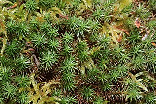
Sphagnum is a genus of approximately 380 accepted species of mosses, commonly known as "peat moss" though they are different as peat moss has a more acidic pH level. Accumulations of Sphagnum can store water, since both living and dead plants can hold large quantities of water inside their cells; plants may hold 16 to 26 times as much water as their dry weight, depending on the species. The empty cells help retain water in drier conditions.

Mer Bleue Bog

Mer Bleue Bog is a 33.43 km2 (12.91 sq mi) protected area east of Ottawa in Eastern Ontario, Canada. Its main feature is a sphagnum bog that is situated in an ancient channel of the Ottawa River and is a remarkable boreal-like ecosystem normally not found this far south. Stunted black spruce, tamarack, bog rosemary, blueberry, and cottongrass are some of the unusual species that have adapted to the acidic waters of the bog.

Burns Bog

Burns Bog is an ombrotrophic peat bog located in Delta, British Columbia, Canada. It is the largest raised peat bog and the largest undeveloped urban land mass on the West Coast of the Americas. Burns Bog was originally 4,000–4,900 hectares before development. Currently, only 3,500 hectares remain of the bog.

Cranberry Glades

Cranberry Glades — also known simply as The Glades — are a cluster of five small, boreal-type bogs in southwestern Pocahontas County, West Virginia, United States. This area, high in the Allegheny Mountains at about 3,400 feet (1,000 m), is protected as the Cranberry Glades Botanical Area, part of the Monongahela National Forest. This site is the headwaters of the Cranberry River, a popular trout stream, and is adjacent to the nearly 50,000-acre (200 km2) Cranberry Wilderness.

Pinhook Bog

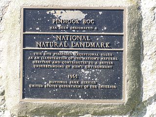
Pinhook Bog is a unique bog in Indiana that has been designated a National Natural Landmark. It is part of Indiana Dunes National Park, an area that many citizens, scientists, and politicians fought hard to preserve. Its sister bog, Volo Bog, is located nearby. The bog contains a large variety of plants, including insect eating plants, tamarack trees, stands of blueberry bushes, and floating mats of sphagnum moss. Pinhook Bog is about 580 acres (2.3 km2), a quarter of which is a floating mat of sphagnum peat moss. A "moat" separates the bog from the uplands.

Volo Bog State Natural Area

Volo Bog State Natural Area is a nature reserve in Illinois, United States, preserving Volo Bog. The bog was designated a National Natural Landmark in 1973 as the only remaining open-water quaking bog in Illinois. The site also contains woodlands, savanna, marshes, prairie restoration areas, shrubland and old fields. Maintained by the Illinois Department of Natural Resources, the site is located about a mile west of U.S. Route 12 between the towns of Volo and Fox Lake, Illinois.

Mendon Ponds Park park in New York, United States of America, United States of America

Mendon Ponds Park is a county park located southeast of Rochester, New York within the suburban towns of Mendon and Pittsford. At over 2,500 acres (10 km2), it is the largest park in Monroe County. It was designated a National Natural Landmark in 1967 in recognition of its unique glacial geology. Monroe County acquired the first 1,400 acres of the park in 1928 for $185,000 (USD).

Cors Caron Site of Special Scientific Interest in Wales

Cors Caron is a raised bog in Ceredigion, Wales. Cors is the Welsh word for "bog": the site is also known as Tregaron Bog, being near the small town of Tregaron. Cors Caron covers an area of approximately 349 hectares. Cors Caron represents the most intact surviving example of a raised bog landscape in the United Kingdom. About 44 different species groups inhabit the area including various land and aquatic plants, fish, insects, crustaceans, lichen, fungi, terrestrial mammals and birds.

<i>Aulacomnium palustre</i> species of plant

Aulacomnium palustre, the bog groove-moss or ribbed bog moss, is a moss that is nearly cosmopolitan in distribution. It occurs in North America, Hispaniola, Venezuela, Eurasia, and New Zealand. In North America, it occurs across southern arctic, subboreal, and boreal regions from Alaska and British Columbia to Greenland and Quebec. Documentation of ribbed bog moss's distribution in the contiguous United States is probably incomplete. It is reported sporadically south to Washington, Wyoming, Georgia, and Virginia.

Lime Hollow

The Lime Hollow Center for Environment and Culture is a nature preserve project in Cortland County, New York. It was founded in 1993 as the Lime Hollow Nature Center, the culmination of efforts 20 years earlier to develop a nature preserve to protect an unusual assemblage of marl ponds, a peat bog, and kame-and-kettle topography along an abandoned railroad right of way in Lime Hollow, just west of the city of Cortland.

<i>Sphagnum cuspidatum</i> species of moss

Sphagnum cuspidatum, the feathery bogmoss, toothed sphagnum, or toothed peat moss, is a peat moss found commonly in Great Britain, Norway, Sweden, the eastern coast of the United States, and in Colombia.

Forsinard Flows National Nature Reserve National nature reserve in northern Scotland

Forsinard Flows is a national nature reserve (NNR) covering much of the area surrounding Forsinard in the Highland council area of Scotland. It lies at the heart of the Flow Country, a large, rolling expanse of peatland and wetland area of Caithness and Sutherland that makes up almost 5% of the world's blanket bog. The reserve is managed by the Royal Society for the Protection of Birds (RSPB), and is designated a Category II protected area by the International Union for Conservation of Nature. Much of the NNR overlaps with the designated area of the Caithness and Sutherland Peatlands Special Protection Area and Special Area of Conservation.

<i>Polytrichum strictum</i> species of plant

Polytrichum strictum, commonly known as bog haircap moss or strict haircap, is an evergreen and perennial species of moss native to Sphagnum bogs and other moist habitats in temperate climates. It has a circumboreal distribution, and is also found in South America and Antarctica.

Kobuleti Strict Nature Reserve Protected nature area in Georgia (country)

Kobuleti Strict Nature Reserve is a protected area in Kobuleti Municipality, Adjara region of Georgia along the Black Sea coast in the northern part of the resort town Kobuleti. Kobuleti Protected Areas were established in 1998 to preserve unique wetland ecosystems recognized by the Ramsar Convention.

Moine Mhòr Area of raised bog in Argyll and Bute, Scotland

Moine Mhòr encompasses a large area of raised bog in the Kilmartin Glen area of Argyll and Bute, Scotland. As well as raised bog there are areas of saltmarsh, brackish grassland, alder carr, fen and woodland, and the variety of habitats at Moine Mhòr provide important habitats for a variety of animal and plant species. The area was declared a national nature reserve (NNR) in 1987, and is now owned and managed by NatureScot. According to NatureScot lowland raised bogs like Moine Mhòr are some of the rarest and most threatened natural wildlife habitats in Europe, due to removal of peat, afforestation and reclamation of farmland.

References

  1. "Self Guided Activity Suggestions". Faculty of Forestry: Cons 101. University of British Columbia. Retrieved 11 March 2015.
  2. "Nature Park Brochure" (PDF). City of Richmond. City of Richmond. Retrieved 11 March 2015.
  3. "About the Nature Park". City of Richmond. City of Richmond. Retrieved 11 March 2015.
  4. "Richmond Nature Park Society". Richmond Nature Park Society. Retrieved 11 March 2015.
  5. 1 2 3 4 5 6 7 8 9 10 "A History of the Richmond Nature Park". Richmond Nature Park Society. Retrieved 11 March 2015.
  6. 1 2 3 4 "Richmond Nature Park". Info Vancouver. Retrieved 11 March 2015.
  7. "Richmond Nature Park". Venture Vancouver. Retrieved 11 March 2015.
  8. 1 2 3 4 5 6 7 8 "Bog Ecology" (PDF). City of Richmond. City of Richmond. Retrieved 11 March 2015.
  9. 1 2 "Richmond Nature Park". Tourism Richmond. Retrieved 15 April 2015.
  10. 1 2 3 4 "Richmond Nature Park - Richmond, BC". VancouverBCEH. Retrieved 11 March 2015.
  11. 1 2 3 4 "Lulu Island Bog". Biodiversity of Richmond, British Columbia. University of British Columbia. Retrieved 11 March 2015.
  12. 1 2 3 4 5 6 Klinkenberg, Davis; Klinkenberg, Neil; Klinkenberg, Rose. "A Biophysical Inventory and Evaluation of the Lulu Island Bog, Richmond, British Columbia" (PDF). Richmond Nature Park Society. Retrieved 10 March 2015.
  13. 1 2 3 4 "Nature Park: Plants, Animals, and Ecology". City of Richmond. Retrieved 10 March 2015.
  14. 1 2 3 "Birds Brochure" (PDF). City of Richmond. Retrieved 10 March 2015.
  15. "Directions". Richmond Nature Park Society. Retrieved 11 March 2015.