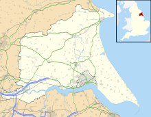
Flamborough Head is a promontory, 8 miles (13 km) long on the Yorkshire coast of England, between the Filey and Bridlington bays of the North Sea. It is a chalk headland, with sheer white cliffs. The cliff top has two standing lighthouse towers, the oldest dating from 1669 and Flamborough Head Lighthouse built in 1806. The older lighthouse was designated a Grade II* listed building in 1952 and is now recorded in the National Heritage List for England, maintained by Historic England. The cliffs provide nesting sites for many thousands of seabirds, and are of international significance for their geology.

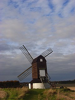
Pitstone is a village and civil parish in the Aylesbury Vale district of Buckinghamshire, England. It is at the foot of the central range of the Chiltern Hills, centred 6 miles (9.7 km) east of Aylesbury and 5 miles (8.0 km) south of Leighton Buzzard. It directly adjoins the village of Ivinghoe, and the two villages share some facilities.

The Yorkshire Wildlife Trust is a wildlife trust that covers the Yorkshire and the Humber region of England. When it was founded, it covered the traditional county of Yorkshire, England, but under the 1974 county boundary changes, some of the trust's boundaries were amended to reflect those changes. The Trust is part of the UK-wide partnership of 46 Wildlife Trusts. It was formed in 1946, as the Yorkshire Naturalists’ Trust, essentially to preserve its first nature reserve Askham Bog on the outskirts of York. It now manages more than ninety reserves across the county, including some of the best wildlife sites in the UK. These nature reserves cover the diversity of Yorkshire's landscape, from woodland to grassland, wetland and moorland, fen and bog, and river and coast. One of the flagship reserves is Potteric Carr, a mixed wetland habitat to the south of Doncaster.

West Beck is the common name given to the upper section of the old River Hull, as it rises in the foothills of the Yorkshire Wolds. After reaching Frodingham Beck at Emmotland, it becomes called the River Hull. It is noteworthy for being the most northerly chalk stream in England. It provides fly fishing for wild brown trout and grayling.

Melton is a small village in the civil parish of Welton, East Riding of Yorkshire, England. It is situated about 8 miles (13 km) west of Kingston upon Hull city centre near to the Humber Estuary and about 0.6 miles (1 km) east of the village of Welton with which it is nearly contiguous.

Totternhoe Stone is a relatively hard chalk outcropping in the middle of the Lower Chalk in the Chiltern Hills in Hertfordshire, Buckinghamshire, Bedfordshire and Cambridgeshire, England. Geologically, it is located in the upper part of the Cenomanian stage of the Cretaceous.

Barnsley Warren is a 61.3-hectare (151-acre) biological Site of Special Scientific Interest in Gloucestershire, notified in 1954 and renotified in 1984. The site is also a Nature Conservation Review site. It lies in a steep-sided dry valley, east of the A429, northeast of Cirencester in the Cotswolds. The site is listed in the 'Cotswold District' Local Plan 2001-2011 as a Key Wildlife Site (KWS).

Cherry Hinton Pit is a 12.8 hectare biological Site of Special Scientific Interest (SSSI) on the south-eastern outskirts of Cambridge. The site consists of East Pit and most of the smaller West Pit. East Pit is part of the Limekiln Close and East Pit Local Nature Reserve, which is managed by the Wildlife Trust for Bedfordshire, Cambridgeshire and Northamptonshire under the name Cherry Hinton Chalk Pits. West Pit is a separate Local Nature Reserve (LNR).

Herts and Middlesex Wildlife Trust manages over 40 nature reserves covering nearly 810 hectares north of London, in Hertfordshire and the former county of Middlesex, which is now divided between the London boroughs of Barnet, Enfield, Harrow and Hillingdon. It has over 21,000 members, and is one of 46 Wildlife Trusts across the UK. It is a Registered Charity, with its Registered Office in St Albans, and had an income in the year to 31 March 2014 of over £1.5 million.

Beckhead Plantation is a Site of Special Scientific Interest (SSSI) and nature reserve in the East Riding of Yorkshire, England. It is located close to the village of Great Givendale on the Yorkshire Wolds. The site, which was designated a SSSI in 1968, is managed as a nature reserve by the Yorkshire Wildlife Trust. It lies on chalk land in Given Dale. The site is important because it demonstrates many of the characteristic features of a northern ash woodland on chalk. The tree canopy is dominated by ash with some wych elm, field maple and rowan while the understorey contains shrub species including hazel, guelder rose, elder, gooseberry and fly honeysuckle.

Bull Cross, The Frith and Juniper Hill is a 42.33-hectare (104.6-acre) biological and geological Site of Special Scientific Interest in Gloucestershire, notified in 1954. The site is listed in the ‘Stroud District’ Local Plan, adopted November 2005, Appendix 6 as an SSSI and Regionally Important Geological Site (RIGS).

Hill End Pit is a 0.7 hectare a nature reserve on the site of a former chalk pit, in St Paul's Walden in North Hertfordshire. It was formerly managed by the Herts and Middlesex Wildlife Trust (HMWT). In February 2016 HMWT announced that three sites, Barkway Chalk Pit, Hill End Pit and Pryor's Wood, which HMWT managed on behalf of their owner, North Hertfordshire District Council, were to return to Council management as the Trust was no longer able to meet the cost. It has the largest colony of Azeca goodalli snails in Hertfordshire. Plants include viper's bugloss, cowslip and marjoram, there are butterflies such as common blue and gatekeeper, and many birds including woodpeckers.

Totternhoe nature reserve is managed by the Wildlife Trust for Bedfordshire, Cambridgeshire and Northamptonshire (WTBCN). The 31 hectare site is in Totternhoe in Bedfordshire, and it includes parts of three Sites of Special Scientific Interest (SSSIs). Totternhoe Knolls is a biological SSSI owned by Central Bedfordshire Council and leased to the National Trust. Most of it is managed jointly by the National Trust and the WTBCN, excluding Totternhoe Castle, the earthworks of a Norman motte-and-bailey castle which is part of the SSSI but not of WTBCN's nature reserve. Totternhoe nature reserve also includes the geological SSSI, Totternhoe Stone Pit, which is not open to the public, and other areas owned by WTBCN, including part of Totternhoe Chalk Quarry, another biological SSSI.

The Hudson Way is a 10 miles (16 km) walking and cycling route in the East Riding of Yorkshire, England. The route follows a disused railway line between the market towns of Market Weighton and Beverley.


