Rimutaka Tunnel

Last updated

Rimutaka Tunnel
Rimutaka Tunnel Opening Ceremony, 3 November 1955 (10469156015).jpg
Overview
Line Wairarapa Line
Location Remutaka Range, Wellington, New Zealand
Coordinates West portal: 41°6′28.36″S175°8′22.18″E / 41.1078778°S 175.1394944°E / -41.1078778; 175.1394944
East portal: 41°7′57.8″S175°14′23.31″E / 41.132722°S 175.2398083°E / -41.132722; 175.2398083
StatusOpen
StartMaymorn, Upper Hutt
EndRimutaka Loop
Operation
Opened3 November 1955
Owner New Zealand Railways Corporation
Operator KiwiRail (freight), Transdev Wellington (passenger)
CharacterPassenger/freight
Technical
Line length8.93025 kilometres (5.5 mi)
No. of tracks Single
Track gauge 3 ft 6 in (1,067 mm)
Electrified Provided for 1500 V DC but not installed
Operating speed100 km/h (62 mph)

The Rimutaka Tunnel (officially Tunnel 2, Wairarapa Line) is a railway tunnel through New Zealand's Remutaka Range, between Maymorn, near Upper Hutt, and Featherston, on the Wairarapa Line.

Contents

The tunnel, which was opened to traffic on 3 November 1955, is 8.93025 kilometres (5.54900 mi) long. It was the longest tunnel in New Zealand, superseding the Otira Tunnel in the South Island until the completion of the Kaimai Tunnel 9.025 kilometres (5.608 mi) near Tauranga in 1978. Rimutaka remains the longest tunnel in New Zealand with scheduled passenger trains.

History

The tunnel was built as part of a deviation to replace the costly Rimutaka Incline and its Fell engines.

Background

The original route between Upper Hutt and Featherston was often the subject of criticism, even before it was built. In 1898 J. H. Dobson completed several surveys on behalf of the Public Works Department into possible alternatives. Conclusions reached in 1899 as a result of these surveys did little more than confirm previous opinions. One promising possibility was a 5-mile (8.0 km) tunnel between Mangaroa and Cross Creek, which received so much attention that it nearly became the much-sought deviation. By 1900, however, it was realised that the cost of constructing such a tunnel could not be contemplated at that time.

It was not until the 1920s that significant campaigning for a replacement again prevailed on the government. In 1921-22 a feasibility study was conducted, including distances and estimated costs. Several routes were considered, including variations on previous ideas, but nothing more was done at the time; although a deviation of about 5 miles 48 chain (9 km) as the Wellington-Napier Line (Rimutaka Deviation) running generally to the south-eastward of the existing line was authorised by the Railways Authorisation Act, 1924. [1]

The new Labour government of 1936 announced its intention to proceed with the Mangaroa to Cross Creek tunnel. Detailed surveys were completed in 1938/1939, but the project was again postponed due to World War II.

After World War II it became a matter of urgency to consider a replacement. The H class locomotives were showing their age, the Incline was in bad shape, and maintenance costs were increasing. Between September 1945 and July 1947 four options were considered. It was accepted that no contour line could be the solution and that a tunnel under the Rimutaka Ranges was the only satisfactory answer. The adopted route was the shortest route, a tunnel between Mangaroa and Lucena’s Creek gully.

Construction

Construction commenced in 1948 when the Public Works Department started the tunnel with bores of 1,054 feet (321 m) at the western end and 820 feet (250 m) at the eastern end. A contract for completing the tunnel was let to a consortium of Morrison Knudsen and Downer (MKD) on 7 May 1951. The work commenced at the west end in July 1951 and at the east end in August. The contract was expected to be completed in four years, but the headings met on 20 April 1954 with the concrete lining finished a month later. The tunnel was partly built using full face operation rather than the traditional heading and bench excavation. Much of the fill removed on the West (Hutt) side was used for the Maymorn station site. [2]

About 600 people were employed by MKD (about 300 to 400 at any one time), plus 14 MOW engineers and inspectors. Most were single men and lived in huts at camps or a bunkhouse at the Mangaroa or Featherston portals, which had cookhouses and mess halls plus 20 houses each for married staff. There were three fatalities during tunnelling. [3]

New Zealand Railways took possession of the tunnel on 1 February 1955, which also included approach formations and bridge piers, at which time track laying commenced. [4] By October 1955 the signalling and centralised traffic control equipment had been installed and all the track was laid, except for a short section near Upper Hutt where the old line crossed the new line at a higher level. All traffic on the Upper Hutt to Featherston section was suspended after the arrival of the Carterton Show Day excursion train at Upper Hutt on the evening of 29 October. Over the next three days the old formation was removed, the cutting for the new formation completed and the remainder of the track laid. On 3 November 1955, the new line was opened and two special trains travelled from Wellington to Speedy’s Crossing to the inauguration ceremony. [5]

Design

The deviation's ruling grade is 1 in 70, compensated for curvature. The tightest curve is 400 metres (20 chain) radius. The tunnel rises at 1 in 400 from the western portal to the highest point on the deviation, roughly halfway through the tunnel, and then descends to the eastern portal at 1 in 180. [6] It has an internal height of 5.18 metres (17 ft) and a width of 4.68 metres (15 feet 4 inches); it is lined with concrete with a minimum thickness of 38 cm (15 inches) inside the face of the excavation. When the tunnel holed through on 20 April 1954 the surveying error was found to be only 44.5 mm (1.75 inches). [7] The tunnel was planned to reduce the distance between Upper Hutt and Featherston from 24 mi 65 ch (39.9 km) to 15 mi 32 ch (24.8 km). [8]

After its completion, a 2.74 metre (9 ft) diameter vertical ventilation shaft was driven up from a point almost halfway through the tunnel. It reaches the surface beside the Remutaka Rail Trail near the former route's Pakuratahi Tunnel. The 117 metre (380 ft) high shaft was constructed after tests showed that the tunnel would not generate enough natural ventilation if diesel traction was used through the tunnel. Originally it had been envisaged that electric traction would be used by extending the 1500-volt DC overhead electrification beyond Upper Hutt to either Featherston or Masterton, but economic studies favoured diesel traction. [9]

The new formation included two crossing loops; at the new Maymorn Railway Station (116 wagons) and the Rimutaka Loop (95 wagons) at the eastern portal of the tunnel. There are four bridges including a five-span 91 metres (300 ft) bridge across the Mangaroa River, and a tunnel and two underpasses near Maoribank. [10]

The Maoribank Tunnel is 555 metres (1,821 ft) long; it was tendered separately in 1953 and constructed by MKD, work started in October 1953 and was completed in December 1954. [11] On the eastern side where two short tunnels (220 metres (11 chain) and 180 metres (9 chain)) had been proposed through a spur, it was cheaper to lengthen the line by 140 metres (7 chain) and have open cuttings. [12]

The construction of the Rimutaka Tunnel consumed:

  • Gelignite: 299,258 kg (659,750 lbs),
  • Detonators: 327,850,
  • Diesel fuel: 3,182,264 litres (700,000 imp. gallons),
  • Cement: 26,163 tonnes (25,750 tons),
  • Aggregate: 87,837 metres3 (114,886 cu. yd), and
  • Timber: 15,820 metres3 (6,703,533 super feet). [13]

Operation

Traction

The first locomotives to work through the tunnel were the 560 kW DG class - the tunnel was too long for steam locomotives, making the Wairarapa Line the first fully dieselised line in New Zealand. Today, DC, DFT and DX class locomotives run the route.

There have been proposals to electrify the tunnel and the Wairarapa line as far north as Masterton as an extension of the Wellington suburban electrification. [14] The tunnel was designed to enable catenary to be installed but this has not happened, and the catenary finishes just north of Upper Hutt station. In 2007, Greater Wellington Regional Council rejected a call to electrify the tunnel, on the basis that patronage did not justify the expenditure, and that the tunnel would "have to be made bigger." [14]

Services

Passenger

Transdev Wellington operates passenger services named the Wairarapa Connection between Wellington and Masterton via the tunnel five times a day each way Monday to Thursday, six on Friday, and twice a day each way on Saturday, Sunday, and public holidays. Excursion trains also go through the tunnel, such as railway enthusiast specials and trains to the Toast Martinborough festival.

Steam-hauled excursions require diesel locomotives to provide motive power through the tunnel due to the danger from smoke in the tunnel's lengthy and confined conditions.

From 2014 diesel locomotives hauling passenger trains in long tunnels were required to have fire suppression equipment, following the Pike River Mine disaster inquiry. Initially, DC class locomotives were used for the Wairarapa Connection, then from 2015, the DFB class was used.

Freight

The tunnel is used for freight from the Wairarapa to Wellington, notably logs from local pine forests and wood products from the Juken New Zealand Ltd timber mill at Waingawa, just south of Masterton.

Related Research Articles

Upper Hutt City in Wellington, New Zealand

Upper Hutt is a city in the Wellington Region of the North Island of New Zealand, and one of the four cities that constitute the Wellington metropolitan area.

Rimutaka Incline

The Rimutaka Incline was a 3-mile-long (4.8 km), 3 ft 6 in gauge railway line on an average grade of 1-in-15 using the Fell system between Summit and Cross Creek stations on the Wairarapa side of the original Wairarapa Line in the Wairarapa district of New Zealand. The term "Rimutaka Incline" is sometimes used incorrectly to refer to other parts or all of the closed and deviated section of the Wairarapa Line between Upper Hutt and Speedy's Crossing, near Featherston. The incline formation is now part of the Remutaka Rail Trail.

Remutaka Range Mountain range

The Remutaka Range is the southernmost range of a mountain chain in the lower North Island of New Zealand. The chain continues north into the Tararua, then Ruahine Ranges, running parallel with the east coast between Wellington and East Cape.

Public transport in the Wellington Region

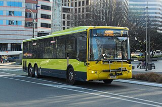
The Wellington Region has a well developed public transport system, the most used in New Zealand. It consists of electric and diesel buses, commuter trains, ferries and a funicular. It also included trams until 1964 and trolleybuses until 2017.

Wairarapa Line

The Wairarapa Line is a secondary railway line in the south-east of the North Island of New Zealand. The line runs for 172 kilometres (107 mi), connects the capital city Wellington with the Palmerston North - Gisborne Line at Woodville, via Lower Hutt, Upper Hutt and Masterton.

Wairarapa Connection

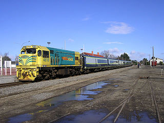
The Wairarapa Connection is a New Zealand interurban commuter rail service along the Wairarapa Line between Masterton, the largest town in the Wairarapa, and Wellington. It is operated by Wellington suburban operator Transdev under contract from the Greater Wellington Regional Council. It is a diesel-hauled carriage service, introduced by the New Zealand Railways Department in 1964 after passenger demand between Masterton to Wellington exceeded the capacity of the diesel railcars then used.

Maymorn, a rural area of Upper Hutt city in the Wellington region of New Zealand, consists of Rural Hill and Rural Valley Floor zones. The New Zealand census treats Maymorn as part of Te Mārua for statistical purposes. The usual resident 2013 population of the Te Mārua area was 1,152. The area has a tranquil setting and consists of lifestyle blocks and farms surrounded by hills that are usually covered with a dusting of snow in the winter.

Hutt Valley Line

The Hutt Valley Line is the electrified train service operated by Transdev Wellington on behalf of Metlink on the section of the Wairarapa Line railway between Wellington and Upper Hutt, New Zealand.

Maymorn railway station

Maymorn railway station is a twin platform, rural request stop railway station serving the small settlement of Maymorn on the Maymorn Plateau, east of Upper Hutt, in New Zealand’s North Island. It is served by the Wairarapa Connection, and sees five services each way Monday to Thursday, six on Friday and two on Saturday and Sunday.

The Rimutaka Incline Railway Heritage Trust is a non-profit, charitable trust in New Zealand that was established in 2003 with the objective of reinstating an operating heritage railway over the Remutaka Ranges using the original route of the Wairarapa Line between Maymorn and Featherston, including the world-famous Rimutaka Incline.

Upper Hutt railway station

Upper Hutt railway station is a suburban railway station serving central Upper Hutt, New Zealand. The station is on the Wairarapa Line, 32.4 km (20.1 mi) north of Wellington, and is served by Transdev Wellington on behalf of the Greater Wellington Regional Council. The station is the northern terminus for the electrified Hutt Valley Line to and from Wellington. The diesel-hauled Wairarapa Connection stops at Upper Hutt on its route between Wellington and Masterton.

Waterloo railway station, Lower Hutt Railway station

Waterloo railway station is a dual-platform suburban railway station located in Lower Hutt, New Zealand, and serving immediately the suburbs of Waterloo, Lower Hutt Central and Woburn. The station stands on the Hutt Valley section of the Wairarapa Line, 15.5 km (9.6 mi) north of Wellington. Trains stopping at Waterloo run to Wellington, Taita, Upper Hutt and Masterton, as well as to points in between. Waterloo serves as a major bus-rail interchange, connecting buses to and from central Lower Hutt, Naenae and Wainuiomata with trains to and from Wellington.

Kaitoke railway station

Kaitoke railway station was a single-platform rural railway station on the Wairarapa Line between Upper Hutt and Featherston in the Wellington region of New Zealand's North Island. Initially it was the railhead of the Wairarapa Line, at a point where the railway met the main road between Upper Hutt and the Wairarapa. Later it was a point at which locomotives were changed, steam engines were watered, trains could cross, and passengers could make use of the refreshment room.

Mangaroa railway station

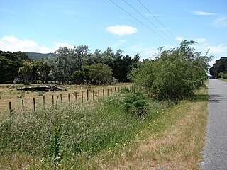
Mangaroa railway station was a single-platform rural railway station on the Wairarapa Line between Upper Hutt and Featherston in the Wellington region of New Zealand’s North Island, on the section that was replaced by the Rimutaka Tunnel deviation in 1955. It served the small rural settlement of Mangaroa, in the Mangaroa Valley, east of Upper Hutt.

Summit railway station, Wellington Region

Summit railway station was at the summit of the Wairarapa Line over the Rimutaka Ranges in the Wellington region of New Zealand’s North Island and was where trains were marshalled for a descent down the Rimutaka Incline or for Fell locomotives to be extricated from a train that had ascended the Incline. The station was between Kaitoke and Cross Creek stations on the Wairarapa Line. The station was bypassed when the Rimutaka Tunnel was opened.

Pigeon Bush railway station

Pigeon Bush railway station was a single platform, rural railway station in an area of the South Wairarapa district known as Pigeon Bush, about 6 kilometres (3.7 mi) south-west of Featherston, in New Zealand's North Island. The station was between Featherston and Cross Creek stations on the Wairarapa Line. The station was bypassed when the Rimutaka Tunnel was opened.

Cross Creek railway station

Cross Creek railway station was the base of operations for the Rimutaka Incline, a Fell railway over the Remutaka Ranges, and part of the original Wairarapa Line between Upper Hutt and Featherston in the Wellington region of New Zealand's North Island. The station was between Pigeon Bush and Summit stations on the Wairarapa Line. The station was bypassed when the Rimutaka Tunnel was opened.

Remutaka Rail Trail

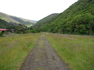
The Remutaka Rail Trail is a walking and cycling track in the North Island of New Zealand. It runs between Maymorn and Cross Creek, and follows 22 kilometres (14 mi) of the original route of the Wairarapa Line over the Remutaka Range between the Mangaroa Valley and the Wairarapa, including the world-famous Rimutaka Incline. Parts of the trail are also used by vehicles both from the regional council and from forestry companies with tree plantations in the area; members of the public have limited vehicular access from the Kaitoke end to a car park, go-kart track and gun range. Access is also granted by permission to horse riders. Touring coaches have been used upon occasion to convey tourists and other visitors to various parts of the route.

Maoribank is a suburb of Upper Hutt, located 2–3 km east-northeast of the city centre. It was predominantly developed between 1950-1970 and had a population of just less than 1000 at the 2013 Census.

Railway electrification in New Zealand

Railway electrification in New Zealand consists of three separate electric systems, all in the North Island. Electrification was initially adopted by the New Zealand Railways for long tunnels; the Otira Tunnel, the Lyttelton Rail Tunnel and the two Tawa Tunnels of the Tawa Flat Deviation. Electrification of Wellington suburban services started with the Johnsonville Line and Kapiti Line out of Wellington from the 1930s. Auckland suburban services were electrified in 2014–2015. Electrification of long-distance services on the North Island Main Trunk (NIMT) dates from 1986. New long tunnels, for example the Rimutaka Tunnel and the Kaimai Tunnel, were operated by diesels, and the Otira and Lyttelton Tunnels have converted to diesel operation.

References

  1. "Railways Authorisation Act, 1924". New Zealand Law online.
  2. Swainson 1995, pp. 27,62-64.
  3. Swainson 1995, pp. 134,135,.
  4. NZR Takes over Tunnel Railway Transportation May 1955 page 40
  5. 77-year old Traffic Problem Banished With Opening of 5.46-mile Tunnel Railway Transportation December 1955 page 4
  6. Keller, 1954; p. 404
  7. Keller, 1954; p. 413
  8. "Appendix to the Journals of the House of Representatives — 1948 Session I — D-01 MINISTRY OF WORKS STATEMENT (BY THE HON. R. SEMPLE, MINISTER OF WORKS)". atojs.natlib.govt.nz. Retrieved 14 May 2018.
  9. Cameron 1976, pp. 308,309.
  10. Cameron 1976, p. 316f.
  11. Swainson 1995, pp. 110-112,127.
  12. Keller 1954, pp. 404-410.
  13. Keller, 1954; p. 416
  14. 1 2 "Wairarapa rail won't go electric". Wairarapa Times-Age. 12 July 2007. Retrieved 21 December 2011.

Further reading