Rinsumageast

Last updated
Rinsumageast
Rinsumageest
Village
Alexanderkerk van Rinsumageest.jpg
Saint Alexander’s church
Rinsumageast vlag.svg
Rinsumageast wapen.svg
Map NL Dantumadiel Rinsumageast.png
Location in Dantumadiel municipality
2010-NL-P02-Fryslan-positiekaart-gemnamen.jpg
Red pog.svg
Rinsumageast
Location in the Netherlands
Netherlands location map.svg
Red pog.svg
Rinsumageast
Rinsumageast (Netherlands)
Coordinates: Coordinates: 53°17′48″N5°56′51″E / 53.29667°N 5.94750°E / 53.29667; 5.94750
Country Flag of the Netherlands.svg Netherlands
Province Frisian flag.svg Friesland
Municipality Flag of Dantumadeel.svg Dantumadiel
Population
 (2017)
  Total965
Time zone UTC+1 (CET)
  Summer (DST) UTC+2 (CEST)
Website Official

Rinsumageast (Dutch : Rinsumageest [1] [2] ) is a village in the Dantumadiel municipality of Friesland, the Netherlands. It had a population of around 965 in 2017. [3]

Contents

The village is locally called De Geest [4] (Dutch) or De Geast [5] (West Frisian).

History

The modern village of Rinsumageast has its origins on the sand ridge in the northwestern edge of the Dokkumer Wouden. It is possible that the place originated on a artificial dwelling mound, an so called terp in the clay soil area within the village area, there were several terpen there and in the vicinity. [4] In a 12th century copy of documents from 825 and 944, the place Ringesheim was indicated in this area. In the 12th century there is place that was called Rynsegum. [2] Around 1100 a church was built on the sand ridge, [6] about 500 meters from two terpen. [4]

A village developed on the sand ridge, which is referred to in the 13th century as Ringesimagast. In 1333 it is mentioned as Ghaest, in 1421 as Renismagaest and in 1533 as Rensymagheest. [2] In the 16th and 17th century, the spelling Rensymageest is most commonly used, also in West Frisian. [5] The village is then the main place of the grietenij Dantumadiel. There were also four major states, the Juwsmastate, Melkamastate, Tjaardastate and the Eysingastate. The stately home of the Juwsmastate was the first of these states to be demolished. The Tjaardastate was a castle and was the last to be demolished, in 1834. This castle stood just south of the village church. [6]

Just north of the village there was a terp on top of the monastery Klaarkamp. This monastery grew into one of the largest in Friesland. [6] From 1593 to 1880, Rinsumageast was the capital of the Grietenij and then the municipality of Dantumadiel with the town hall situated in the village. [4] In 1881 Murmerwoude became the administrative center with a new town hall there. The village of Rinsumageast developed from the 17th century along the water De Moark and the almost parallel boat / barge-canal. [6]

Since the 19th century the place has been called Rinsumageest, [5] until 2009 it was also the official name of the village. In modern West Frisian it is Rinsumageast. In 2008 the municipality Dantumadiel decided that it was going the replace all the official Dutch names within the municipality with the West Frisian names, [7] meaning that Rinsumageast was from 2009 the official name for the village.

Notable buildings

Related Research Articles

Dantumadiel Municipality in Friesland, Netherlands

Dantumadiel is a municipality in the province of Friesland in the Netherlands. Dantumadiel is a rural municipality characterized by agriculture.

Damwâld Village in Friesland, Netherlands

Damwâld is a village in the Dantumadiel municipality of Friesland, in the Netherlands. In 2020 it had 5630 citizens. This number of citizens makes Damwâld the largest village in the municipality of Dantumadiel.

<i>Terp</i> Raised ground to provide a refuge from flooding

A terp, also known as a wierde, woerd, warf, warft, werf, werve, wurt or værft, is an artificial dwelling mound found on the North European Plain that has been created to provide safe ground during storm surges, high tides and sea or river flooding. The various terms used reflect the regional dialects of the North European region. In English sources, terp appears to be by far the most common term used.

Anjum Village in Friesland, Netherlands

Anjum is a village in the Dutch province of Friesland. It is located in the municipality Noardeast-Fryslân and had, as of January 2017, a population of 1136.

Aalsum, Friesland Village in Friesland, Netherlands

Aalsum is a village in the Dutch province of Friesland. It is located in the municipality Noardeast-Fryslân, about 1 km north of Dokkum. It had a population of around 125 in January 2017

Wâlterswâld Village in Friesland, Netherlands

Wâlterswâld is a village in Dantumadiel municipality, Friesland, the Netherlands. The village had a population of approximately 920 in 2017.

Burdaard Village in Friesland, Netherlands

Burdaard is a village in Noardeast-Fryslân in the province of Friesland, the Netherlands. It had a population of around 1,173 in January 2017. Before 2019, the village was part of the Ferwerderadiel municipality.

Niawier Village in Friesland, Netherlands

Niawier is a village in Noardeast-Fryslân in the province of Friesland, the Netherlands. It had a population of around 366 in January 2017. Before 2019, the village was part of the Dongeradeel municipality.

Sibrandahûs Village in Friesland, Netherlands

Sibrandahûs is a small village in the Dantumadiel municipality of Friesland, the Netherlands. It had a population of around 40 in 2017. It is located just west of Dokkum.

De Falom Village in Friesland, Netherlands

De Falom is a village in the Dantumadiel municipality of Friesland, the Netherlands. It had a population of 235 in 2017.

Readtsjerk Village in Friesland, Netherlands

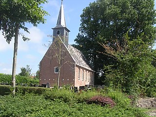
Readtsjerk is a village in the Dantumadiel municipality of Friesland, the Netherlands. It had a population of around 185 in 2017.

Broeksterwâld Village in Friesland, Netherlands

Broeksterwâld is a village in the Dantumadiel municipality of Friesland, in the Netherlands. In 2017, it had a population of around 1,100.

Feanwâlden Village in Friesland, Netherlands

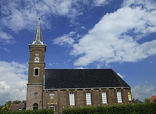
Feanwâlden is a village in the Dantumadiel municipality of Friesland, the Netherlands. It had a population of around 3,430 in 2014.

De Westereen Village in Friesland, Netherlands

De Westereen, Dutch: Zwaagwesteinde) is a village in the Dantumadiel municipality of Friesland, the Netherlands. It had a population of around 5,000 in 2017.

Driezum Village in Friesland, Netherlands

Driezum is a village in the Dantumadiel municipality of Friesland, the Netherlands. It had a population of around 850 in 2017.

Menaam Village in Friesland, Netherlands

Menaam is a village in Waadhoeke municipality in the province of Friesland, the Netherlands. It had a population of around 2,609 citizens in January 2017. Before 2018, the village was part of the Menameradiel municipality.

Feanwâldsterwâl Village in Friesland, Netherlands

Feanwâldsterwâl is a village in the Dantumadiel and Tytsjerksteradiel municipality's of Friesland, the Netherlands. it had a population of around 420 in 2021, however Feanwâldsterwâl is not a statistical entity, and the population count is only an estimation.

Almenum Village in Friesland, Netherlands

Almenum is a historic locality in the northern Netherlands, near Midlum, Friesland the site of the first Christian church in Friesland. Saint Boniface set up a local church in the locality in 754. The location of the church is on the Terp of Almenum, a mound of earth about five meters high. Almenum is named after the place where someone called "Allaman" lived. The -um suffix is derived from the West Frisian word "hiem" meaning "home". An alternative explanation for the name of the locality is that it originally meant common lands for grazing cattle. In Icelandic this kind of land still uses the term "almenningurheim".

Eastwâld is a hamlet in the municipality of Dantumadiel in the province of Friesland, the Netherlands.

Kûkherne is a hamlet in the municipalities of Achtkarspelen, Dantumadiel and Tytsjerksteradiel, in the province of Friesland, the Netherlands.

References

  1. Taalunie (2019). "Friese namen" (in Dutch). Retrieved 18 November 2019.
  2. 1 2 3 G. van Berkel & K. Samplonius (2018). "Nederlandse plaatsnamen verklaard" (in Dutch). Retrieved 14 April 2021.
  3. Kerncijfers wijken en buurten 2017 - CBS
  4. 1 2 3 4 dbnl.org (1984). "Noordelijk Oostergo. Dantumadeel - Herma M. van den Berg" (in Dutch). Retrieved 28 April 2021.
  5. 1 2 3 Gildemacher, Karel F. (2007). Friese plaatsnamen: alle steden, dorpen en gehuchten. Leeuwarden, Friese Pers/Noordboek (in Dutch)
  6. 1 2 3 4 frieslandwonderland.nl. "Stichting Fryslâns Ferline; NoordBoek - Peter Karstkarel" (in Dutch). Retrieved 28 April 2021.
  7. "Archived copy". Archived from the original on 2018-09-08. Retrieved 2021-04-14.{{cite web}}: CS1 maint: archived copy as title (link)