Cumberland is a historic county of North West England that had an administrative function from the 12th century until 1974. It is bordered by the historic counties of Northumberland to the northeast, County Durham to the east, Westmorland to the southeast, Lancashire to the south, and the Scottish counties of Dumfriesshire and Roxburghshire to the north. It formed an administrative county from 1889 to 1974 and now forms part of Cumbria.

Penrith is a market town and civil parish in the county of Cumbria, England, less than 3 miles (5 km) outside the Lake District National Park. It had a population of 15,181 at the 2011 Census. Historically in Cumberland, Penrith's local authority is currently Eden District Council, which is based in the town, as were the defunct Penrith Urban and Rural District councils. From 1974 to 2015, it was an unparished area with no local council, but a civil parish was reintroduced as Penrith Town Council and first elected on 7 May 2015.

The River Lune is a river 53 miles (85 km) in length in Cumbria and Lancashire, England.
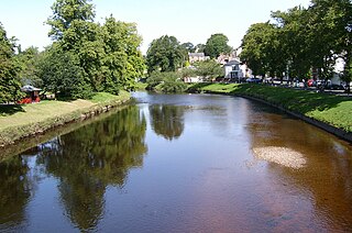
The River Eden is a river that flows through the Eden District of Cumbria, England, on its way to the Solway Firth.

Great Dodd is a mountain or fell in the English Lake District. It stands on the main ridge of the Helvellyn range, a line of mountains which runs in a north-south direction between the lakes of Thirlmere and Ullswater in the east of the Lake District. Great Dodd, with a height of 857 m is the highest of the fells in this range to the north of Sticks Pass.

Coupland is a small village in Cumbria, England, in the civil parish of Warcop. It is situated a short distance to the south-east of Appleby-in-Westmorland, just to the north of the A66, and lies within the historic county boundaries of Westmorland.

Brough, sometimes known as Brough under Stainmore, is a village and civil parish in the Eden district of Cumbria, England, on the western fringe of the Pennines near Stainmore. The village is on the A66 trans-Pennine road, and the Swindale Beck, and is about 8 miles (13 km) south east of Appleby-in-Westmorland. Brough is situated 5 miles (8.0 km) north east of Kirkby Stephen and 28 miles (45 km) north east of Kendal on the A685.

The River Greta is a river in Cumbria, England. It is a tributary of the River Derwent and flows through the town of Keswick. "Greta" derives from the Old Norse "Griótá", meaning "stony stream". The name is in records dating from the early 13th century, and also appears in Latinised form, as "Gretagila", at the time of Magna Carta.

Mungrisdale is a small village and civil parish in the north east of the English Lake District in Cumbria. It is also the name of the valley in which the village sits. Mungrisdale is a popular starting point for ascents of the nearby hills, such as Bowscale Fell, Bannerdale Crags and Souther Fell. It lies on the River Glenderamackin, a tributary of the Greta.

Bowscale Fell is a hill in the English Lake District. It rises above the village of Mungrisdale in the Northern Fells. Bowscale Fell stands at the extreme north east the Blencathra group, connected to this higher fell by the intervening Bannerdale Crags. In common with many fells the western slopes are smooth and convex while the eastern side exhibits crags.

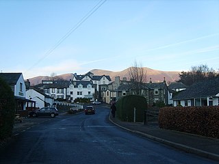
Troutbeck is a hamlet within Cumbria, England, a few miles to the west of Penrith. It was previously in the county of Cumberland. It lies within the Lake District and civil parish of Hutton.

Cliburn is a village and civil parish in the Eden district of Cumbria, England. The civil parish includes the hamlet of Town Head. In 2001 the population was 204, increasing to 274 at the 2011 Census.
Portinscale is a village in Cumbria, England, close to the western shore of Derwentwater in the Lake District National Park 1.5 miles (2.4 km) from Keswick.
Waitby is a small village and civil parish in the Eden district of Cumbria, England. The parish contains two small villages, Waitby and Smardale, plus the small hamlets of Riddlesay, Stripes and Leases, all of which are in the farmed and enclosured northern part at an elevation of around 200–300m. The southern half of the parish is mostly heath and unused for agriculture, it rises to Smardale fell; which it includes, at elevations between 300 and 400m. The civil parish of Ravenstonedale forms the boundary to the south. The western border with Crosby Garrett civil parish is formed by Scandal Beck. To the north and east lie Soulby and Kirkby Stephen civil parishes respectively. The population of the civil parish as measured at the 2011 Census was less than 100. Details are included in the parish of Crosby Garrett.

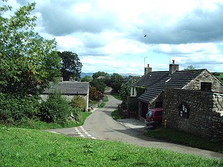
Mosedale is a hamlet in Eden District, Cumbria in the north west of the English Lake District. It is on the River Caldew, north east of Bowscale Fell and south east of Carrock Fell, about one mile north of Mungrisdale. It is in the civil parish of Mungrisdale, which is made up of eight hamlets with a total population of 284 in 2001. From 1866 to 1934 Mosedale was itself a civil parish.
Mosedale Beck may refer to:

Mosedale Beck is a river in Cumbria, England, which rises on the northern slopes of Great Dodd and flows north east, to the south of Clough Head before joining the River Glenderamackin to the east of Threlkeld village. This then flows west, alongside the A66 road south of Blencathra, to form the River Greta which flows into the River Derwent.

Trout Beck is a 7.6 miles (12.3 km) long stream or beck in the English Lake District, Cumbria. It rises on the northwestern slopes of Great Dodd, with tributaries including Groove Beck and Thornsgill Beck, and flows east then north to the hamlet of Troutbeck. It then flows west, parallel to and south of the A66 road, going just south of Hutton Moor End then under the old Hutton Moor Road at Wolt Bridge where it joins the River Glenderamackin.
Cumbrian is an English dialect spoken in Cumberland, Westmorland and surrounding northern England.

