Hutton Moor End

Last updated

Hutton Moor End
Hutton Moor End - geograph.org.uk - 1121797.jpg
Location map United Kingdom Eden.svg
Red pog.svg
Hutton Moor End
Location in Eden, Cumbria
Cumbria UK location map.svg
Red pog.svg
Hutton Moor End
Location within Cumbria
OS grid reference NY365271
Civil parish
District
Shire county
Region
Country England
Sovereign state United Kingdom
Post town PENRITH
Postcode district CA11
Dialling code 01768
Police Cumbria
Fire Cumbria
Ambulance North West
UK Parliament
List of places
UK
England
Cumbria
54°38′06″N2°59′06″W / 54.635°N 2.985°W / 54.635; -2.985 Coordinates: 54°38′06″N2°59′06″W / 54.635°N 2.985°W / 54.635; -2.985

Hutton Moor End is a hamlet on the Hutton Moor Road in the north east of the Lake District in Cumbria, England. It lies within the civil parish of Mungrisdale and is known locally as 'Moor End' as it is at the end of the Hutton Moor on an old route-way between Penrith to Keswick.

Contents

Hamlet and its listed buildings

Hutton Moor End is built around two listed buildings just 25 metres apart, (I) Low House and No.1 Low Moorend (1681) and its close neighbour (II) Moor End Farmhouse and Adjoining Barns (1719). Moor End Farmhouse was for many years a busy coaching inn named 'The Sun Inn', used regularly by stage coaches from Lowther Hall to Keswick. The mounting steps for the horses still remain as does a ring for tethering. An inscription high on an outside wall gives the building's age in Roman numerals. [1] Low House's dated lintel is on its side-gabled stone porch cover's entrance. [2]

Placement on the old route-way

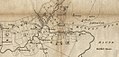
These two listed buildings were built upon an old route-way between Penrith and Keswick on a section known as the Hutton Moor Road. The two listed building's placement on this old-route way can clearly be seen on Thomas Donald's map of Cumberland, 1774 and Clarke's 1787 map as they are the only buildings of Moor End. Apart from a milestone, the Troutbeck Roman sites and a boundary stone they are the only listed buildings on the old road from the east of Threlkeld village to Stainton just outside of Penrith, a distance of 11 miles. The Hutton Moor Road was part of the A594 that was bypassed in the early 1970s by the A66, however the hamlet and a 1.5 mile stretch of the old road remained untouched. The Sea to Sea Cycle Route, which runs from the west coast of Cumbria to the north-east coast, now passes through the hamlet continuing the use of this old route-way.

Hutton Moor End's listed buildings shown on old maps.

Setting

Hutton Moor End is set in an open area with wide views towards the centre of the north Lakes. Looking north and west from Hutton Moor End are uninterrupted views of Sharp Edge on Blencathra, Souther Fell, the vale of Keswick and Castlerigg Stone Circle. There is a view in-between the Listed Buildings towards the south east of Great Mell Fell showing an ancient tumulus at its summit. Another old route-way, the Old Coach Road can be seen looking south running below Clough Head, Wolf Crags and along the base of Great Dodd. Although Moor End's setting is in a wide open area unusually no towns or villages can be seen from it only small settlements and farms are visible. To the north of the hamlet runs the river Glenderamackin and very near to the east of Hutton Moor End are the Troutbeck Roman temporary or marching camps proving the immediate area's importance as a transport corridor. This group of Roman sites played an important military role in the policing of the Lake District and its indigenous population and controlling access into the northern Lakes. Since the recent discovery of a Roman camp, said to be of national significance close to Castlerigg Stone Circle, historians now believe that it could prove right their previous predictions that the Roman road continued from Troutbeck to Keswick passing straight through the setting of Hutton Moor End. [3]

Sharp Edge, Blencathra from Hutton Moor End. Sharp Edge, Blencathra from Hutton Moor End.jpg
Sharp Edge, Blencathra from Hutton Moor End.
Looking west on the Hutton Moor Road at Hutton Moor End. Looking west on the Hutton Moor Road.jpg
Looking west on the Hutton Moor Road at Hutton Moor End.

Present day

To this day Hutton Moor End's roadside has never expanded and is still just the two listed buildings with their attachments. The hamlet has no public amenities, the nearest church being over 2 miles away at Mungrisdale and the nearest pub being the White Horse Inn at Scales more than a mile away. A caravan site's holiday usage is set off the hamlet's roadside towards the small Troutbeck river running to the east. The attachment to Low House is its old converted barn and attached to the old farmhouse is a cottage once used as a forge.

The Lake District National Park, which Hutton Moor End is a part of, became a UNESCO World Heritage Site under the Cultural landscape category in 2017. [4]

Low House & Number 1 Low Moorend Low House & Number 1 Low Moorend.jpg
Low House & Number 1 Low Moorend
Moor End Farmhouse Moor End Farmhouse and barns, from 'The Hutton Moor Road' (1).jpg
Moor End Farmhouse

See also

Related Research Articles

A66 road Trans-Pennine A road in Northern England

The A66 is a major road in Northern England, which in part follows the course of the Roman road from Scotch Corner to Penrith. It runs from east of Middlesbrough in North Yorkshire to Workington in Cumbria.

Keswick, Cumbria Town and parish in the English Lake District National Park

Keswick is an English market town and a civil parish, historically in Cumberland, and since 1974 in the Borough of Allerdale in Cumbria. Lying within the Lake District National Park, Keswick is just north of Derwentwater and is 4 miles (6.4 km) from Bassenthwaite Lake. It had a population of 5,243 at the 2011 census.

Castlerigg stone circle Stone circle near Keswick in Cumbria, North West England

The stone circle at Castlerigg is situated near Keswick in Cumbria, North West England. One of around 1,300 stone circles in the British Isles and Brittany, it was constructed as a part of a megalithic tradition that lasted from 3,300 to 900 BC, during the Late Neolithic and Early Bronze Ages.

The Cockermouth, Keswick and Penrith Railway (CK&PR) was an English railway company incorporated by Act of Parliament on 1 August 1861, to build a line connecting the town of Cockermouth with the London and North Western Railway (LNWR) West Coast Main Line at Penrith. Arrangements for the use of the stations at either end were included. Passenger and goods traffic was worked by the LNWR and mineral traffic by the North Eastern Railway, both of whom had shares in the company. The line was 31+12 miles (50.7 km) in length, and had eight intermediate stations.

Great Mell Fell

Great Mell Fell is an isolated hill or fell in the English Lake District, north of Ullswater and adjacent to the Eastern Fells. It rises from a level plain to a height of 537 m. Its top is an excellent viewpoint for many of the surrounding higher fells. The fell is now owned and managed by the National Trust and offers a place of quiet refuge.

Stanton Drew Human settlement in England

Stanton Drew is a small village and civil parish within the affluent Chew Valley in Somerset, England, situated north of the Mendip Hills, 8 miles (12.9 km) south of Bristol in the Bath and North East Somerset Unitary Authority.

River Greta, Cumbria

The River Greta is a river in Cumbria, England. It is a tributary of the River Derwent and flows through the town of Keswick. "Greta" derives from the Old Norse "Griótá", meaning "stony stream". The name is in records dating from the early 13th century, and also appears in Latinised form, as "Gretagila", at the time of Magna Carta.

Troutbeck, Eden Human settlement in England

Troutbeck is a hamlet within Cumbria, England, a few miles to the west of Penrith. It was previously in the county of Cumberland. It lies within the Lake District and civil parish of Hutton.

Northern Fells

The Northern Fells are a mountain range in the English Lake District. Including Skiddaw, they occupy a wide area to the north of Keswick. Smooth sweeping slopes predominate with a minimum of tarns or crags. Blencathra in the south east of the group is the principal exception to this trend.

Mellor Hall

Mellor Hall is a country house in Mellor, Greater Manchester, England, 0.4 miles (0.64 km) north of the Devonshire Arms off Longhurst Lane.

Stagecoach Cumbria & North Lancashire Bus operator

Stagecoach Cumbria & North Lancashire is a major operator of bus services in North West England. It is a subsidiary of the Stagecoach Group, and has its origins in the purchase of Cumberland in 1987 and Ribble in 1988 from the National Bus Company. The head office of Stagecoach Cumbria & North Lancashire is in Carlisle. It was previously known as Stagecoach North West until 1 September 2011, when Stagecoach Merseyside joined Preston and Chorley depots to form Stagecoach Merseyside & South Lancashire.

Redmain, Cumbria Human settlement in England

Redmain is a small hamlet in the Isel Valley and parish of Blindcrake within the Lake District National Park in Cumbria, England. The hamlet lies on the south-facing slopes above the River Derwent, in an elevated position of 475 feet (145 m), giving panoramas across the Isel Valley and Lake District Fells. Nearby are the hamlets of Isel and Sunderland and the village of Blindcrake.

Brocavum

Brocavum is the Latin name of a Roman fort at Brougham near Penrith, Cumbria. The fort survives as earthworks, but no excavation of these has been carried out so far.

The Keswick to Barrow Walk, also known as the K2B, is a 40 mile charity walking and running event which takes place annually in May in Cumbria, England, between Keswick and Barrow-in-Furness. The walk passes through much of the Lake District. It allows participants to run or walk as they choose. Most choose to walk, while the running contingent compete for the fastest runner trophy.

Over Stratton Village in Somerset, England

Over Stratton is a small village in the district of South Somerset, Somerset, England. It is part of the parish of South Petherton along with the nearby hamlets of Lower Stratton, Wigborough, Yeabridge and Watergore. As of census day 2011, the population was 317.

Mungrisdale is a civil parish in the Eden District, Cumbria, England. It contains 47 listed buildings that are recorded in the National Heritage List for England. Of these, three are listed at Grade II*, the middle of the three grades, and the others are at Grade II, the lowest grade. The parish is in the Lake District National Park, and is sparsely populated, consisting mainly of countryside, moorland and fells. There are small settlements at Mungrisdale, Mosedale, Haltcliff Bridge, Southerfell, Berrier, Hutton Moor End, Hutton Roof, Low Mill, and Swineside. Most of the listed buildings are houses, farmhouses and farm buildings, the other listed buildings including a Friends' meeting house, bridges, a church, a former saw mill, a former school, eight boundary stones, and a telephone kiosk.

Trout Beck (Glenderamackin)

Trout Beck is a 7.6 miles (12.3 km) long stream or beck in the English Lake District, Cumbria. It rises on the northwestern slopes of Great Dodd, with tributaries including Groove Beck and Thornsgill Beck, and flows east then north to the hamlet of Troutbeck. It then flows west, parallel to and south of the A66 road, going just south of Hutton Moor End then under the old Hutton Moor Road at Wolt Bridge where it joins the River Glenderamackin.

East Keswick is a civil parish in the metropolitan borough of the City of Leeds, West Yorkshire, England. The parish contains nine listed buildings that are recorded in the National Heritage List for England. All the listed buildings are designated at Grade II, the lowest of the three grades, which is applied to "buildings of national importance and special interest". The parish contains the village of East Keswick and the surrounding countryside. The listed buildings consist of houses, farmhouses and farm buildings, a public house, and two milestones.

References

  1. England, Historic. "MOOR END FARMHOUSE AND ADJOINING BARNS, Mungrisdale - 1145620". historicengland.org.uk. Retrieved 14 March 2018.
  2. England, Historic. "LOW HOUSE AND NUMBER ONE LOW MOOREND, Mungrisdale - 1145614". historicengland.org.uk. Retrieved 14 March 2018.
  3. "Castlerigg Stone Circle". www.keswick.org. Retrieved 14 March 2018.
  4. "What is a World Heritage Site?". Lake District National Park. Retrieved 17 March 2018.