
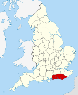
East Sussex is a non metropolitan county in South East England on the English Channel coast. It is bordered by the non metropolitan counties of Kent to the north and east, West Sussex to the west, and Surrey for a short distance to the north-west.

West Sussex is a county in South East England on the English Channel coast. The ceremonial county comprises the shire districts of Adur, Arun, Chichester, Horsham, and Mid Sussex, and the boroughs of Crawley and Worthing. Covering an area of 1,991 square kilometres, West Sussex borders Hampshire to the west, Surrey to the north, and East Sussex to the east. The county town and only city in West Sussex is Chichester, located in the south-west of the county. This was legally formalised with the establishment of West Sussex Council in 1888 but within the ceremonial Sussex. After the reorganisation of local government in 1974, the ceremonial function of the historic county of Sussex was divided into two separate counties, West Sussex and East Sussex. The existing East and West Sussex councils took control respectively, with Mid Sussex and parts of Crawley being transferred to the West Sussex administration from East Sussex. In the 2011 census, West Sussex recorded a population of 806,900.

The River Arun is a river in the English county of West Sussex. At 37 miles (60 km) long, it is the longest river entirely in Sussex and one of the longest starting in Sussex after the River Medway, River Wey and River Mole. From the series of small streams that form its source in the area of St Leonard's Forest in the Weald, the Arun flows westwards through Horsham to Nowhurst where it is joined by the North River. Turning to the south, it is joined by its main tributary, the western River Rother, and continues through a gap in the South Downs to Arundel to join the English Channel at Littlehampton. It is one of the faster flowing rivers in England, and is tidal as far inland as Pallingham Quay, 25.5 miles (41.0 km) upstream from the sea at Littlehampton. The Arun gives its name to the Arun local government district of West Sussex.

The South Downs are a range of chalk hills that extends for about 260 square miles (670 km2) across the south-eastern coastal counties of England from the Itchen valley of Hampshire in the west to Beachy Head, in the Eastbourne Downland Estate, East Sussex, in the east. The Downs are bounded on the northern side by a steep escarpment, from whose crest there are extensive views northwards across the Weald. The South Downs National Park forms a much larger area than the chalk range of the South Downs and includes large parts of the Weald.

Wealden is a local government district in East Sussex, England. Its council is based in Hailsham. The district's name comes from the Weald, the remnant forest which was once unbroken and occupies much of the centre and north of the area.

The River Rother flows from Empshott in Hampshire, England, to Stopham in West Sussex, where it joins the River Arun. At 52 kilometres (32 mi) long, most of the river lies within West Sussex except for the first 10 kilometres (6.2 mi) which lie in Hampshire. The upper river, from its source to Midhurst, has been used to power watermills, with the earliest recorded use being in 1086, when the Domesday survey was conducted. Although none are still operational, many of the buildings which housed the mills still exist, and in some cases, still retain their milling machinery. This upper section is also noted for a number of early bridges, which have survived since their construction in the fifteenth, sixteenth and seventeenth centuries.

Chichester is a local government district in West Sussex, England. Its council is based in the city of Chichester and the district also covers a large rural area to the north.

The A28 is a trunk road in the counties of Kent and East Sussex in south east England, connecting Margate, Canterbury, Ashford and Hastings.

The South Downs National Park is England's newest national park, designated on 31 March 2010. The park, covering an area of 1,627 square kilometres (628 sq mi) in southern England, stretches for 140 kilometres (87 mi) from Winchester in the west to Eastbourne in the east through the counties of Hampshire, West Sussex and East Sussex. The national park covers the chalk hills of the South Downs and a substantial part of a separate physiographic region, the western Weald, with its heavily wooded sandstone and clay hills and vales. The South Downs Way spans the entire length of the park and is the only National Trail that lies wholly within a national park.

The High Weald Area of Outstanding Natural Beauty is in south-east England. Covering an area of 1,450 square kilometres (560 sq mi), it takes up parts of Kent, Surrey, East Sussex, and West Sussex. It is the fourth largest Area of Outstanding Natural Beauty (AONB) in England and Wales. It has an attractive landscape with a mosaic of small farms and woodlands, historic parks, sunken lanes and ridge-top villages.

Pulborough is a large village and civil parish in the Horsham district of West Sussex, England, with some 5,000 inhabitants. It is located almost centrally within West Sussex and is 42 miles (68 km) south west of London. It is at the junction of the north–south A29 and the east–west (A283) roads.
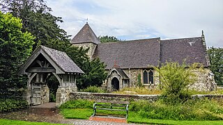
East Chiltington is a village and civil parish in the Lewes District of East Sussex, England. It is centred four miles (5.9 km) south-east of Burgess Hill and five miles (8 km) north-west of Lewes. It is a strip parish of 3.76 square miles (9.7 km2), stretching northward from the crest of the South Downs. The village church is 13th century in origin; the vicar also has charge of two churches in Plumpton. Near the church there is a pub called The Jolly Sportsman. The Sussex Greensand Way, a Roman road, runs from east to west through the centre of the parish.

Tillington is a village, ecclesiastical parish and civil parish in the District of Chichester in West Sussex, England, 1 mile (1.6 km) west of Petworth on the A272. The civil parish (CP) includes the hamlets of Upperton, River, and River Common. The land area of the CP is 1,416 hectares ; approximately 500 people lived in 227 households at the 2001 census.
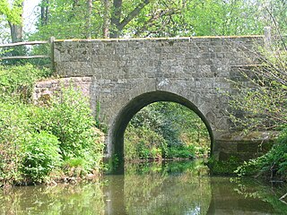
The River Lod is a short river draining about 52 km2 (20 sq mi) of north west Sussex. The source is on Marley Heights near Haslemere, about 140 metres (460 ft) above sea level. From here it flows west past Linchmere, then south to Furnace Pond, where iron cannon were cast during the English Civil War. It then turns south east, flowing south of Fernhurst to Lickfold and Lurgashall where it formerly powered Lurgashall Mill, now moved to the Weald and Downland Open Air Museum. From Mill Farm it heads south between high banks, which it only overflows after the heaviest of rainfalls, passing between the hills of Lodsworth and River to Halfway Bridge on the A272 road then joining the River Rother at Lods Bridge.

Wisborough Green is a village and civil parish in the north of the Chichester district of West Sussex, England, 2 miles (3.2 km) west of Billingshurst on the A272 road.
Sussex is a historic county and cultural region in the south of England corresponding roughly in area to the ancient Kingdom of Sussex. It is bounded on the north by Surrey, north-east by Kent, south by the English Channel, and west by Hampshire, and is divided for local government into West Sussex and East Sussex and the city of Brighton and Hove. The city of Brighton & Hove was created a unitary authority in 1997, and was granted City status in 2000. Until then Chichester had been Sussex's only city. By convention, Chichester is Sussex's capital city and Lewes is Sussex's county town.
The western Weald is an area of undulating countryside in Hampshire and West Sussex containing a mixture of woodland and heathland areas.
The New Lipchis Way is a 60.8 kilometres (37.8 mi) long distance footpath which runs from Liphook in Hampshire to West Wittering in West Sussex. Running north–south across the Western Weald and South Downs to the Sussex coastal plain and Chichester Harbour the path crosses several geological rock strata and their associated soils and habitats. Landmarks on the route include Cowdray ruins, Goodwood Racecourse, the Trundle, Chichester Cathedral and the city walls, and East Head at West Wittering.
The geology of West Sussex in southeast England comprises a succession of sedimentary rocks of Cretaceous age overlain in the south by sediments of Palaeogene age. The sequence of strata from both periods consists of a variety of sandstones, mudstones, siltstones and limestones. These sediments were deposited within the Hampshire and Weald basins. Erosion subsequent to large scale but gentle folding associated with the Alpine Orogeny has resulted in the present outcrop pattern across the county, dominated by the north facing chalk scarp of the South Downs. The bedrock is overlain by a suite of Quaternary deposits of varied origin. Parts of both the bedrock and these superficial deposits have been worked for a variety of minerals for use in construction, industry and agriculture.
Healthcare in Sussex was the responsibility of seven Clinical Commissioning Groups covering: Brighton and Hove; Coastal West Sussex; Horsham and Mid Sussex; Crawley; Eastbourne Hailsham and Seaford; Hastings and Rother; High Weald; and Lewes-Havens from 2013 to 2020. From April 2020 they will be merged into three covering East Sussex, West Sussex, and Brighton and Hove.

