
The River Afan is a river in Wales whose valley formed the territory of the medieval Lords of Afan. The Afan Valley encompasses the upper reaches of the river. The valley is traversed by the A4107 road. Settlements in the area include Cwmafan, Pontrhydyfen and Cymmer. The town of Aberavon, whose name in Welsh Aberafan means 'mouth of the Afan', grew up on the banks of the river and was later subsumed by the town of Port Talbot.

Aberdaron is a community, electoral ward and former fishing village at the western tip of the Llŷn Peninsula in the Welsh county of Gwynedd. It lies 14.8 miles (23.8 km) west of Pwllheli and 33.5 miles (53.9 km) south west of Caernarfon, and has a population of 965. The community includes Bardsey Island, the coastal area around Porthor, and the villages of Anelog, Llanfaelrhys, Penycaerau, Rhoshirwaun, Rhydlios, Uwchmynydd and Y Rhiw. It covers an area of just under 50 square kilometres.

The River Conwy is a river in northern Wales. From its source to its discharge in Conwy Bay it is 55 kilometres (34 mi) long and drains an area of 678 square km. "Conwy" was formerly anglicised as "Conway."
ˈ The Afon Ogwen is a river in north-west Wales draining from some of the greatest peaks in Snowdonia before discharging to the sea on the eastern side of Bangor, Gwynedd.

The River Aeron is a small river in Ceredigion, Wales, that flows into Cardigan Bay at Aberaeron. It is also referred to on some older maps as the River Ayron.

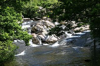
The River Rhondda is a river in South Wales with two major tributaries, Rhondda Fawr and Rhondda Fach.

Afon Seiont is a river in Gwynedd, Wales which runs into the Menai Strait.

The Black Mountain is a mountain range in South, Mid and West Wales, straddling the county boundary between Carmarthenshire and Powys and forming the westernmost range of the Brecon Beacons National Park. Its highest point is Fan Brycheiniog at 802 metres or 2,631 ft. The Black Mountain also forms a part of the Fforest Fawr Geopark.
Afon Ddu is the name of several rivers in Snowdonia in north-west Wales:

The River Dysynni is a river in mid Wales. Its source is the Tal-y-llyn Lake just south of the Cadair Idris massif and its mouth is in the Cardigan Bay area of the Irish Sea to the north of Tywyn. It measures about 16 mi (26 km) in length.

The River Giedd is a principal tributary of the River Tawe, Wales. The river runs within the county of Powys and lies almost wholly within the Brecon Beacons National Park.
The Nant Gwys is a river flowing off the Black Mountain in Powys, Wales. Its tributaries Gwys Fawr and the Gwys Fach flow south from Banwen Gwyn and Bwlch y Ddeuwynt respectively and join forces to form the Nant Gwys proper which then flows for about 5 km / 3 mi to its confluence with the Afon Twrch at Cwm-twrch-Uchaf.

The Afon Sawdde is a river in the county of Carmarthenshire, Wales. For most of its course it flows through the Brecon Beacons National Park and Fforest Fawr Geopark.

The River Terrig is a small river in north-east Wales.

The River Banwy is a river about 19 miles (31 km) long in Powys, Wales. It is a tributary of the River Vyrnwy.

The Mule is a short river in Powys, mid Wales, and a tributary of the River Severn. It rises at Black Gate near the west end of Kerry Hill and is joined by a number of streams, principal amongst which is the Nant Meheli, east of Kerry. Initially flowing northeast it turns to flow east at Kerry and then northwest, entering a narrow section of valley near Llanmerewig before joining the Severn at Abermule.
The Afon Soch is a short river on the Llŷn peninsula, Gwynedd, Wales. It arises to the north of the village of Sarn Meyllteyrn, through which it then flows, turning southeast towards Botwnnog. Beyond Botwnnog it is joined by its main left-bank tributary, the Afon Horon, which rises to the east of Carn Fadryn. Their combined flow approaches the coast at Porth Neigwl but instead the river turns sharply northwards at Llanengan and curves around east to Abersoch where it enters the sea. A short section of the Soch valley is followed by the Wales Coast Path where it takes a route inland of Porth Neigwl. Both the Soch and the Horon are misfit streams within valleys that were formed by glacial meltwater. The river name is reckoned to be of Irish origin, the old Irish word 'socc' meaning a sow. There are a number of other Irish names in Llŷn.
