Related Research Articles
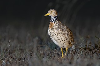
The plains-wanderer is a bird, the only representative of family Pedionomidae and genus Pedionomus. It is endemic to Australia. The majority of the remaining population is found in the Riverina region of New South Wales.

Hay is a town in the western Riverina region of south western New South Wales, Australia. It is the administrative centre of Hay Shire local government area and the centre of a prosperous and productive agricultural district on the wide Hay Plains.

Roebuck Bay is a bay on the coast of the Kimberley region of Western Australia. Its entrance is bounded in the north by the town of Broome, and in the south by Bush Point and Sandy Point. It is named after HMS Roebuck, the ship captained by William Dampier when he explored the coast of north-western Australia in 1699. The Broome Bird Observatory lies on the northern coast of the bay.

The South Western Slopes, also known as the South West Slopes, is a region predominantly in New South Wales, Australia. It covers the lower inland slopes of the Great Dividing Range, extending from north of Dunedoo through central NSW and into northeast Victoria, meeting its southwestern end around Beechworth. More than 90% of the region is in the state of New South Wales and it occupies about 10% of that state.

The Yanga National Park is a newly formed national park, located near the township of Balranald in south- western New South Wales. It covers an area of 66,734 hectares which includes 1,932 hectares of Yanga Nature Reserve, and has a frontage of 170 kilometres (110 mi) on the Murrumbidgee River. It is largely located in the Lower Murrumbidgee Floodplain, which is included on A Directory of Important Wetlands in Australia because of its importance as a breeding site for waterbirds when flooded.

The Southeast Australia temperate savanna ecoregion is a large area of grassland dotted with eucalyptus trees running north–south across central New South Wales, Australia.
Fivebough and Tuckerbil Wetlands are two wetland sites within the Riverina and Murrumbidgee Irrigation Area (MIA), near Leeton in New South Wales, Australia. Both Fivebough and Tuckerbil sites form Crown reserve number 1030008 managed by NSW Department of Industry, for ecological conservation and public recreation. The reserve was recognised as being a Wetland of International Importance through designation under the Ramsar Convention on 21 October 2002 as Ramsar Site 1224

The Griffith Wetlands Important Bird Area is a group of wetlands lying close to the Riverina town of Griffith in southern New South Wales, Australia. It lies within the Murrumbidgee Irrigation Area.

The Gulf Plains Important Bird Area comprises 8868 km2 of the low-lying coastal plains bordering the south-eastern corner of the Gulf of Carpentaria in north-west Queensland, Australia. It was identified by BirdLife International as an Important Bird Area (IBA) because of its importance to global populations of waders and other birds.
The Lowbidgee Floodplain extends from Balranald to near Waradgery Station, about 20 km (12 mi) west of Hay, in south-western New South Wales. The Lowbidgee Floodplain is part of the Traditional lands of the Nari Nari and Muthi Muthi Aboriginal peoples.

The Melaleuca to Birchs Inlet Important Bird Area comprises a 2315 km2 section of coast and sub-coastal land in South West Tasmania. It stretches southward from the southern end of Birchs Inlet, encompasses Melaleuca and Port Davey, and extends to Louisa Bay on the coast facing the Maatsuyker Island group. The area is rugged, with extensive beaches and coastal plains rising to rocky mountains. It contains a mosaic of temperate rainforest, eucalypt forest, moorland and buttongrass plains.
The Murrumbidgee Red Gums Important Bird Area comprises a 2451 km2 discontinuous linear tract of land stretching along the Murrumbidgee River west, and downstream, from Wagga Wagga in the Riverina region of New South Wales, Australia. It includes riverine red gum forest with adjacent woodland and farmland. It adjoins the Riverina Plains Important Bird Area.

The North-west Tasmanian Coast Important Bird Area comprises a 2438 km2 stretch of coastal and subcoastal land covering the northern section of the coast of western Tasmania, south-eastern Australia.
The Patho Plains Important Bird Area comprises a 794 km2 tract of mainly pastoral farmland near the town of Gunbower in north-central Victoria, south-eastern Australia. It contains several relatively small nature conservation reserves as well as the 38 km2 Terrick Terrick National Park.

Peebinga Conservation Park is a 34 km2 protected area lying 40 km north of the town of Pinnaroo in the Murray Mallee region of south-eastern South Australia, about 240 km east of Adelaide and 10 km west of the Victorian border.

The Riverland Mallee Important Bird Area comprises a 12,200 square kilometres tract of mallee habitat and riverine woodland extending from near Waikerie in the Riverland region in eastern South Australia north-eastwards into south-western New South Wales.

Sandy Island is a 20 ha island lying about 5 km (3.1 mi) off the coast of Windy Harbour in south-west Western Australia, and near Point D'Entrecasteaux. It is part of D'Entrecasteaux National Park and is an important breeding site for seabirds.
The Wandown Important Bird Area comprises a 48 km2 disjunct tract of remnant mallee habitat in northern Victoria, south-eastern Australia. It lies close to the junction of the Murray and Murrumbidgee Rivers, some 50 km south-east of the town of Robinvale and 75 km north-west of the city of Swan Hill.

The Buckley River Important Bird Area comprises a 4790 km2 tract of land in the Gulf Country of north-western Queensland, Australia. It lies about 20 km north of the mining city of Mount Isa in the Waggaboonyah Range. It is an important site for Carpentarian grasswrens.
The Boolcoomatta, Bindarrah and Kalkaroo Stations Important Bird Area is a 1402 km2 tract of land in north-eastern South Australia. It comprises three pastoral properties, 53,000 ha Kalkaroo Station, 24,000 ha Bindarrah Station, and 63,000 ha Boolcoomatta. The whole site has been identified by BirdLife International as an Important Bird Area (IBA) because it supports a significant population of endangered plains-wanderers – perhaps the largest population of the species outside the Riverina region of New South Wales.
References
- ↑ "IBA: Riverina Plains". Birdata. Birds Australia. Retrieved 28 September 2011.
- ↑ BirdLife International. (2011). Important Bird Areas factsheet: Riverina Plains. Downloaded from http://www.birdlife.org on 28/09/2011.
Coordinates: 34°50′46″S145°26′52″E / 34.84611°S 145.44778°E